This week starts unsettled for large parts of the North Sea, with low pressure moving from the UK towards southwest Norway today. After that, conditions will gradually become more favorable. Especially towards the end of this week, there seem to be many moments to perform your marine operations over the central and southern North Sea.
During Friday and Saturday, the influence of high pressure is still noticeable over the North Sea. Low pressure is forced to take a more northerly route, mainly affecting the northern North Sea and the northern parts of the central North Sea. The southern North Sea shows plenty of working opportunities during these days. However, at this time the exact positioning of these low pressure areas is still uncertain. After the weekend, it is likely that the entire North Sea will experience adverse conditions again.
A ridge will temporarily ease conditions over the North Sea between late tomorrow morning and the start of the evening. Winds will drop to moderate or fresh, 4-5 Beaufort. Winds are expected to pick up again from the west in the late afternoon, becoming strong overall until Thursday noon. Very locally, winds may reach just into near gale force. Waves generally build up again to 2.5-3.0 meters over the entire North Sea.
From Thursday afternoon onwards, winds are expected to come down again as high pressure over France increases its influence over the North Sea. Winds are expected to gradually come down to moderate by Friday morning, with the significant wave height dropping to 1.0-1.5 meters in many places. However, the northern North Sea is still expected to experience fresh winds with waves between 2.0-2.5 meters.
During the weekend, low pressure mainly affects the northern North Sea and some parts of the central North Sea. Winds are expected to be fresh to strong over the southern half of the North Sea, while it may reach near gale force again in the northern North Sea. Details are however uncertain at this moment, and will become more and more clear during the coming days.
Synoptic overview
At the moment of writing, low pressure is present over the central and northern North Sea, gradually moving north-northeast today. It is expected to merge with another low pressure area over the Norwegian Sea tonight. The associated trough leaves the North Sea to the east early tomorrow. In its wake, a mobile high pressure ridge crosses the North Sea from west to east, temporarily easing the wind and wave conditions. Later tomorrow, next frontal trough is expected to cross the North Sea. Associated low pressure is expected to move east across the Shetlands early Thursday, before moving into Scandinavia later that day. By then, high pressure is expected to have developed over France with a weak ridge extending towards the North Sea.During Friday and Saturday, the influence of high pressure is still noticeable over the North Sea. Low pressure is forced to take a more northerly route, mainly affecting the northern North Sea and the northern parts of the central North Sea. The southern North Sea shows plenty of working opportunities during these days. However, at this time the exact positioning of these low pressure areas is still uncertain. After the weekend, it is likely that the entire North Sea will experience adverse conditions again.
Wind and waves
Today is the most unsettled day of the week, with low pressure affecting the entire North Sea. On the southern and southwestern flank of this low pressure area, winds will reach near gale force (7 Beaufort) over the southern North Sea. Highest wind are expected on the southwestern flank of this low pressure area, with a narrow band of gale force winds affecting the central and northern North Sea. This wind field will leave the North Sea to the east early tomorrow. The significant wave height is expected to increase to 3.0-3.5 meters over the southern North Sea today, while waves may exceed 4.0 meters over the central North Sea early tomorrow.A ridge will temporarily ease conditions over the North Sea between late tomorrow morning and the start of the evening. Winds will drop to moderate or fresh, 4-5 Beaufort. Winds are expected to pick up again from the west in the late afternoon, becoming strong overall until Thursday noon. Very locally, winds may reach just into near gale force. Waves generally build up again to 2.5-3.0 meters over the entire North Sea.
From Thursday afternoon onwards, winds are expected to come down again as high pressure over France increases its influence over the North Sea. Winds are expected to gradually come down to moderate by Friday morning, with the significant wave height dropping to 1.0-1.5 meters in many places. However, the northern North Sea is still expected to experience fresh winds with waves between 2.0-2.5 meters.
During the weekend, low pressure mainly affects the northern North Sea and some parts of the central North Sea. Winds are expected to be fresh to strong over the southern half of the North Sea, while it may reach near gale force again in the northern North Sea. Details are however uncertain at this moment, and will become more and more clear during the coming days.
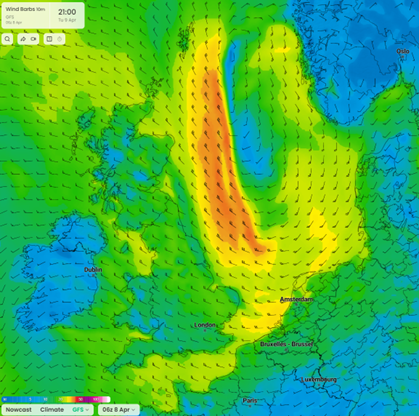 Figure 1: Wind speed in knots according to the American GFS model on Tuesday April 9th at 21 UTC.
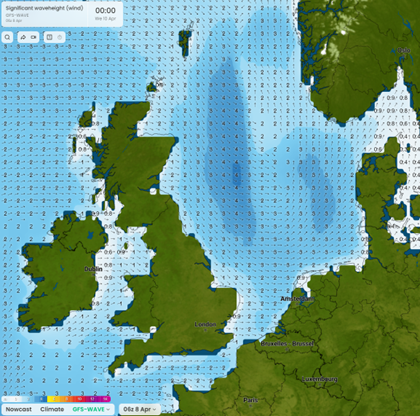 Figure 2: Significant wave height in meters according to the American GFS wave model on Wednesday April 10th at 00 UTC.
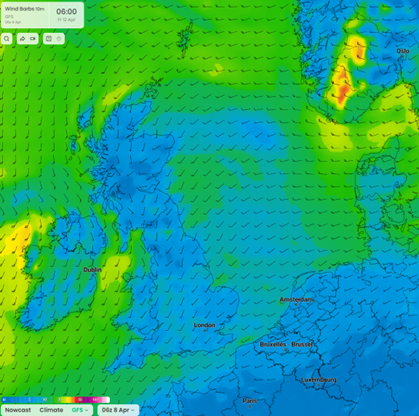 Figure 3: Wind speed in knots according to the American GFS model on Friday April 12th at 06 UTC.
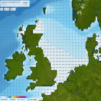 Figure 4: Significant wave height in meters according to the American GFS wave model on Friday April 12th at 12 UTC.
Conclusion
After an unsettled start, conditions are expected to gradually improve during the next couple of days. This is especially true for the central and southern parts of the North Sea. The northern North Sea remains under the influence of low pressure areas, which take a more northerly route by the end of the week. Unfortunately, models still struggle with the exact positioning of these low pressure areas, keeping the confidence low for that period.Always up-to-date
Like this weather briefing? Our monthly newsletter gives you even more insights. Think about the marine weather phenomena, updates about our ever-evolving forecasting products, and the latest and most relevant marine weather briefing. Subscribe to receive our Infoplaza marine newsletter once a month.