
A low-pressure core above the Netherlands is gradually moving southeastward, filling in. Simultaneously, a high-pressure system over the Bay of Biscay is connecting with a high-pressure system over Scandinavia. The associated ridge extends over the North Sea, leading to a temporary stabilization of the weather. On Wednesday, a warm front pushes the ridge southward. On Thursday, a cold front moves southeastward over the North Sea, while high pressure builds over Iceland and Greenland. As a result, polar air moves southward over the North Sea from Friday onwards.
Synoptic overview
High pressure is located northwest of Portugal, while another high-pressure system is situated over Scandinavia. Both high-pressure systems connect over the North Sea. This ridge descends further south during Wednesday. At the same time, a deep low-pressure system moves from Greenland to the Norwegian Sea. Its associated warm front crosses the North Sea on Wednesday, followed by the cold front on Thursday. Meanwhile, the previously mentioned high northwest of Portugal builds a ridge towards Iceland and Greenland. Low pressure is present over Scandinavia. Between these two pressure systems, a northwesterly airflow carries polar air over the North Sea to the south. The ridge gradually shifts towards the UK over the weekend, leading to a decrease in wind and variability in most areas.Wind and waves
Figure 1 shows the high-pressure ridge building up over the North Sea on Tuesday. Across the entire North Sea, the weather will be calm with little wind, and waves mostly around or below 2 meters (see Figure 2). The ridge will gradually move southeastward due to the influence of a deep low-pressure system between Iceland and Greenland later on Wednesday.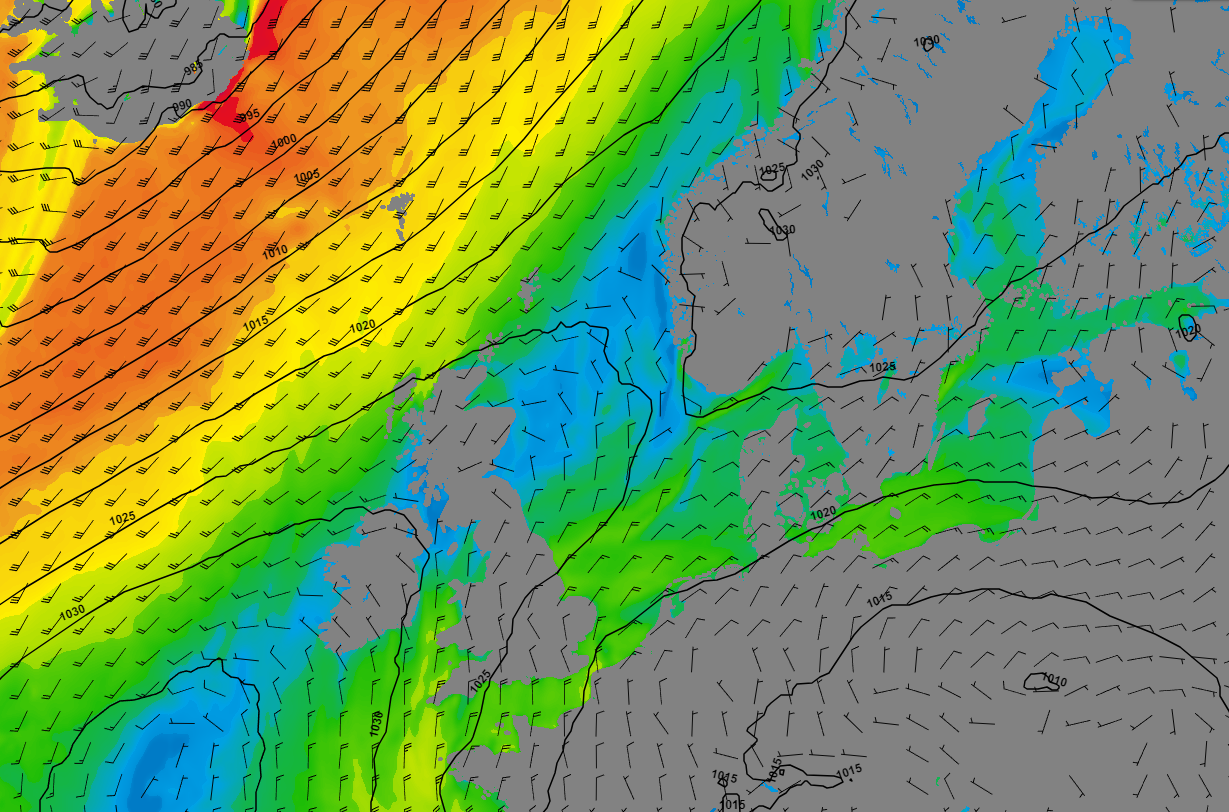 Figure 1: Wind speed and wind direction according to GFS on Tuesday 21 November at 12UTC.
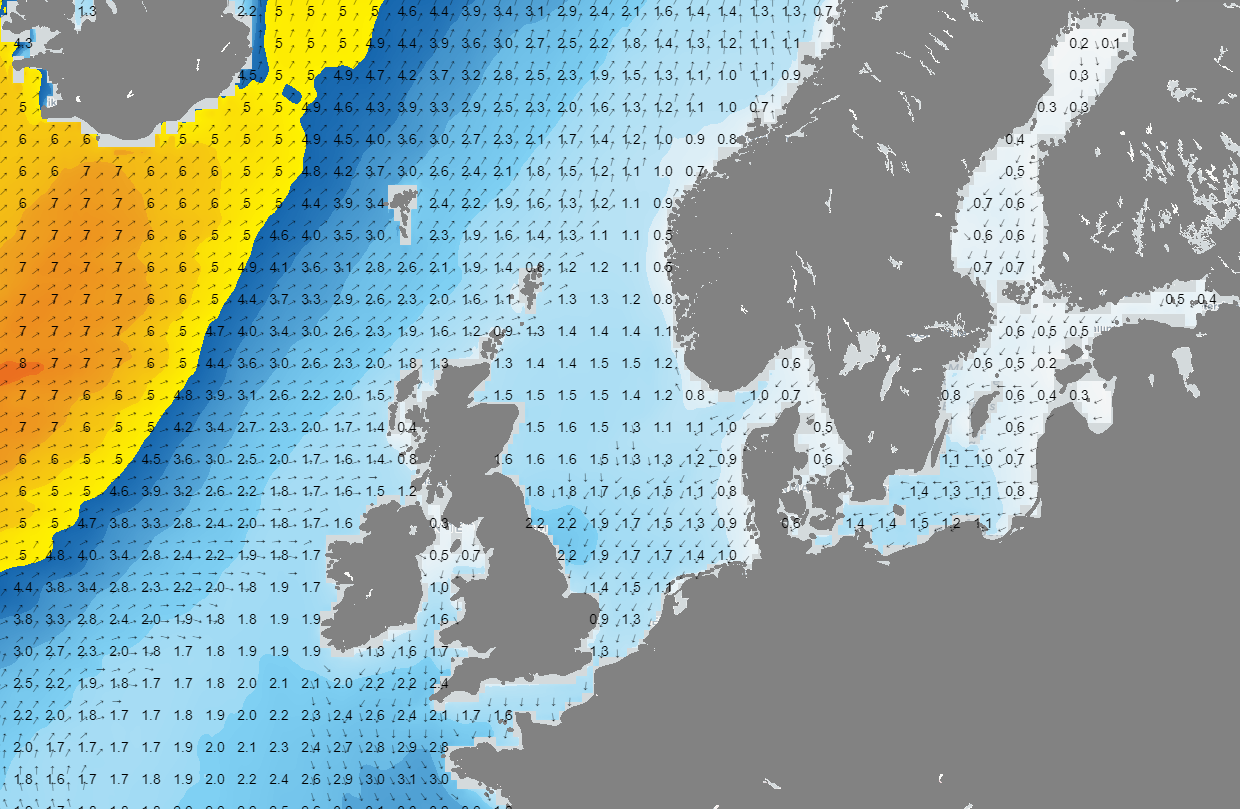 Figure 2: Significant wave height and wave direction according to GFS on Tuesday 21 November at 12UTC.
As explained in the synoptic overview, a warm front crosses the North Sea on Wednesday, followed by a cold front on Thursday. On both fronts, there will be substantial rainfall, and the wind will increase to values between 25 and 35 knots. After the passage of the cold front, the wind shifts to the north to northwest, bringing significantly colder air southward over the North Sea. Especially on Friday, the pressure gradient over the North Sea is large, and winds reach 30 to locally 40 knots in many areas, corresponding to Beaufort scale 7 to 8. Due to the strong wind, cold upper air, and a long fetch, waves build up to around 5 meters offshore in the North Sea. Near the coast, waves are also high but slightly lower at 3-4 meters compared to offshore. Throughout the weekend, the pressure gradient decreases, causing the wind and eventually the waves to slowly subside.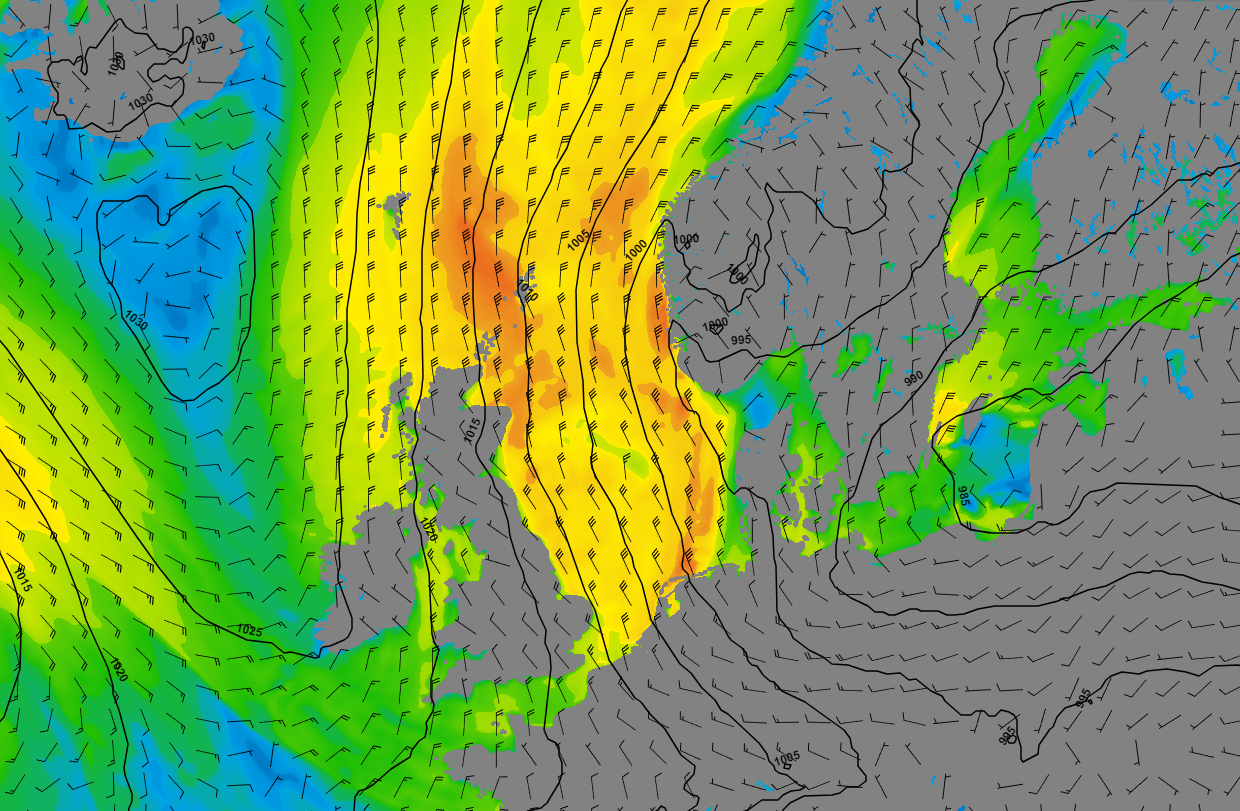 Figure 3: Wind speed and wind direction on Saturday the 25th of November at 00UTC.
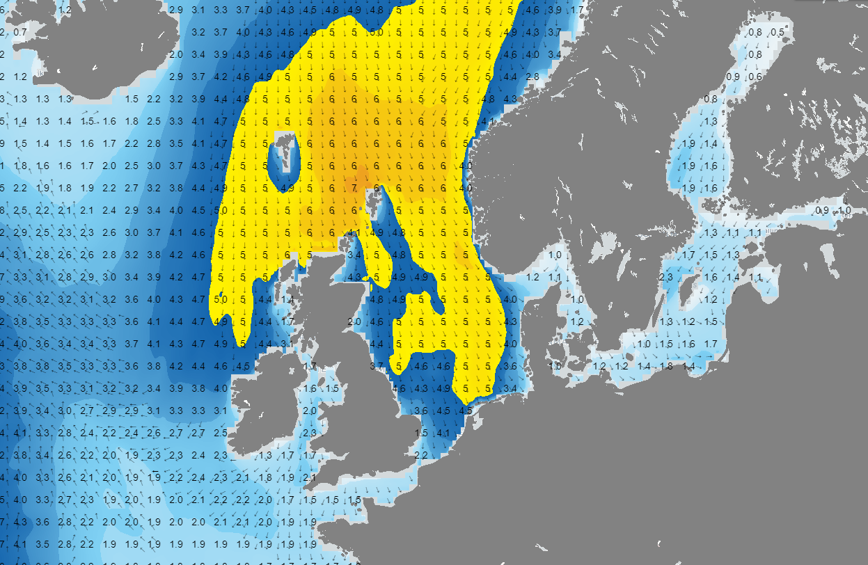 Figure 4: Significant wave height and wave direction on Saturday the 25th of November at 00UTC.
Conclusion
Especially on Tuesday and Wednesday, the weather is relatively calm over large parts of the North Sea, with little wind and waves mostly below 2 meters. On Thursday and Friday, fronts move across, and the wind gradually increases in strength. Particularly on Friday and Saturday, a strong northerly wind is expected (force 7-8), generating waves of up to 5 meters or more due to the long fetch. On Sunday, the wind slightly diminishes in strength, but it continues to blow from the north to northwest, keeping the waves persistently high.Always up-to-date
Like this weather briefing? Our monthly newsletter gives you even more insights. Think about marine weather phenomena, updates about our ever-evolving forecasting products, and the latest and most relevant marine weather briefing. Subscribe to receive our Infoplaza marine newsletter once a month.


