After a period of relatively low temperatures, wintry showers, and an east wind, the west wind takes control again starting this week. Today (Tuesday) this is not yet the case. A low-pressure area is situated above the Netherlands and is moving eastward. To the north of this low, the cold air still prevails, under a weak ridge of high pressure. Later in the week, a complex low-pressure system will develop above and to the west of the UK. This low brings mild air into the North Sea with a southern flow. At the same time, unsettled weather conditions will return.
There's a video briefing at the end of this article
Synoptic overview
A low-pressure area is situated above the Netherlands. This low is moving eastward today (Tuesday). Simultaneously, a high-pressure area is positioned over Russia and Scandinavia. An associated weak ridge is located over the northern and central North Sea. This high and its associated ridge will move further east on Wednesday. At the same time, a deep low forms southwest of Ireland. This low deepens considerably over the UK on Thursday, bringing noticeably milder air to the North Sea. On Friday, this low slowly fills, but associated frontal systems linger over the North Sea. On Saturday, a new low develops over the ocean, steering towards the UK once again. This low will bring unsettled conditions over the North Sea during the weekend.
Wind and waves
Figure 1 shows the low pressure area over the Netherlands moving east in the night to Wednesday. Meanwhile, the wind remains very calm over the northern half of the North Sea (2-3 Beaufort). Closer to the eastward moving low, wind speeds will likely be around 5-6 Beaufort.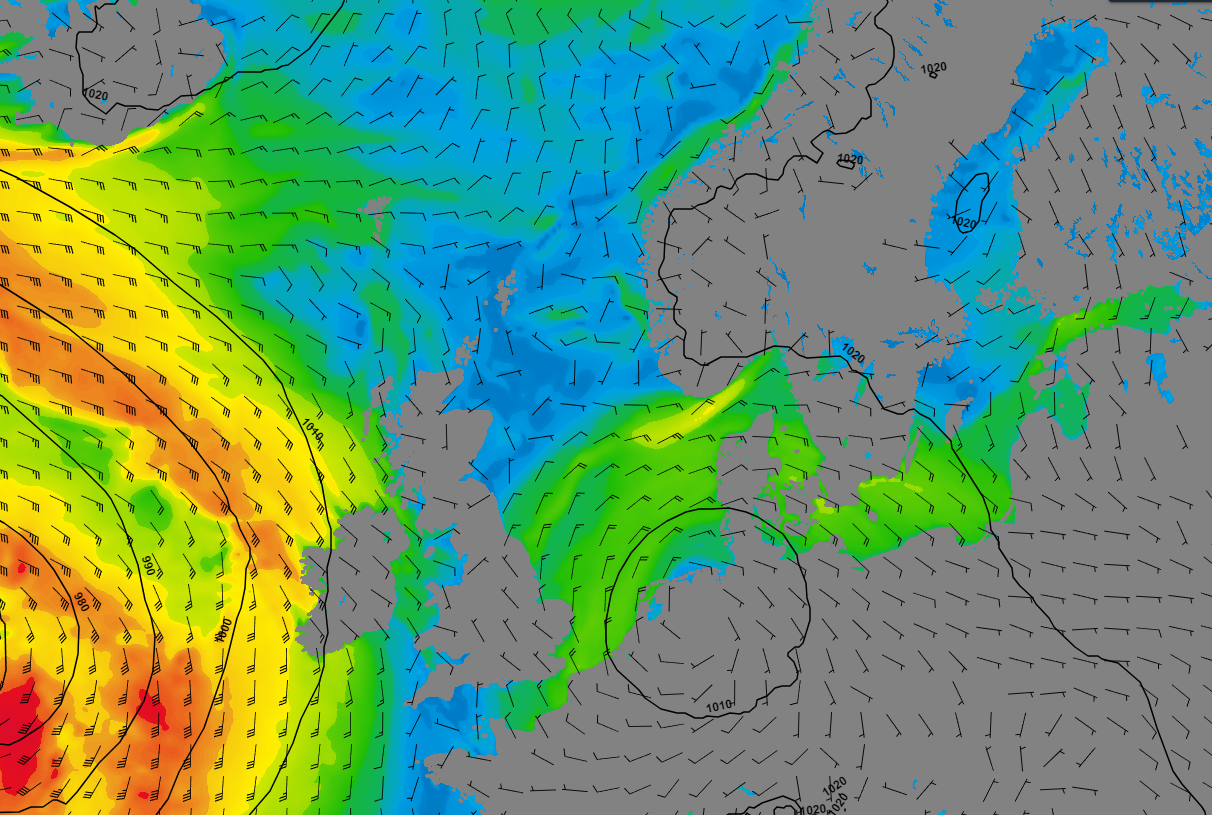 Figure 1: Wind speed and wind direction according to GFS on Wednesday at 00UTC.
Due to very little wind over the northern half of the North Sea, waves will remain calm as well. Hs will vary in between 1-1.5m for most locations. As the wind is stronger closer to the eastward moving low, the waves will increase as well. Hs will likely be around 2 meters over the southern half of the North Sea, according to Figure 2.
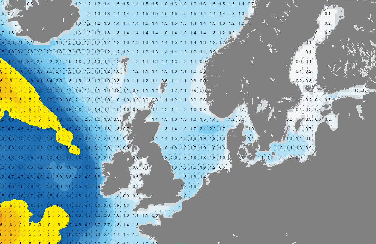 Figure 2: Significant wave height (Hs) and wave direction according to GFS on Wednesday at 00UTC.
However, conditions will deteriorate quickly on Thursday, as a low pressure area approaches the UK and associated frontal troughs will move into the North Sea. It is still uncertain what the exact track and development of that low will be, but Figure 3 gives an indication off what can be expected. Figure 3 shows gale force winds over the northern parts of the North Sea. The core of the low pressure area is located over Scotland in this scenario. Important to note is that this scenario is according to the GFS model. ECMWF shows a much less severe scenario. Nonetheless, the weather will be unsettled with possibly a lot of wind and high waves in both scenarios.
Figure 4 shows both Hs and wave direction according to the GFS scenario. Due to the strong winds over the northern half of the North Sea, the model calculates enormous waves there (Hs of 7-8m). Hs will decrease when moving into a southerly direction over the North Sea. This is mainly due to less strong winds and a shorter fetch. Important to note again is that the ECMWF scenario calculates less extreme waves (in the order of 5m Hs) over the middle and northern parts of the North Sea.
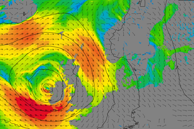 Figure 3: Wind speed and wind direction according to GFS on Friday at 00UTC.
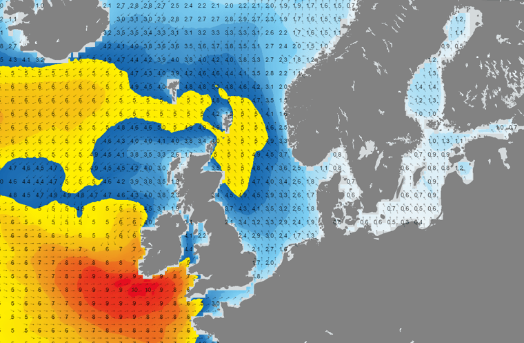 Figure 4: Significant wave height (Hs) and wave direction according to GFS on Friday at 00UTC.
Conclusion
After a period of relatively cold weather, the tables turn this week. From Thursday onward, it turns mild again and becomes quite unsettled over the North Sea. Especially on Friday and Saturday, there will be times with stormy winds. Due to the southern wind, waves will be particularly high, especially in the northern part of the North Sea (longest fetch).
Always up-to-date
Like this weather briefing? Our monthly newsletter gives you even more insights. Think about marine weather phenomena, updates about our ever-evolving forecasting products, and the latest and most relevant marine weather briefing. Subscribe to receive our Infoplaza marine newsletter once a month.


