
A sharp front is moving southeastward over the North Sea today. Behind the front, the wind shifts to the west to northwest, bringing cooler air over the North Sea. At the same time, the wind is blowing strongly, and there are high waves over a large part of the North Sea. On Wednesday, the weather temporarily calms down. Later, a new frontal system moves in. Behind the cold front, the wind further turns to the northwest and intensifies again. A strong northwesterly wind causes high waves, especially on Friday. Throughout the weekend, the northwesterly flow gradually weakens.
Synoptic overview
A sharp cold front will leave the Netherlands later today. Behind this front, the wind over the North Sea has shifted to the west to northwest, causing cooler air to flow southward. A weak high-pressure ridge will move from west to east over the North Sea on Wednesday, temporarily calming the weather. On Thursday, a frontal system will move from northwest to southeast across the North Sea. Behind the cold front, the wind will again shift to the northwest and increase significantly in strength. The associated low-pressure area will move from Iceland to the south of Scandinavia. Over the weekend, the strong northwesterly flow will slowly diminish in strength. There is a possibility of a secondary low-pressure area forming over the North Sea, but that is still very uncertain at this stage.Wind and waves
Figure 1 shows both wind speed and wind direction on Wednesday at 00UTC. The previously mentioned front has passed the North Sea and the wind shifted to the west and northwest as a result. Sustained wind speeds up to force 6-7 is present over a large part of the North Sea. During strong showers the wind might increase a little bit more.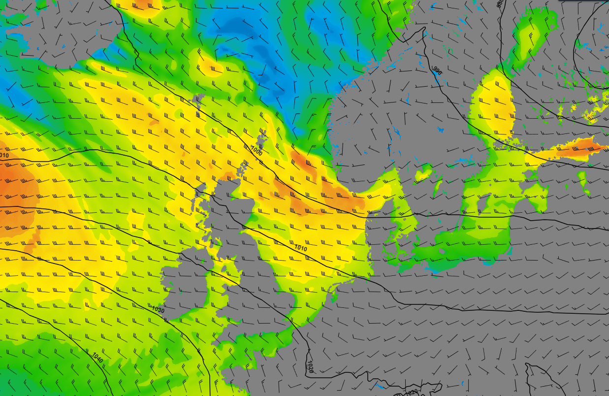 Figure 1: Wind speed and wind direction according to GFS on Wednesday at 00UTC.
Figure 2 shows significant wave height (Hs) and wave direction on Wednesday at 00UTC. Due to the strong west to northwesterly flow, waves can build up to 3-4 meters and locally up to 5 m during strong showers over the middle and northern half of the North Sea. Due to the westerly flow, the UK provides some shelter for the most western half of the North Sea, resulting in slightly less high waves.
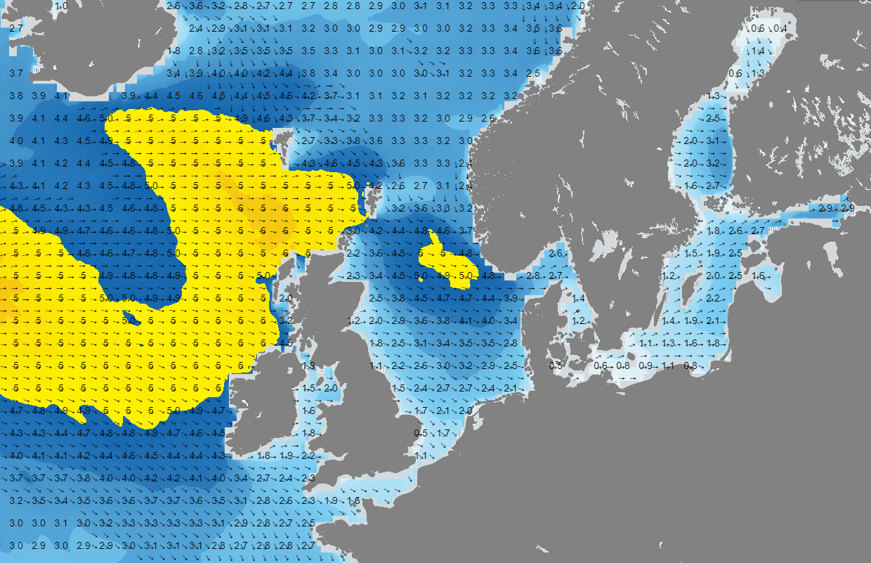 Figure 2: Significant wave height and wave direction according to GFS on Wednesday at 00UTC.
After a brief period of calmer weather later on Wednesday, fronts will pass over again during the night towards Thursday and throughout Thursday. By Thursday, the wind will shift to the northwest (see Figure 3). The pressure gradient over the North Sea is greater than the situation mentioned earlier on Wednesday. As a result, particularly on Thursday evening and early Friday, there will be strong winds. Over large parts of the North Sea, a stormy wind is blowing, and locally it may reach storm force.
Due to the northwesterly wind and the long fetch, the waves will be high. According to the American weather model GFS (Figure 4), waves of 5 to locally 8 meters are expected over large parts of the North Sea. The European weather model is slightly less extreme, predicting waves of 4 to 6 meters significant wave height (Hs). In any case, the North Sea is expected to be very turbulent.
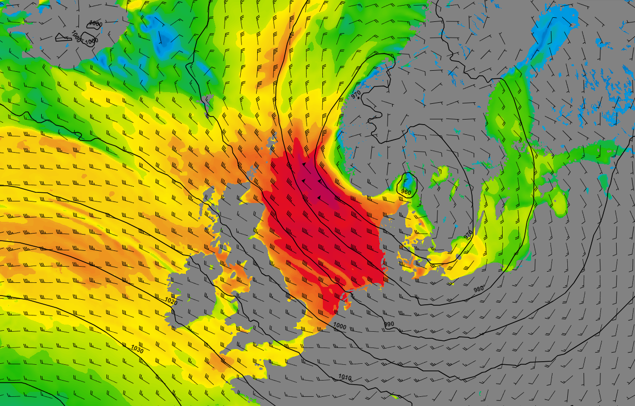 Figure 3: Wind speed and wind direction according to GFS on Thursday at 18UTC.
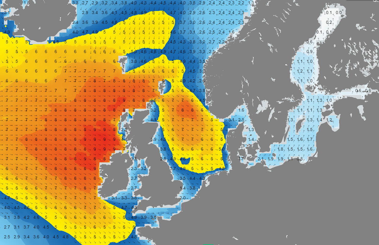 Figure 4: Significant wave height and wave direction according to GFS on Thursday at 18UTC.
Conclusion
The upcoming week will be characterized by highly variable weather. On Tuesday, colder air will move over the North Sea, and the wind will increase significantly (force 6-7). At the same time, significant wave height (Hs) is expected to rise to 3, locally up to 5 meters. The most severe weather is forecasted for later on Thursday and Friday. During these periods, the wind over large parts of the North Sea is expected to be stormy (force 8-9). The strong wind, combined with a long fetch, will also result in high waves. The American weather model predicts extremely high waves, ranging from 5 to locally 8 meters Hs. The European weather model is slightly more conservative, forecasting waves of 4 to 6 meters Hs. In any case, later in the week, the weather on the North Sea will be both windy and wavy.Always up-to-date
Like this weather briefing? Our monthly newsletter gives you even more insights. Think about the marine weather phenomena, updates about our ever-evolving forecasting products and the latest and most relevant marine weather briefing. Subscribe to receive our Infoplaza marine newsletter once a month.


