After a few days of relatively calm weather, the unsettled weather returns over a large part of the North Sea. However, the differences between the northern and southern North Sea will be significant this week. While the weather remains relatively calm around the Dutch coast, it becomes quite stormy further north in the North Sea. In this North Sea briefing, we will specifically focus on these conditions.
Synoptic overview
High pressure will be situated over the western part of France and the Bay of Biscay in the coming days. A small low-pressure system over the southern North Sea is moving northeastward today (Tuesday). Simultaneously, several low-pressure systems from Iceland are moving towards Norway. Associated fronts will affect mainly the central and northern parts of the North Sea. As a result, from Wednesday onwards, the wind in those areas is expected to significantly increase in strength, and waves will also build up to considerable heights.Video briefing at the end of this article.
Wind and waves: week 5
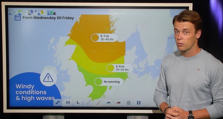
The west to northwest winds will significantly increase in strength from Wednesday over the central and northern parts of the North Sea. Sustained wind speeds will range from 30 to 50 knots locally. Wind gusts are expected to be even higher locally, with the highest gusts anticipated during showers or frontal passages along the southwest coast of Norway.Simultaneously, the waves will also increase significantly in height. Over the far south of the North Sea and along the east coast of England, significant wave heights (Hs) are generally not expected to exceed 2 meters. Further north, the waves will gradually become higher. The highest wave heights are again expected along the southwest coast of Norway, where Hs may locally reach 8 or 9 meters during frontal passages.
.png?width=1083&height=912&name=Wind-Thursday06UTC-w5%20(1).png) Figure 1: Wind speed and wind direction according to ICON on Thursday at 06UTC.
Figure 1: Wind speed and wind direction according to ICON on Thursday at 06UTC..png?width=1049&height=925&name=waves-Thursday06UTC-w5%20(1).png) Figure 2: Significant wave height and wave direction according to ICON on Thursday at 06UTC.
Figure 2: Significant wave height and wave direction according to ICON on Thursday at 06UTC.
Conclusion
The southern North Sea is expected to experience a relatively calm week from a weather perspective, with quite a few workable windows. On the other hand, over the Northern North Sea, strong winds and high waves are forecasted. As a result, there will be few to no workable windows for most operations in that area.
Always up-to-date
Like this weather briefing? Our monthly newsletter gives you even more insights. Tink about the marine weather phenomena, updates about our ever-evolving forecasting products and the latest and most relevant marine weather briefing. Subscribe to receive our Infoplaza marine newsletter once a month.


