A succession of low-pressure systems keeps the North Sea unsettled from Thursday through the weekend, with the northern sectors facing the greatest operational constraints. A transition towards higher pressure after the weekend should improve workability from time to time. Tropical cyclone activity remains relatively limited over both the Atlantic and Pacific this week.
Weather impact
-
Workability: The southern North Sea offers the best workable windows this week, although passing troughs can still temporarily reduce conditions. The northern North Sea experiences the worst conditions. A calm period in the Atlantic and Pacific hurricane/typhoon season results in better working conditions in those areas.
-
Downtime risk: Northern and central sectors of the North Sea face the highest risk of weather-related downtime as successive low-pressure systems move towards Scandinavia. Downtime due to hurricanes or typhoons over the Atlantic and Pacific is limited this week, likely increasing after the weekend.
-
Planning confidence: Conditions should gradually become more favorable after the weekend as high-pressure systems increasingly influence the North Sea.
In short: Offshore operations remain exposed to a changeable pattern this week, but broader and more reliable workable windows are likely to emerge next week.
Operational risk
Operational risk is highest across the northern North Sea, where the strongest winds and highest waves accompany passing low-pressure systems and associated troughs. Viking, Utsire and parts of Forties are most exposed, with shorter workable windows for offshore construction, subsea work and crew transfer. Further south, conditions are generally less restrictive and provide better opportunities between frontal passages.
Weather situation
North Sea
Several low-pressure systems move eastwards from the North Atlantic towards Scandinavia between Thursday and Sunday. Associated frontal troughs repeatedly cross the North Sea, maintaining a changeable south-westerly to westerly flow.
The strongest conditions are expected across northern sectors, where winds can regularly reach 25 - 30 knots during the passage of the more active systems. Significant wave heights increase to around 3.0 - 4.5 meters on Friday over Fair Isle and Viking. Wave heights of 2.5 – 3.5 meters can be expected over Utsire and the northern part of Forties.
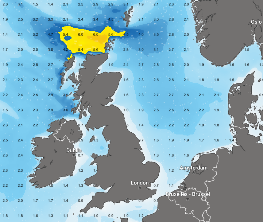 Figure 1. Significant wave height over the North Sea on Friday September 18th at 08:00 UTC.
Further south, the pressure gradient is generally weaker. Winds are more often around 15–25 knots, with significant wave heights mostly between 1.0 and 2.5 meters. This leaves the southern North Sea favorable for workable windows, although timing remains important as frontal troughs temporarily bring freshening winds and higher seas.
After the weekend, the large-scale pattern appears to change. High-pressure systems are expected to have more influence over the North Sea, resulting in a weaker pressure gradient and lower wind speeds. This should support broader workable windows and improve planning confidence for offshore and marine operations.
Atlantic and Pacific
Tropical activity over the Atlantic remains notably limited for the time of year, largely due to the influence of the currently active El Niño over the Pacific. No hurricanes are currently active, although a disturbance over the subtropical Atlantic still needs monitoring for possible development later this week. The absence of this hurricane threat is great news for transatlantic routing.
The Pacific is also relatively quiet this week, although weaker tropical systems remain present. Current activity in the eastern Pacific is expected to remain limited in strength, especially in comparison to last week when three strong hurricanes were active at the same time. After the weekend, however, the broader Pacific pattern appears more supportive of renewed tropical cyclone activity, increasing the need for closer monitoring for marine routing and operational planning.
Conclusion
The North Sea remains unsettled through the weekend, with the greatest operational constraints across Fair Isle, Viking, Utsire and northern Forties. Better workable windows are available further south. From next week, increasing high-pressure influence should bring a more favorable period with lower winds and improved operational continuity across a larger part of the North Sea. The hurricane and typhoon season is not very active this week but is expected to show more activity after the weekend. The Atlantic hurricanes may remain absent, greatly because of El Niño.
Existing Infoplaza customers can use their marine dashboard and monitoring services to follow the latest operational windows and local risk developments. New prospects can contact Infoplaza to explore how marine weather intelligence supports safer planning, fewer disruptions and better operational decisions.