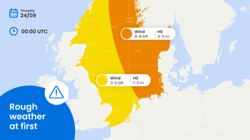
A succession of low-pressure systems gradually takes control of the North Sea from later Wednesday onwards, bringing shorter workable windows towards the weekend. The central and eastern sectors face the greatest operational constraints, while conditions remain more favorable far north. Meanwhile, Invest 92L in the Gulf of Mexico has potential for tropical development later this week and requires close monitoring.
Weather impact
• Workability: the northern North Sea offers the best workable windows, particularly on Wednesday and between frontal passages later in the week. Forties, Dogger, and Humber but also Fisher and German Bight experience the poorest conditions as low-pressure systems move towards Scandinavia.
• Downtime risk: downtime risk increases across the central North Sea from Thursday into Saturday as winds and significant wave heights increase. In the Gulf of Mexico, operational risk could rise quickly if Invest AL92 develops into a tropical depression or tropical storm later this week.
• Planning confidence: confidence decreases from Wednesday afternoon as several low pressure areas and associated troughs cross the area. Development and track uncertainty around Invest 92L also require flexibility for Gulf operations.
In short: Wednesday and late Thursday/early Friday provides the broadest northern North Sea workable window, while low pressure already restricts operations significantly across the central and eastern sectors. Tropical development in the Gulf of Mexico could introduce an additional area of disruption later this week.
Operational risk
Operational risk is highest across Forties, Dogger, and Humber in the central North Sea and Fisher and German Bight in the eastern North Sea. Workable windows become shorter for offshore construction, subsea work and crew transfer. Viking, Utsire and northern Forties remain better positioned, although passing troughs will still temporarily reduce workability.
In the Gulf of Mexico, the main operational uncertainty is the possible strengthening of Invest 92L. Offshore energy operations, supply vessels and marine logistics should maintain sufficient safety margins as conditions could deteriorate quickly if tropical development occurs.
Weather situation
North Sea
From Wednesday afternoon through early Thursday, a low-pressure system moves from the German Bight towards southern Scandinavia. Its associated troughs mainly affect the central and eastern North Sea, increasing the wind and significant wave height over Fisher and German Bight up to 30 knots and 2.5 – 3.0 meters. These highest wind speeds will extend into Utsire later Thursday. With winds around 25 knots and waves around 2.5 meter, conditions are slightly better over the central sectors Forties, Dogger and Humber.
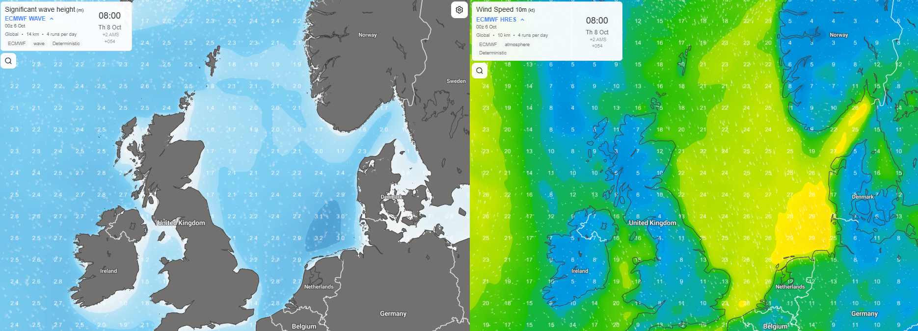 Figure 1. Strong northerly winds and high waves over the eastern North Sea early Thursday October 8th.
A second low-pressure system develops near the Faeroes during Friday before moving towards Viking on Saturday and further into southern Scandinavia on Sunday. Winds are expected to reach around 25 – 30 knots around the first active passing trough. Significant wave heights respond accordingly, with the highest waves across the southern North Sea up to 3.0 meters.
As low pressure crosses the North Sea south-eastwards, winds and waves will further increase on the southern flank of this low-pressure area. Wind speeds are expected to reach 30 – 35 knots, locally higher over the southern Forties/Fisher and northern Dogger/German Bight. Significant waves reach up to 3.0 – 5.0 meters over the southern North Sea.
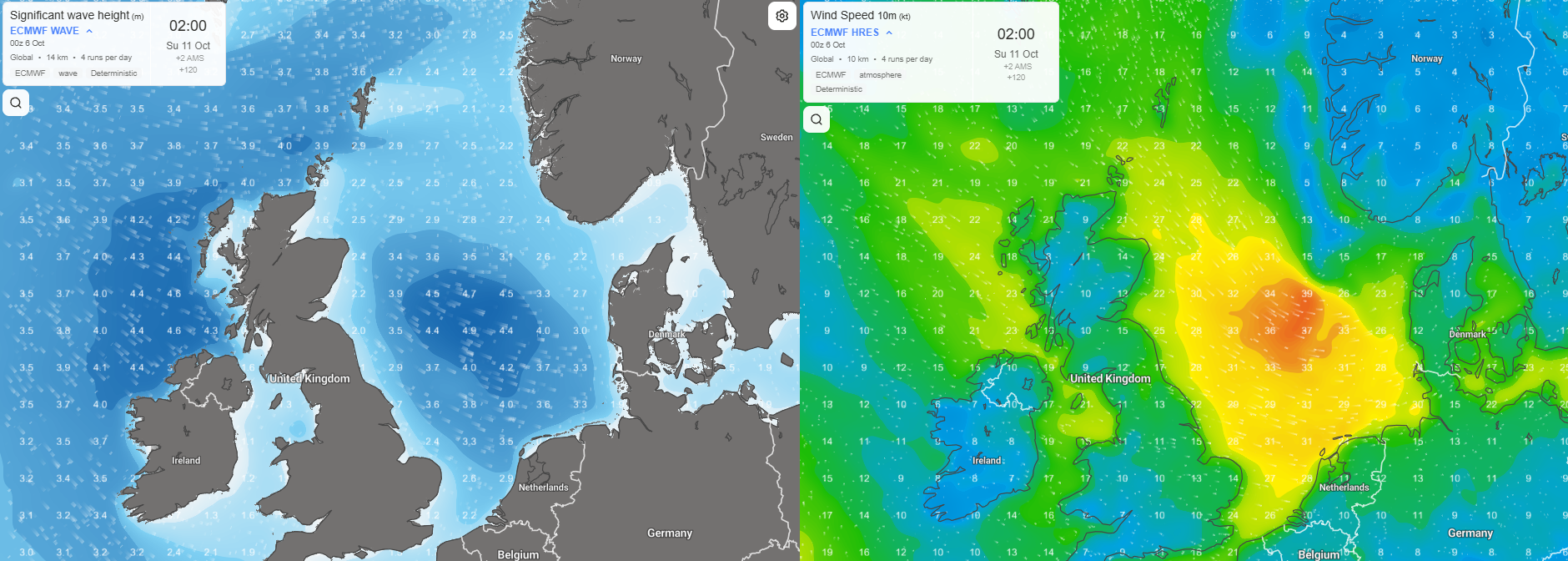 Figure 2. A low pressure area crosses the North Sea with high winds and waves on its southern flank in the night to Sunday October 11th.
On Sunday, low pressure gradually moves away east and weakens and is followed by a ridge of high pressure. Conditions are temporarily expected to improve. However, additional Atlantic low-pressure systems keep the pattern changeable, meaning planning confidence remains low from that moment onwards.
Gulf of Mexico
Invest 92L is the main feature to monitor outside Europe this week. The developing low-pressure area over the southwestern Gulf of Mexico has potential to become better organized as it moves northeast through the basin later this week.
Further strengthening into a tropical depression or tropical storm remains possible. If development occurs, winds and significant wave heights will increase rapidly around the circulation, narrowing workable windows for offshore energy operations, supply vessels and marine logistics.
Track and intensity uncertainty remain significant. Operations across the central and northern Gulf should therefore maintain additional schedule flexibility and safety margins. Any tropical-storm development could lead to a rapid increase in downtime exposure along and near the eventual track.
Conclusion
The North Sea transitions towards a more unsettled pattern from late Wednesday onwards. Forties, Dogger, Fisher and German Bight face the greatest wind and wave exposure from Thursday into Saturday. Better opportunities remain available across the northern North Sea between frontal passages. In the Gulf of Mexico, Invest 92L requires close monitoring as possible tropical development could substantially increase operational risk later this week.
Existing Infoplaza customers can use their dashboard and forecasts to monitor the latest developments and adjust operational planning as conditions evolve. Need more insight into how weather intelligence can support your offshore or shipping operations? Contact Infoplaza to explore the available forecasting and decision-support solutions.