An active low initially limits workability over the North Sea at first, but conditions improve from Thursday as the system moves away and the pressure gradient eases. In the eastern Pacific, Hurricane Polo creates a very different operational picture, with
severe conditions requiring wide safety margins and routing flexibility.
Weather impact
Workability: North Sea conditions improve from Thursday, with the most useful operational
window developing towards Friday and Saturday.
Downtime risk: Wednesday into early Thursday remains less favourable, particularly across
the northern and central North Sea, where the active low brings stronger winds and higher
seas.
Routing: Hurricane Polo creates severe conditions in the eastern Pacific, with substantial
routing deviations and limited schedule resilience near the system.
In short: North Sea operators can increasingly make use of improving conditions later in the
week, while Polo remains a major constraint for marine operations in the eastern Pacific.
Operational risk
The main North Sea downtime risk is concentrated at the start of the period. As the low-
pressure system moves away, conditions become more favourable and broader workable
windows emerge. This supports offshore construction, crew transfer, subsea work and
maintenance later in the week, although developments towards Sunday still need to be
closely monitored.
Around Hurricane Polo, operational risk remains very high. Severe sea state and swell affect a
broad area near the west coast of Mexico. Vessel routing should maintain wide safety
margins, with sufficient flexibility for delays and deviations.
Weather situation
North Sea
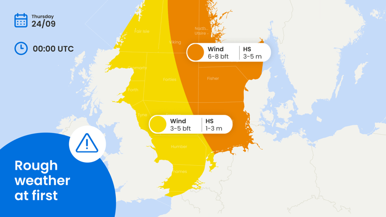
An active low-pressure system initially affects the North Sea, with associated troughs and a
relatively tight pressure gradient. The strongest winds and highest seas are concentrated
across northern and central sectors, temporarily reducing workability on Wednesday and into
early Thursday.
During Thursday, the low moves eastwards and gradually loses its influence. The pressure
gradient eases and conditions improve, allowing workable windows to reopen from later
Thursday onwards. High pressure then builds over the southern North Sea, supporting a more
favourable period into Friday and Saturday.
This provides the main operational opportunity of the week. Weather-sensitive activities can
increasingly be scheduled during the second half of the period, reducing downtime exposure
and improving planning confidence. Towards Sunday, uncertainty increases again and the
forecast still needs to be closely monitored.
Eastern Pacific – Hurricane Polo
Hurricane Polo remains a major marine hazard in the eastern Pacific. Very strong winds and
severe sea state occur around the centre, while heavy swell affects a considerably larger
area.
Polo is expected to move northwestwards, roughly parallel to the southwestern coast of
Mexico. Routing deviations, with wide safety margins and contingency planning are required.
Conclusion
The North Sea shows a clear improvement after the initial period of stronger winds and higher
seas, with the best workable window developing from later Thursday into Friday and Saturday.
Hurricane Polo presents the opposite picture in the eastern Pacific, where severe conditions
continue to restrict routing.
Existing Infoplaza customers can use their marine dashboard and monitoring services to follow the latest operational windows and local risk developments. New prospects can contact Infoplaza to explore how marine weather intelligence supports safer planning, fewer disruptions and better operational decisions.