
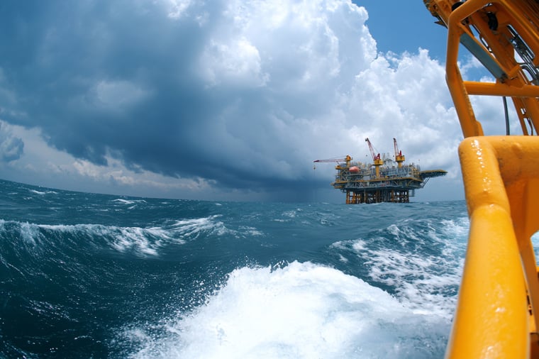
An active Atlantic pressure pattern brings periods of strong winds and elevated wave heights to the North Sea, with the greatest exposure across northern sectors. High pressure improves workable windows across the northern sectors during the weekend, while additional disturbances may limit operational flexibility in the south. Meanwhile, tropical cyclone activity west of Mexico requires close monitoring for potential disruption to Pacific shipping and coastal operations.
Weather impact
-
Workability: The southern North Sea offers the most favourable opportunities during Wednesday, while winds already start increasing. Northern sectors, particularly Fair Isle, Viking and Utsire, face more restrictive conditions. Towards and during the weekend, the northern sectors will get larger workability windows under the influence of high pressure.
-
Downtime risk: Strong winds and residual swell increase downtime exposure for offshore construction, subsea work and crew transfer in the northern North Sea. This will improve during the weekend. Along Mexico's Pacific coast, tropical cyclone activity may affect port access, coastal shipping and marine logistics.
-
Planning confidence: Confidence is higher for the early part of the period and decreases towards the weekend as the timing and positioning of building high pressure over the UK is not yet certain. Tropical cyclone development and movement also require close monitoring.
In short: The southern North Sea offers the best initial workable window, while stronger winds and higher waves constrain northern operations. During the weekend, high pressure improves conditions in the north. Tropical cyclone activity west of Mexico introduces additional risks for Pacific marine operations.
Operational risk
Operational risk is highest across Viking, Utsire and exposed parts of Forties at first, where strong winds and elevated wave heights may restrict offshore construction, lifting operations and crew transfers. Across Dogger, Humber, Fisher and German Bight, conditions are more favourable, although passing troughs may still temporarily reduce workability.
Towards and during the weekend, high pressure over the UK will introduce better working conditions over the northern half of the North Sea, possibly even extending towards the southern North Sea. Unfortunately, models are not yet in agreement about the exact conditions over the southern North Sea.
Along the Pacific coast of Mexico, tropical cyclone activity poses potential risks to coastal shipping, port operations and offshore support vessels. Long-period swell may affect exposed port approaches even where the strongest winds remain offshore.
Weather situation
North Sea
A deep low-pressure system moves northeastwards via Iceland towards the Norwegian Sea on Wednesday, reaching Svalbard by Friday afternoon. It is expected to bring (near) gale-force winds across Fair Isle, Viking and North Utsire late Wednesday and early Thursday. Associated frontal troughs cross the northern and central sectors. Winds freshen to around 30 – 35 knots, locally higher in exposed northern areas. Significant wave heights may reach between approximately 3.5 and 5.0 meters. The southern half of the North Sea will experience better conditions with 20 – 30 knots and 1.5 – 3.0 meters.
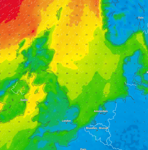 Figure 1. Near gale to gale force winds over the northwestern part of the North Sea on Wednesday 22:00 UTC.
During late Thursday and early Friday, conditions ease somewhat during the passage of a cold front, reducing the pressure gradient in most sectors. Residual swell may continue to restrict sensitive offshore activities.
On Friday, another increase in winds is expected as the pressure gradient tightens again as high pressure builds over the UK and low pressure strengthens over southern Sweden. Winds are expected to reach strong to near gale force in many central and eastern sectors (mainly South Utsire, Fisher, German Bight and the eastern parts of Forties and Dogger). High winds and waves extend into Saturday, reaching 25 – 30 knots and 2.5 – 4.0 meters.
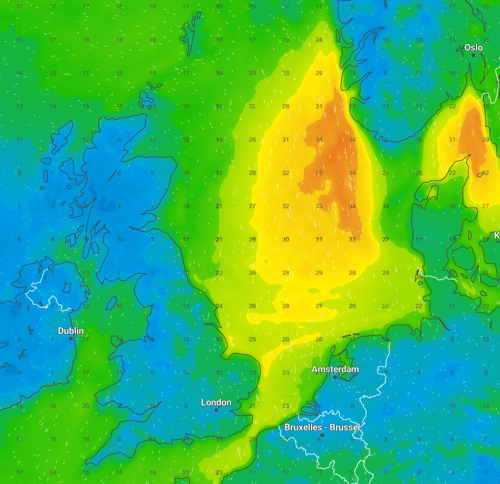 Figure 1. Strong to near gale force winds over the central and eastern parts of the North Sea on Saturday 10:00 UTC.
From Sunday through Tuesday, the influence of high pressure is expected to provide further opportunities for offshore operations, especially in the northern and partly central sectors. The development of additional disturbances over mainland Europe remains uncertain and decreases the confidence for the southern North Sea by then.
Eastern Pacific: Hurricane Simon and further tropical development
Hurricane Simon is currently affecting the eastern Pacific near Mexico. On Wednesday, the system is slow-moving offshore of west-central Mexico, with sustained winds around 75 knots. It is expected to move gradually north on Thursday and Friday, making landfall during the weekend over the province of Sinaloa. Heavy rainfall and hazardous marine conditions continue to affect exposed coastal areas the coming days. This restricts coastal shipping, port operations and offshore support activities, particularly along exposed sections of Mexico's western coastline.
Further tropical development is expected later this week. Invest EP93, well south of Mexico, is expected to develop into a tropical storm anytime soon, moving in a northerly direction the coming days. It is expected to approach the Mexican coastline of the Guerrero province on Friday, moving NW along the coastline in the days after. This system requires continued monitoring for any operations in the area.
Conclusion
The North Sea remains changeable, with the greatest operational constraints across Viking, Utsire and Forties at first, and over the eastern sectors later this period. High pressure will improve conditions from the north during and just after the weekend. In the eastern Pacific, Hurricane Simon and the potential for further tropical development require close monitoring, particularly for shipping and port operations along Mexico's western coastline.
Existing Infoplaza customers can use their dashboard and forecasts to monitor the latest developments and adjust operational planning as conditions evolve. Need more insight into how weather intelligence can support your offshore or shipping operations? Contact Infoplaza to explore the available forecasting and decision-support solutions.