Synoptic overview
A low-pressure system is located above southern Scandinavia and is moving southeastward. The associated front will later today (Tuesday) cross the southern North Sea towards the southeast. Behind it, a temporary weak high-pressure area will form over the North Sea, particularly on Wednesday, bringing relatively calm weather. From Thursday onwards, a complex low-pressure system will reach the British Isles. On Thursday and Friday, there might be the formation of small secondary lows over the North Sea, making the forecast for that period uncertain. However, it is certain that from Thursday, the weather will become quite unsettled for a few days with sometimes high waves and strong winds.
The low over the British Isles will move southeastward during the weekend. High pressure will build up from the Atlantic Ocean towards the North Sea, leading to less unsettled weather. However, due to the northern flow, it remains uncertain whether the waves will decrease enough to fall below workable limits.
Wind and waves
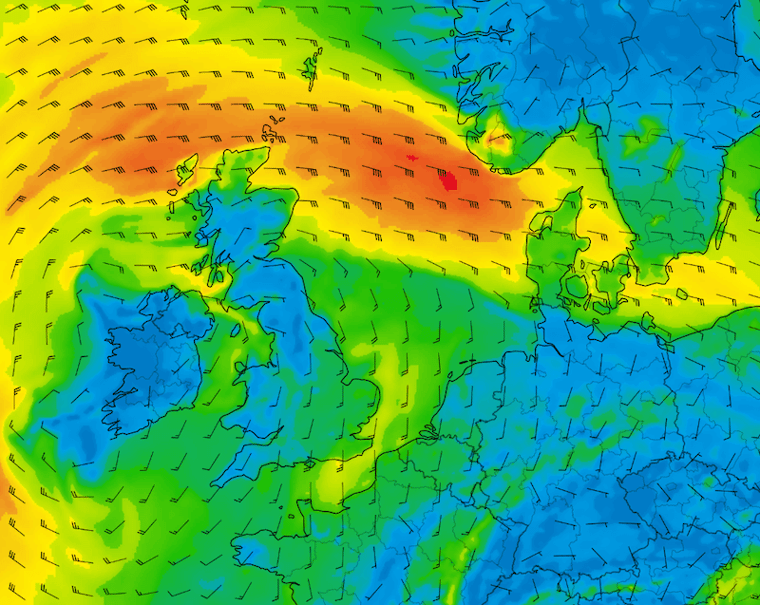
Figure 1 shows the wind speed and wind direction according to the American weather model GFS. The high-pressure area that temporarily lies over the North Sea on Wednesday briefly brings stable weather. Over the southern North Sea, the average wind speed barely exceeds 4 Beaufort. In the middle and northern parts of the North Sea, the northwesterly wind blows a bit stronger, reaching force 5-6.
At the same time, the significant wave height (Hs) is relatively low. Due to the calm weather over the southern North Sea, Hs is expected to barely exceed 2 meters in this area. Further to the north, where there is more wind, the significant wave height will be slightly higher, around 3 meters.
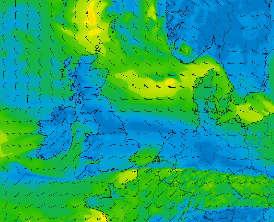 Figure 1: Wind speed and wind direction according to GFS on Wednesday at 12 UTC.
  Figure 2: Significant wave height (Hs) and wave direction according to GFS on Wednesday at 12UTC.
After Wednesday, this calm weather quickly changes. A low-pressure system settles over the British Isles, and associated troughs move across the North Sea. Locally, small secondary lows contribute to even more active weather. North of the low, a strong east to southeast wind develops over the northern North Sea (Figure 3). The wind can be locally stormy. Further south, the conditions are calmer.
Due to the strong wind, the waves will significantly increase in height. Especially over the northern North Sea, due to the southeast direction of the wind, there is a relatively long fetch (Figure 4). As a result, Hs is expected to rise to 5m in many areas there. The highest values are forecasted in the area between Norway and Scotland. Further south, Hs gradually decreases. Over the southern North Sea, Hs often ranges between 2-3m. Due to the southern direction of the wind and waves in that area, the German Bight remains sheltered, keeping Hs there often below 2m. 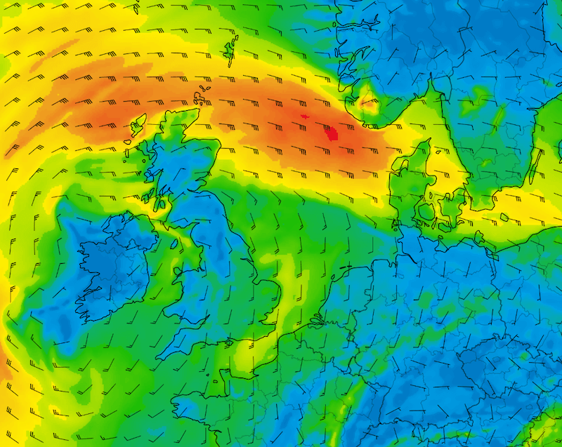 Figure 3: Wind speed and wind direction according to GFS on Friday at 18UTC.
 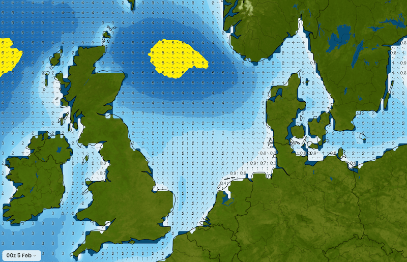 Figure 4: Significant wave height (Hs) and wave direction according to GFS on Friday at 18UTC.
Conclusion
After the front passage over the southern North Sea on Tuesday, many places will experience temporary calm due to a small high-pressure area. Especially on Wednesday, there will be workable windows in many locations. From Thursday onwards, it becomes unsettled again, and the wind significantly increases in strength, leading to a considerable rise in significant wave height (Hs). Especially over the Northern North Sea, workability may be limited. However, operations in the German Bight might continue due to its sheltered position during the usually southerly wind on Friday.Always up-to-date
Like this weather briefing? Our monthly newsletter gives you even more insights. Think about the marine weather phenomena, updates about our ever-evolving forecasting products and the latest and most relevant marine weather briefing. Subscribe to receive our Infoplaza marine newsletter once a month.


