A northwesterly flow brought colder air towards the North Sea, with plenty of wintry showers. It remains wintry the coming days, but a gradual change to a milder type of weather is about to happen. Low pressure over Scandinavia and the Norwegian Sea will gradually shift east, while high pressure over the Atlantic will gradually settle over central Europe. This will allow Atlantic low pressure to move into Northwest Europe. The northwesterly winds will gradually be replaced by southwesterly winds. Unsettled conditions are expected to persist from time to time.
Synoptic overview
Low pressure areas were predominantly present over Scandinavia and the Norwegian Sea the last few days, while high pressure lingered over the northern Atlantic Ocean. This pressure distribution is about to change by the end of the week. A secondary low pressure, belonging to low pressure over the Norwegian Sea, passes the central North Sea from west to east late Tuesday and early Wednesday. By then, another low pressure area is present over the Bay of Biscay, moving east into France on Wednesday. This low pressure moves towards northern Italy on Thursday, while Atlantic high pressure moves southeast towards the Bay of Biscay. Low pressure still lingers over the Norwegian Sea in the meantime, maintaining the cold northwesterly flow. Low pressure weakens on Friday as it slowly moves east into Scandinavia, while high pressure moves east into France. An associated mobile ridge shifts across the North Sea that day. In the wake of this ridge, winds become southwesterly, as new strong Atlantic low pressure is ready to call the shots from coming weekend onwards.Wind and waves
The steady northwesterly flow weakens today, resulting in calmer condition. Moderate to fresh winds dominate most of the North Sea, 4-5 Bft, sometimes reaching just into 6 Bft. However, in the late afternoon and evening, a secondary low shifts east across the North Sea (roughly between 55N and 57N). On the southern flank of this low, the wind is expected to reach 6-8 Bft, temporarily and very locally up to 9Bft just south of the low pressure core. Significant wave height fluctuates mostly between 2 and 3 meter over the central and northern North Sea. On the southern flank of the secondary low, waves temporarily increase to up to 4 meter (Figure 2).Mostly moderate to strong (3-6 Bft) west-northwesterly winds continue over the North Sea on Wednesday, with strongest winds over Fair Isle, Forties, Dogger and the regions adjacent to Scotland (locally even up to 7 Bft). The northwesterly wind picks up again on Thursday, reaching 5-7 Bft in the morning and 6-8 Bft later that day. Significant waves will gradually increase, reaching between 3 and 4 meter in general. The southern North Sea will experience lower wave heights mostly between 2 and 3 meter.
The American GFS model calculates another low pressure crossing the northern North Sea early on Friday, which is not supported by the European ECMWF model. The confidence is low for this period. If the GFS scenario becomes reality, winds will pick up into 9 Bft on its southern flank and waves between 4 and 5 meter over the northern part of the central North Sea. During the weekend, more low pressure is expected to reach the North Sea. Widespread gale force winds are expected with the significant wave height reaching between 3.5 and 4.5 meter. Please note that the exact position and track of these low pressure areas are still uncertain.
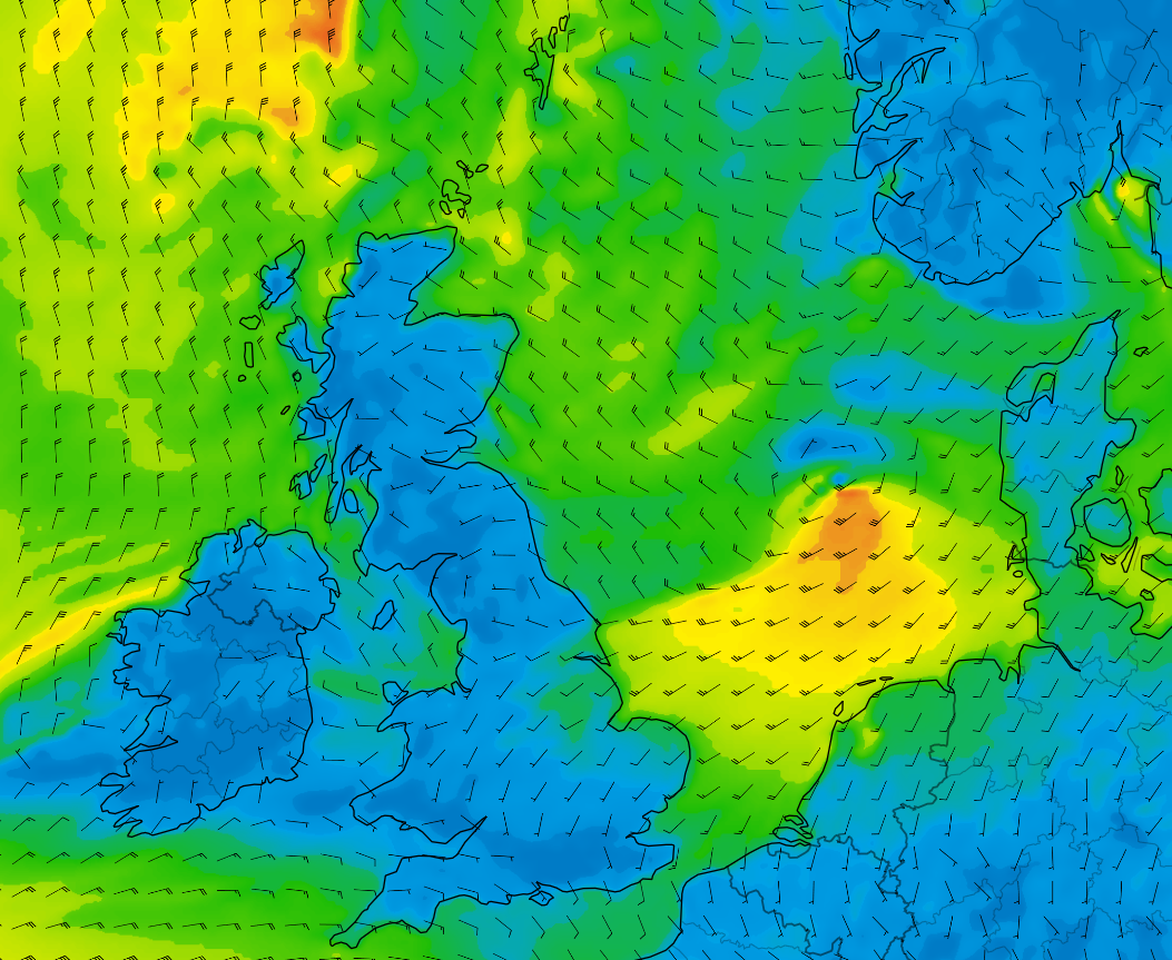 Figure 1: Wind speed and wind direction according to GFS on Wednesday at 00 UTC.
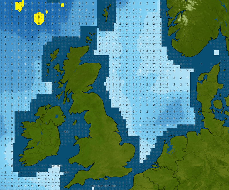 Figure 2: Significant wave height and wave direction (wave model based on GFS) on Wednesday at 00 UTC.
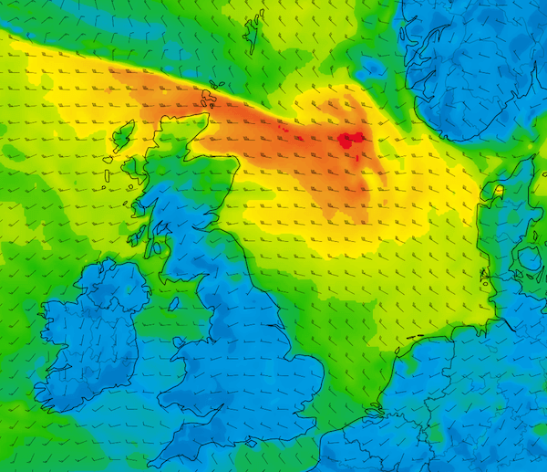 Figure 3: Wind speed and wind direction according to GFS on Friday at 06 UTC.
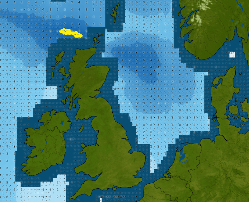 Figure 4: Significant wave height and wave direction (wave model based on GFS) on Friday at 06 UTC.
Conclusion
This week remains unsettled over the North Sea in general, due to low pressure over Scandinavia and the Norwegian Sea. However, there is a significant shift happening in the pressure distribution by the end of the week. The unsettled conditions continue from next weekend onwards, but with predominantly southwesterly winds instead of the northwesterly winds earlier in the week.Always up-to-date
Like this weather briefing? Our monthly newsletter gives you even more insights. Think about the marine weather phenomena, updates about our ever-evolving forecasting products and the latest and most relevant marine weather briefing. Subscribe to receive our Infoplaza marine newsletter once a month.