Spring has officially started, but we still have to wait for stable and calm spring weather over the North Sea. A complex low pressure area continues to linger close to Ireland in the coming days, resulting in slightly unsettled conditions over the North Sea this week. By the end of the period, low pressure tends to shift more toward mainland Europe.
Synoptic overview
Low pressure dominates just south of Ireland and just northwest of the Iberian peninsula today. The latter will gradually dissipate over Spain tonight, while the former will turn counterclockwise over Ireland while merging with next frontal trough coming from Greenland. This merged low- pressure area is expected to linger close to or over Ireland until the end of the week. During next weekend, it is expected to gradually dissipate.Video briefing at the and of this article
While this low-pressure area is not expected to cross the UK into the North Sea, several associated frontal troughs are expected to bring unsettled conditions in the North Sea region. A small-scale secondary low develops just east of Scotland later today, tracking north towards the Shetlands before dissipating tomorrow. It is directly followed by another frontal trough crossing the western-central and northern North Sea tomorrow. Two more troughs are forecasted for Thursday, gradually shifting from south to north across the North Sea. Conditions are likely to improve over much of the North Sea during the weekend as low pressure moves southwestward, approaching another low-pressure system near Portugal. By then, another low-pressure area is likely to develop over the Benelux region, moving northward towards Norway. High pressure is expected to build near Greenland by that time.
Wind and waves
Despite the dominating presence of low pressure near Ireland, its influence does not extend across the entire North Sea. Primarily, the northern and western parts of the North Sea are affected, while the eastern North Sea remains relatively quiet. The main issue with this lingering low-pressure system is the uncertainty it introduces into the forecasts over the North Sea this week. Several passing frontal troughs will increase wind and sea conditions from time to time. Pinpointing the exact timing and trajectory of these troughs is a challenge.The previously mentioned small-scale secondary low today is expected to enhance wind and waves locally over the northern North Sea. Strong winds are expected, potentially reaching near gale force for brief periods. Significant wave heights are expected to exceed 3.0 m around the core of the low-pressure system, with some models even indicating waves over 3.5 meters. The rest of the North Sea is not affected much by this low-pressure area today, with moderate to fresh winds and significant wave heights ranging from 1 to 2 meters.
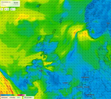 Figure 1: Wind speed in knots according to the American GFS model on Tuesday March 26th at 18 UTC.
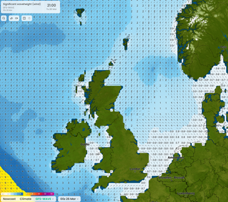 Figure 2: Significant wave height in meters according to the American GFS wave model on Tuesday March 26th at 21 UTC.
On Wednesday, the influence of low pressure increases slightly. Strong to near gale winds are expected over the northern North Sea, while winds also begin to strengthen to strong over the western part of the central and southern North Sea. Significant waves are expected to rise locally to 3-4 meters over the northern North Sea and up to 2 meters over the western North Sea. During Thursday, wind and wave conditions are expected to improve over the northern North Sea (a deviation from yesterday’s model runs, highlighting the forecast’s uncertainty), while winds continue to intensify over the central and southern North Sea. Winds are expected to reach strong to near gale force with significant wave heights reaching around 3.0 meters. On Friday, conditions will slowly improve again over the central and southern North Sea, while winds strengthen once more over the northern North Sea. Significant waves are expected to again reach heights of 3-4 meters.
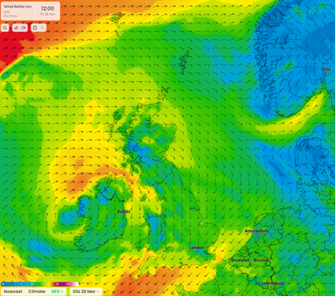 Figure 3: Wind speed in knots according to the American GFS model on Thursday March 28th at 12 UTC.
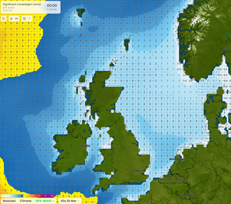 Figure 4: Significant wave height in meters according to the American GFS wave model on Friday March 29th at 00 UTC.
The eastern part of the North Sea, roughly east of 05E, experiences lesser impact from low pressure. Favorable conditions can be expected in this area until late Thursday, with mostly moderate to occasionally fresh winds and significant waves fluctuating between 0.5 and 1.5 meters. On Friday, winds are likely to increase to strong, reaching 6 Beaufort. Significant wave heights are expected to surpass 2.0m in many places. After a very brief intermezzo, another low- pressure area may develop over the German Bight on Saturday, potentially reintroducing the strong winds quickly.
The remainder of the North Sea will see improving conditions throughout the weekend as the pressure pattern relaxes. Winds will be mostly moderate over the central and southern North Sea, sometimes reaching up to fresh over the northern North Sea. Wave heights will gradually decrease as well, dropping to around 1.0 meter over the central and southern parts and around or just below 2.0 meters over the northern North Sea.
Conclusion
The general synoptic situation this week is relatively straightforward, with low pressure remaining almost stationary near Ireland for several days. However, this presents difficulties in forecasting the timing and positioning of passing frontal troughs over the North Sea. The northern and western regions of the North Sea will be most affected by low pressure, while the eastern part is expected to experience favorable conditions during the initial days.
Always up-to-date
Like this weather briefing? Our monthly newsletter gives you even more insights. Think about the marine weather phenomena, updates about our ever-evolving forecasting products, and the latest and most relevant marine weather briefing. Subscribe to receive our Infoplaza marine newsletter once a month.