Low-pressure, with an associated frontal trough, moves east across the North Sea on Tuesday. Afterwards, high-pressure over the Bay of Biscay moves east and settles over France for the rest of the week. An associated ridge affects mostly the southern North Sea, bringing relatively calm weather. A frontal trough trails over the central and northern North Sea at the same time, resulting in a more unsettled weather.
Synoptic overview for week 40, 2023
A frontal trough, together with associated low-pressure area, is tracking eastward via the North Sea on Tuesday. The low-pressure area moves further east into Scandinavia and the Baltic Sea on Wednesday.By then, a high-pressure area over the Bay of Biscay moves east, settling over France (1030 hPa). An associated ridge stretches over the southern North Sea. At the same time, weak low-pressure moves into the Norwegian Sea. An associated frontal trough trails over the central and northern North Sea on Wednesday, declining on Thursday, as the ridge extends further to the north. A new frontal trough affects the central and northern North Sea on Friday.
The frontal trough is associated with an Atlantic Low, approaching gradually from the west during the weekend. The high-pressure area over France is expected to move to the east during the weekend, with the associated ridge gradually leaving the North Sea area. The Atlantic low-pressure area lingers between Iceland and Scotland by then.
Wind and waves
A strong westerly breeze is expected over the majority of the North Sea on the frontal passage on Tuesday. And on Wednesday. Waves will build towards 2.5 – 3.0 meters later on Tuesday and on Wednesday. Over Fisher and Skagerrak, waves are expected to increase slightly further, up to 3.5 meters. Because the wind is of westerly direction, the sheltering effect of the British Isles comes into play (short fetch). Waves along the British coastline will generally not exceed 1.5 meters.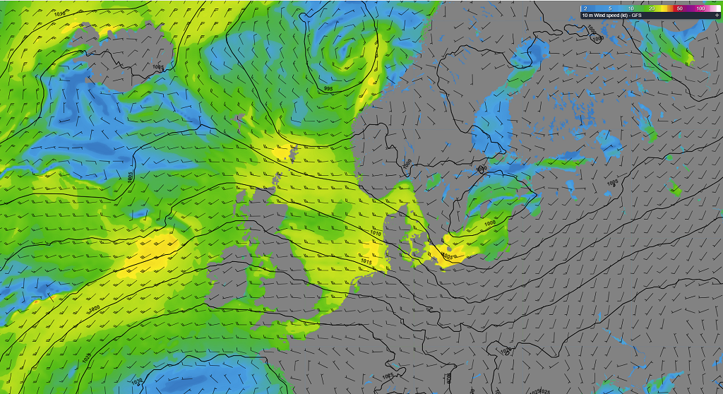 Figure 1: Isobars and wind speed and wind direction on Tuesday 3rd of October, 18 UTC (GFS).
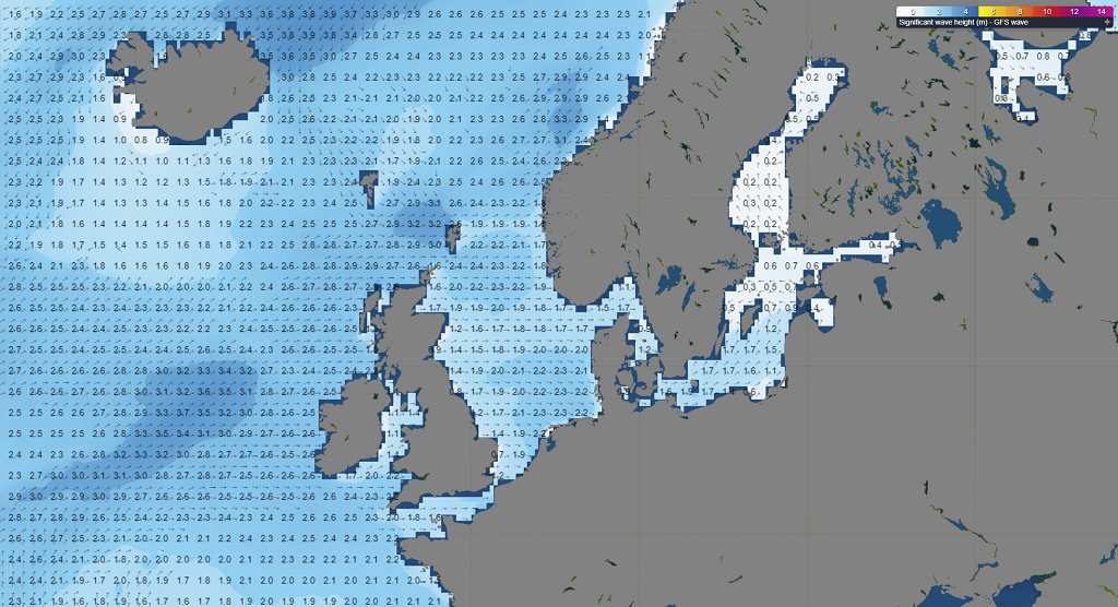 Figure 2: Wave height and direction on Tuesday 3rd of October, 18 UTC (wave model, based on GFS).
Winds and waves will decrease over the North Sea area on Thursday, due to an increasing influence of the ridge of high-pressure. Winds will decrease to a moderate to fresh breeze (10 – 20 kts). The significant wave height is expected to decrease to 1.0 – 2.0 meter. Most winds and highest waves are again expected over Fisher and Skagerrak (20-25 kts , 2.0-2.5 meters Hs). The far west of the North Sea still experiences the sheltering effect; waves are not expected to exceed 1.0 meter.
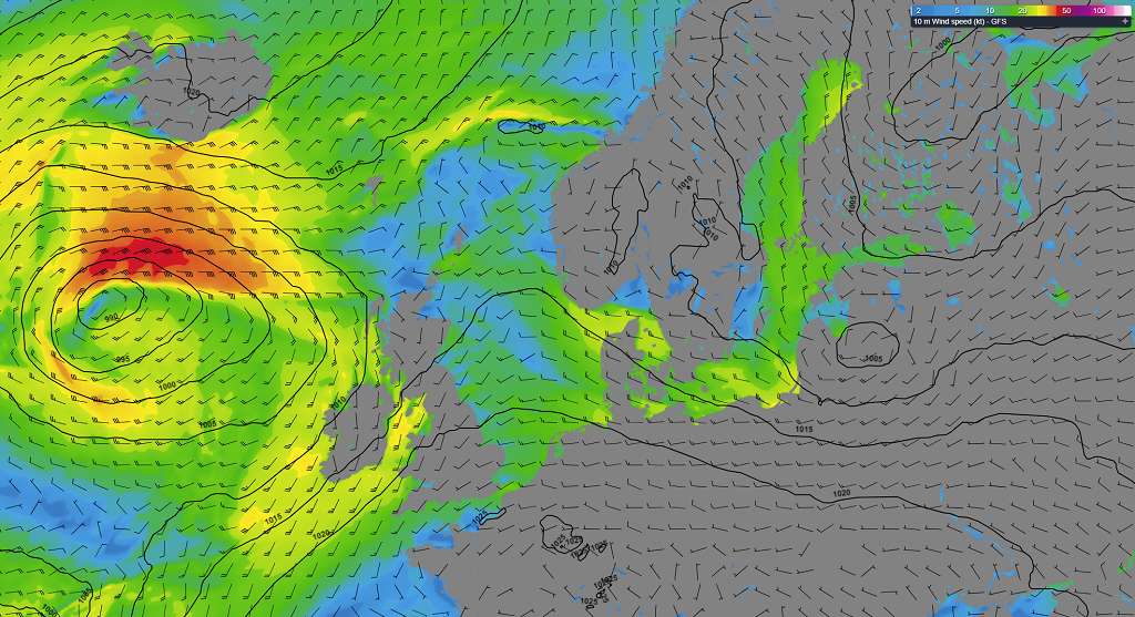 Figure 3: Isobars and wind speed and wind direction on Thursday 5th of October, 15 UTC (GFS).
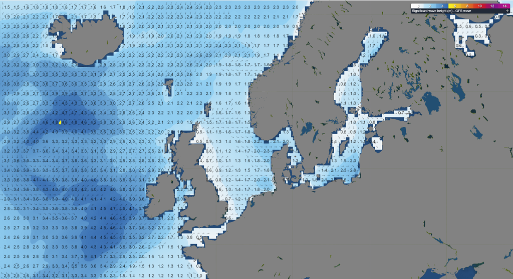 Figure 4: Wave height and direction on Thursday 5th of October, 15 UTC (wave model, based on GFS).
Winds are expected to increase again to a fresh to strong breeze from the south on Friday, furthermore backing towards the southwest. Waves increase up to 2.0 meters. During the weekend, most is expected over the central and northern North Sea, possibly reaching near gale force (25 – 30 kts). Waves can build up to 3.0 meters.
Conclusion
A low-pressure area, together with an associated frontal trough, moves east across the North Sea on Tuesday. Afterwards, high-pressure over the Bay of Biscay moves east and settles over France for the rest of the week. An associated ridge affects mostly the southern North Sea, bringing relatively calm and workable weather. A frontal trough trails over the central and northern North Sea on Wednesday, resulting in a more unsettled weather. On Thursday, winds and waves will decrease, bringing more workable windows. Towards and during the weekend, winds will increase again. Highest winds and waves are expected over Fisher and Skagerrak this week, while the westerly air flow results in the sheltering effect along the east coast of the British Isles.Learn more about the weather
We just launched our new resources page. Here you will find special content like videos, webinars and whitepapers that will guide you to a decision point. Use these expert insights to improve your business or simply to get your knowledge about marine weather up-to-date.