Several low-pressure areas will move across the southern North Sea in the coming days. These low-pressure areas will once again bring unsettled weather to large parts of the North Sea. By Wednesday, the weather temporarily stabilizes due to a ridge of high pressure building over the North Sea. A new front crosses the North Sea on Thursday but dissipates quickly. Afterward, an extensive high-pressure system over the Bay of Biscay expands over the southern North Sea. Particularly in this area, this high-pressure system leads to significantly less unsettled weather during the weekend.
Synoptic overview
Low pressure is located above the UK. This low is moving over the southernmost part of the North Sea towards the Netherlands on Wednesday. At the same time, a weak ridge of high pressure is building over the Northern North Sea. This ridge moves southeastward later on Wednesday and early Thursday. By that time, an active low-pressure system is located near Iceland. An associated trough, gradually filling, moves across the North Sea on Thursday. Simultaneously, a large high-pressure system builds up over the Bay of Biscay. Its associated ridge lies over the North Sea during the weekend. This strong high-pressure system leads to a decrease in unsettled weather.Video briefing at the end of this article
Wind and waves
A low-pressure area is situated above the southern part of the North Sea, as shown in Figure 1. To the south of the low, a southwest wind is blowing, while to the north of the low-pressure center, a fairly strong east wind (force 6) is prevailing. Due to the strong wind and a relatively long fetch, the highest waves occur in this area. The significant wave height is often around 3 meters. Particularly along the east coast of England, Hs sometimes exceeds 3 meters (Figure 3). As the low moves southeastward later on Wednesday, both the wind and waves will decrease.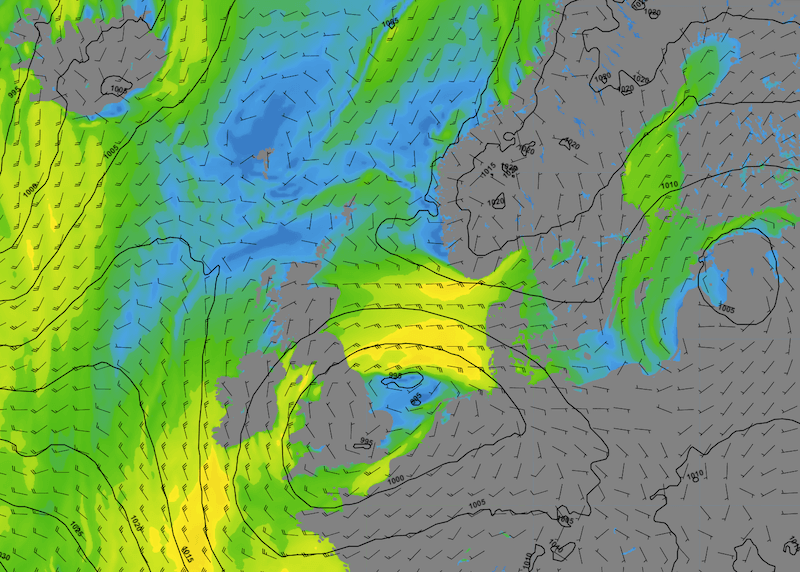 Figure 1: Wind speed and wind direction according to GFS on Wednesday at 00UTC.
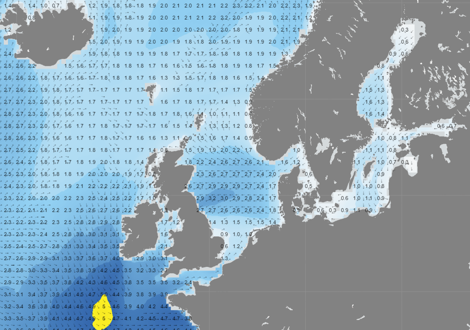 Figure 2: Wave height and wave direction according to GFS on Wednesday at 00UTC.
As described in the synoptic description, a ridge is expected to move from north to south over the North Sea later on Wednesday. This will temporarily stabilize the weather. A weak front on Thursday will cause a slight increase in wind and waves, but no more than 2 meters of significant wave height is anticipated. Starting from Friday, a large high-pressure system will move from the Bay of Biscay towards the southern North Sea (Figure 3). This will lead to a gradual decrease in significant wave height (Hs). In the extreme southern part of the North Sea, Hs is often no more than 0.5-1 meter, while farther north, Hs is expected to increase to 3-4 meters along the southwest coast of Norway (Figure 4).
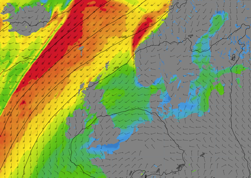 Figure 3: Wind speed and wind direction according to GFS on Saturday at 00UTC.
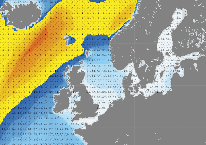 Figure 4: Significant wave height and wave direction according to GFS on Saturday at 00UTC.
Conclusion
A low-pressure area above the southern North Sea, especially during Tuesday and Wednesday, introduces uncertainty and an increase in wind and waves, particularly just north of the low-pressure center. A weak high-pressure ridge brings more stable weather into the night towards Thursday. Truly stable conditions are expected over the weekend due to an extensive high-pressure system above the far southern North Sea. Specifically in that area, both the wind and waves will significantly diminish, creating numerous workable windows.
Always up-to-date
Like this weather briefing? Our monthly newsletter gives you even more insights. Think about the marine weather phenomena, updates about our ever-evolving forecasting products and the latest and most relevant marine weather briefing. Subscribe to receive our Infoplaza marine newsletter once a month. 


