Weather conditions will be relatively calm on Tuesday, but they will quickly deteriorate on Wednesday as a frontal trough tracks northeastward over the North Sea. Meanwhile, a deep low-pressure area (storm Ciarán) forms rapidly over the Atlantic Ocean and races towards the UK in the night to Thursday. The low-pressure system fills over the North Sea afterwards. Another deep low-pressure core reaches the North Sea on Saturday.
Synoptic overview week 44, 2023
High pressure (1019 hPa) is located over the Norwegian Sea and extends a ridge south along the east coast of the UK on Tuesday. The ridge dissipates as a frontal trough reaches the southern North Sea in the night leading into Wednesday. An associated low-pressure core (977 hPa) is located west of Ireland. As the frontal trough tracks northeastward over the North Sea, a secondary low pressure core forms southwest of Ireland. The system intensifies rapidly into storm Ciarán and reaches the UK during the night leading into Thursday with a core pressure of 951 hPa. The low subsequently moves into the North Sea on Thursday and starts to weaken. A new low-pressure area forms over the Atlantic Ocean and deepens rapidly as well. This new low reaches the North Sea later on Saturday with a core pressure of 959 hPa, once again resulting in strong winds and high waves.You can find the video briefing at end of the article
Wind and waves
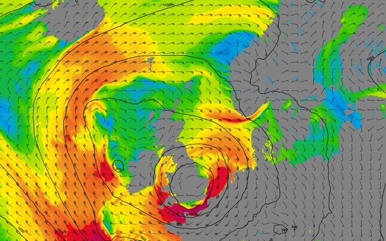
Most active weather during this week will be associated with the deep low-pressure cores mentioned above. The first one, storm Ciarán is expected to arrive over the far south of the UK in the night leading into Thursday . There is still some uncertainty among various numerical weather models regarding the exact location and intensity of Ciarán. As a result, the location where the most active weather is forecasted varies a somewhat between those numerical weather models.In general, waves are expected build up to 3-5 meters over a large part of the North Sea on Thursday (Figure 2), accompanied by sustained winds of 35-40 kts, with local gusts reaching 60-70 kts (Figure 1).
Within the core of the low-pressure area, both wind and waves expected to be relatively calm. However, it is difficult to pinpoint the exact location of the core of the storm on Thursday. The highest changes for a brief calm period during the passage of the storm’s core will be along the east coast of the UK.
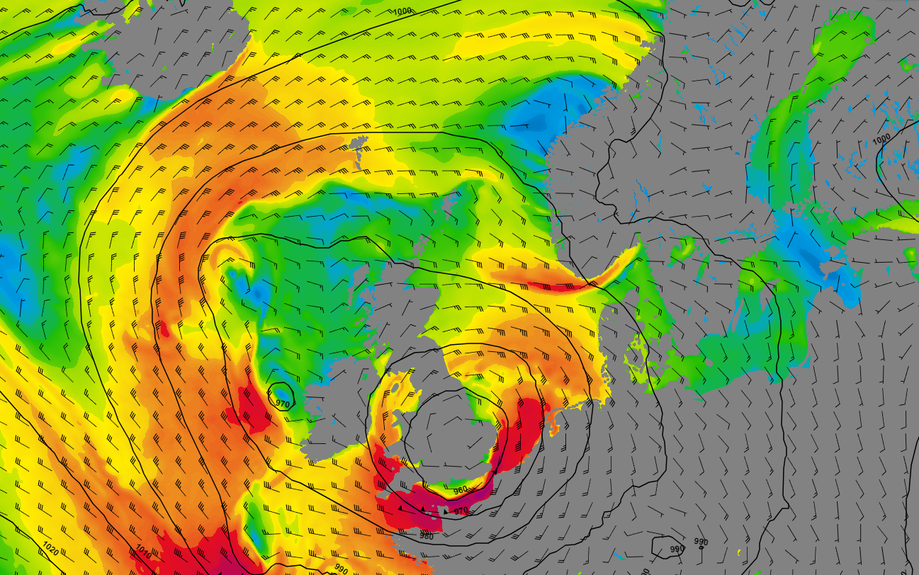 Figure 1: Wind speed and wind direction on Thursday at 12 UTC according to the GFS model.
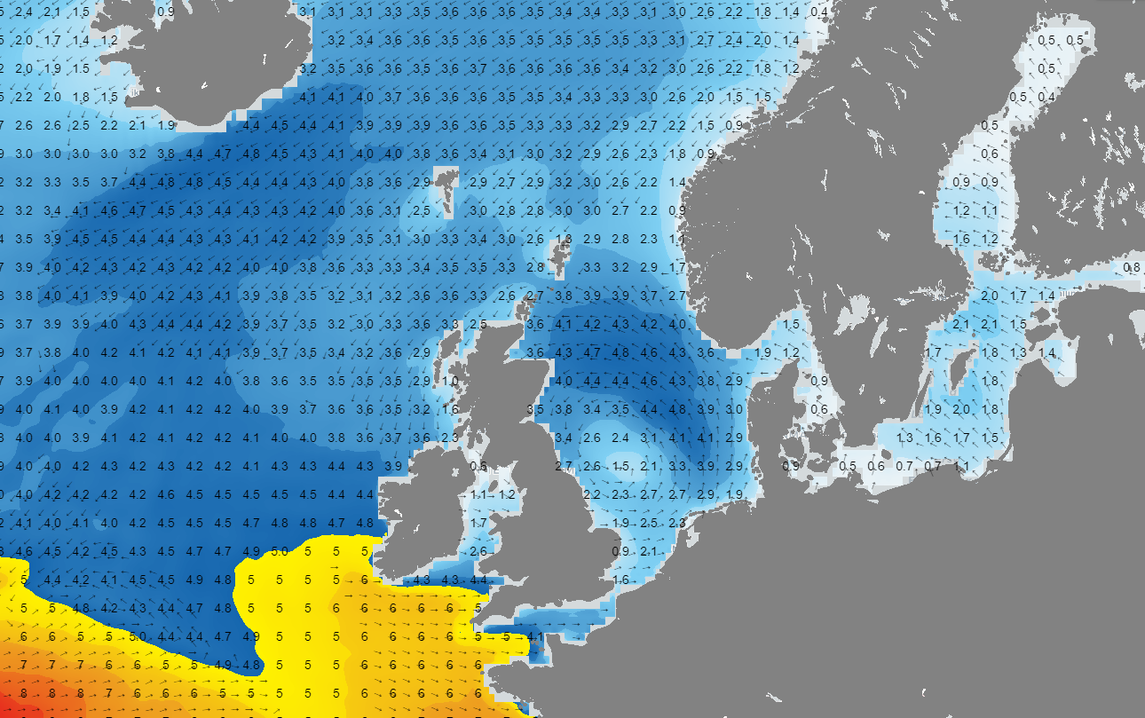 Figure 2: Significant wave height and wave direction over the North Sea on Thursday at 12 UTC according to the GFS model.
The next major low-pressure area reaches the North Sea on Saturday. The core pressure of this system will be very low again (around 959hPa) when it enters the North Sea from the southwest. This likely results again in strong winds, high waves, and a lot of precipitation. Both wind speed and significant wave height are again lower in the core of the storm due to a lack of pressure gradient (Figure 3). The highest wind speeds (up to 30-35 kts) are forecasted over the eastern half of the North Sea (Figure 3).
 Figure 3: Wind speed and wind direction on Saturday at 12UTC according to the GFS model.
Although the core pressure of the system is very low, the pressure gradient is expected to be weaker compared to the system which will enter the North Sea on Thursday. As a result, significant wave height will likely be lower as well. The highest Hs will be forecasted over the eastern half of the North Sea where winds are the strongest. Hs will likely reach values op to 3 meter over there (Figure 4). Hs will be lower (around 1-2 meter) over the western half of the North Sea due to a weaker pressure gradient (Figure 4).
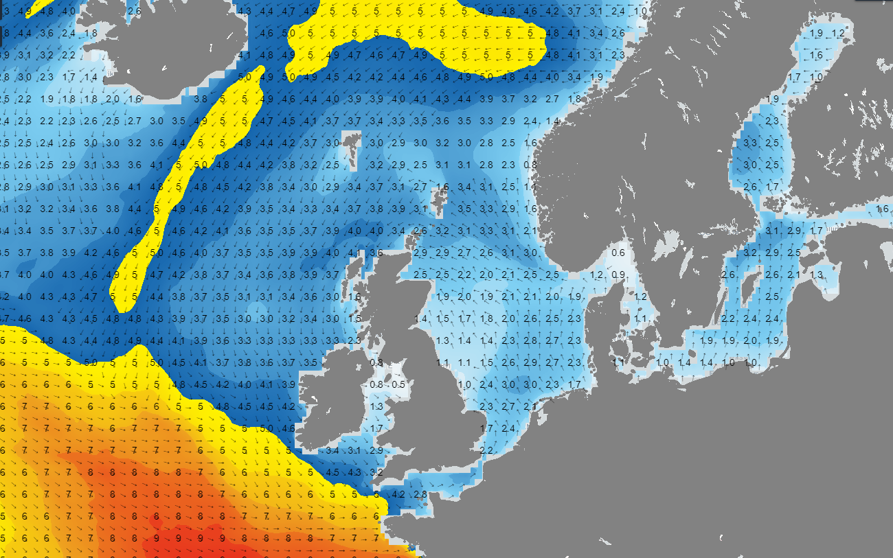 Figure 4: Significant wave height and wave direction on Saturday at 12UTC according to the GFS model.
Conclusion
Low-pressure areas will dominate the North Sea during a large part of the week. The most active low, storm Ciarán, will reach the North Sea on Thursday, resulting in strong winds and high waves. A second major low reaches the North Sea on Saturday, but it will be a bit less strong compared to the one on Thursday. However, both systems will bring a lot of precipitation.
Learn more about marine weather
We just launched our new resources page. Here you will find special content like videos, webinar and whitepapers that will guide you to a decision point. Use these expert insights to improve your business or simply get your knowledge about the marine weather up-to-date.