Just like last week, this week’s weather charts show a blocked pattern unfolding over large parts of Europe, including the North Sea area; with northern high pressure and Atlantic influences being placed along the sidelines. Even though blocked patterns usually yield prolonged periods of stable weather, this is not the case for this week. You can read all about it in this week’s weather blog.
Synoptic situation
A blocking high tracks E across Scandinavia on Tuesday and Wednesday, expected to move into Russia during the second half of the week. An associated ridge stretches SW towards the North Sea at first, slowly retreating NE before leaving the N North Sea in the course of Wednesday.At the same time shallow low pressure is predominant over large parts of the European mainland. Several small-scaled centers wander around at first, but as the upper air gets increasingly conductive for deepening an elongated low develops over Germany and parts of the Benelux later on Tuesday, before moving NW across the North Sea on Wednesday and Thursday. The system ends up just E or near Scotland on Friday, by then gradually dissipating. Fig 1. Wednesday 00z. Left: High pressure over Scandinavia with, on its southern flank, a deepening low over the European mainland. Right: associated frontal trough entering the S North Sea
Associated frontal trough is being dragged along to the N across the North Sea, separating warm and stable air on its northern flank from cooler maritime air to the south. Expect mist and some fog patches near the frontal trough and the parenting low, as well as showery outbreaks, possibly accompanied by thunder.
Coming weekend high pressure rebuilds over the North Sea in the wake of the low, calming things down again. Later on, a weakening Atlantic trough draws closer to the North Sea from the W, gaining influence over the area in the course of Sunday.
Wind and waves
Conditions initially tend to be rather calm over the larger part of the North Sea under the influence of aforementioned ridge, with a gentle to fresh easterly breeze, 3 to 5 Bft. Only in a belt running from Skagerrak into S Utsire and Fisher winds occasionally reach 6 Bft due to local funneling effects along the Norwegian coast. Hs generally remains (well) below 2.0m, but due the stronger winds occasionally up to 2.0-2.5m in parts of Fisher, S Utsire and Forties.The pattern changes when aforementioned low enters the S North Sea on Wednesday, continuing its northwestward trajectory during the second half of the week. On its northern flank easterly winds slowly increase over the central North Sea as the pressure gradient tightens; still advecting warm and stable air, while S of associated frontal trough winds rapidly veer to southwest. Strongest winds will be present ahead of the trough; regionally reaching 6 Bft, along the Norwegian S coast perhaps even shortly 7 Bft. Hs reaches 3.0-3.5m by then.
Elsewhere the strength of the wind field will be largely determined by the exact track and development of the low as it crosses the North Sea. Some models suggest a narrow wind peak surrounding the low’s center on Thursday, possibly reaching moderate gale force shortly, 6 or 7 Bft. In that case local wave peaks might occur up to around 4.0m. But confidence concerning this scenario is low at the moment of writing. More likely is a moderate scenario in which winds generally peak at 5 Bft, with Hs up to 2.5m. So, please keep a close eye on your forecasts this week.
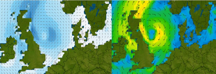 Fig 2. Thursday 18z. Low tracks NW across the North Sea. Left: Hs locally up to 3.0-4.0m. Right: wind peak surrounding the low. This resembles one of the most active scenarios.
On Friday and during the weekend winds weaken as the low fills and eventually dissipates. In its wake high pressure rebuilds over the North Sea, calming things down again. Hs will then lower to below 2.0m as a result.
Conclusion
Despite the blocked nature of the synoptic pattern over the North Sea, stable weather is unlikely to persist as an area of low pressure follows an unusually northwestward pointed path across the area from Wednesday onward. Exact track and development are rather uncertain at the moment of writing though. Expect mist and some fog patches near the low and associated trough, as well as showery outbreaks possibly accompanied by thunder.
Wind and wave-wise your workability might become limited just ahead and along the track of the low. But, after this unstable phase the weather calms down once we get closer to coming weekend with renewed high pressure influences over the North Sea; before a weak Atlantic frontal trough likely comes in from the W later on Sunday.
Always up-to-date
Like this weather briefing? Our monthly newsletter gives you even more insights. Think about the marine weather phenomena, updates about our ever-evolving forecasting products and the latest and most relevant marine weather briefing. Subscribe to receive our Infoplaza marine newsletter once a month.