When carrying out operations at the open air without any barriers, buildings, vegetations or mountains, it is crucial to take into account the wind component. Especially, if the works are very sensitive to wind and when high wind speeds may cause danger for the machinery and most importantly the personnel. This is particularly observed in the open sea, where wind has no obstacles and may be of great danger. Therefore, accurate weather forecasting becomes crucial for offshore operations. Wind forecasts typically come in three main units: meters per second (m/s), Beaufort scale (Bft), and knots (kn, kt).But what is the difference between these three parameters? We will try to figure this out in this article.
What is wind?
The atmosphere, our planet’s outermost layer, is in a constant state of movement, and this movement is what we call wind. In the different areas of the world we can observe high pressure and low pressure areas. The air moves from high pressure area to low. The picture below represents what causes the wind.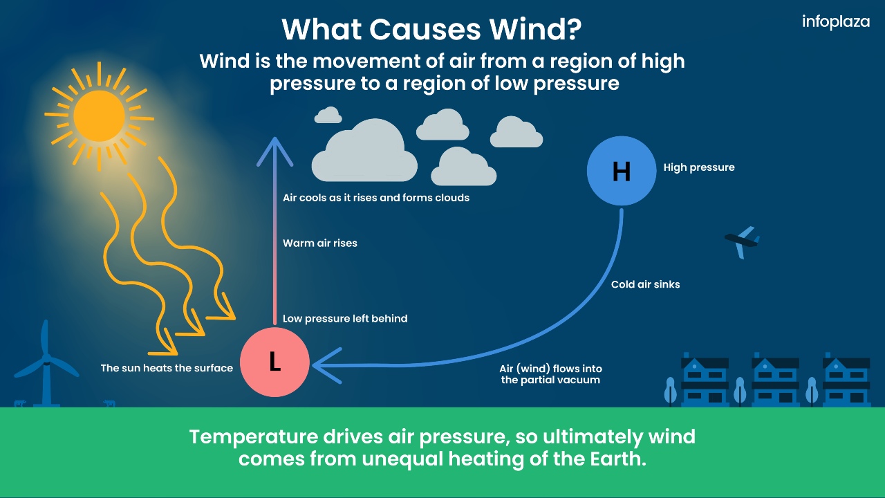 Image: Infoplaza
To illustrate, take, for example, an air balloon and inflate it a little. If you let it go, all air will come out of the balloon. Now take the balloon and inflate it even more. When letting go, the air will come out again but with higher speed. This simple experiment demonstrates a fundamental principle: the larger the pressure difference, the faster the air moves. Scientifically, we express this as follows: the greater the pressure gradient, the higher the wind speed. But how do we measure wind speed? What units do we use?
Wind Measurement Units: Beaufort Scale, Knots, and Meters per Second (m/s)
There are different units of wind measurements. M/s is the only SI-unit for the wind velocity recommended by the World Meteorological Organization and is used almost all over the world. Miles per hour are not as popular but are widely used in the USA and its dependencies. Beaufort is commonly used overall as an addition to the numerical forecast represented in m/s. And at last, knots are widely used in maritime meteorology. The table below outlines these units.
| Force (Bft) | Name | Knots (kt or kn) |
Average wind speed over 10 minutes (m/s) | Wave height (m) | Visual clues |
| 0 | Calm | < 1 | 0 - 0.2 | 0 | Sea is like a mirror. Smoke rises vertically. |
| 1 | Light air | 1- 3 | 0.3 - 1.5 | < 0.15 | Ripples with the appearance of scales are formed, but without foam crests. Smoke drifts from funnel. |
| 2 | Light breeze | 4 - 6 | 1.6 - 3.3 | 0.15 (max 0.3) | Small wavelets, still short but more pronounced, crests have glassy appearance and do not break. Wind felt on face. Smoke rises at about 80 degrees. |
| 3 | Gentle breeze | 7 - 10 | 3.4 - 5.4 | 0.61 (max 0.91) | Large wavelets, crests begin to break. Foam of glassy appearance. Perhaps scattered white horses (white caps). Wind extends light flag and pennants. Smoke rises at about 70 deg. |
| 4 | Moderate breeze | 11 - 16 | 5.5 - 7.9 | 0.91 (max 1.52) | Small waves, becoming longer. Fairly frequent white horses (white caps). Wind raises dust and loose paper on deck. Smoke rises at about 50 deg. No noticeable sound in the rigging. Slack halyards curve and sway. Heavy flag flaps limply. |
| 5 | Fresh breeze | 17 - 21 | 8.0 - 10.7 | 1.83 (max 2.44) | Moderate waves, taking more pronounced long form. Many white horses (white caps) are formed (chance of some spray). Wind felt strongly on face. Smoke rises at about 30 deg. Slack halyards whip while bending continuously to leeward. Taut halyards maintain slightly bent position. Low whistle in the rigging. Heavy flag doesn't extended but flaps over entire length. |
| 6 | Strong breeze | 22 - 27 | 10.8 - 13.8 | 2.74 (max 3.66) | Large waves begin to form. White foam crests are more extensive everywhere (probably some spray). Wind stings face in temperatures below 35 deg F (2C). Slight effort in maintaining balance against wind. Smoke rises at about 15 deg. Both slack and taut halyards whip slightly in bent position. Low moaning, rather than whistle, in the rigging. Heavy flag extends and flaps more vigorously. |
| 7 | High wind, moderate gale, near gale | 28 - 33 | 13.9 - 17.1 | 3.96 (max 5.79) | Sea heaps up and white foam from breaking waves begins to be blown in streaks along the direction of wind. Necessary to lean slightly into the wind to maintain balance. Smoke rises at about 5 to 10 deg. Higher pitched moaning and whistling heard from rigging. Halyards still whip slightly. Heavy flag extends fully and flaps only at the end. Oilskins and loose clothing inflate and pull against the body. |
| 8 | Gale, fresh gale | 34 - 40 | 17.2 - 20.7 | 5.49 (max 7.62) | Moderately high waves of greater length. Edges of crests begin to break into the spindrift. The foam is blown in well-marked streaks along the direction of the wind. Head pushed back by the force of the wind if allowed to relax. Oilskins and loose clothing inflate and pull strongly. Halyards rigidly bent. Loud whistle from rigging. Heavy flag straight out and whipping. |
| 9 | Strong/ severe gale |
41 - 47 | 20.8 - 24.4 | 7.01 (max 9.75) | High waves. Dense streaks of foam along direction of wind. Crests of waves begin to topple, tumble and roll over. Spray may affect visibility. |
| 10 | Storm, whole gale | 48 - 55 | 24.5 - 28.4 | 8.84 (max 12.5) | Very high waves with long overhanging crests. The resulting foam, in great patches is blown in dense streaks along the direction of the wind. On the whole, the sea takes on a whitish appearance. Tumbling of the sea becomes heavy and shock-like. Visibility affected. |
| 11 | Violent storm | 56 - 63 | 28.5 - 32.6 | 11.28 (max 15.85) | Exceptionally high waves (small and medium-sized ships might be for time lost to view behind the waves). The sea is completely covered with long white patches of foam lying along the direction of the wind. Everywhere, the edges of the wave crests are blown into froth. Visibility greatly affected. |
| 12 | Hurricane force | > 64 | > 32.6 | 13.72 | The air is filled with foam and spray. The sea is completely white with driving spray. Visibility is seriously affected. |
The definition of m/s speaks for itself. it represents the distance an air mass travels in one second. Whereas, the Beaufort scale presents qualitative wind description, namely how the wind feels and what impact it could have. The scale was first introduced in the nineteenth century by Francis Beaufort, a hydrographer and Royal Navy officer. In the table above, the last column represents visual clues related to each Beaufort unit. Thus, knowing which clues are related to each Beaufort unit, it is easy to understand what the weather is going to be. Presently, the Beaufort scale is used in many countries of the world to characterize wind over land and sea. Wind in Beaufort units can often be found in weather forecasts.
While m/s and Bft are widely used in weather forecasting for areas above land, windspeeds above sea are mostly represented in knots. A knot equals to one nautical mile per hour, specifically 1.852 km/h (0.514 m/s). It is a non-SI unit of windspeed that is commonly used in maritime meteorology.
Why ‘knots’? The answer is pretty simple. Many years ago the sailors did not have access to the modern technologies such as GPS. To know how fast a vessel was travelling across the sea, a simple tool made of a rope and a piece of wood was created. While the vessel progressed on its voyage, the wooden end of the rope was lowered into the water, remaining in its place as the ship moved forward. As the knots gradually slipped away from the ship and into the sea, their count was counted over 30 seconds using a glass timer. This count of knots served as an estimate of the ship's velocity. So the wind knots refer to actual knots on a rope.
What do meteorologists use, and when?
Meteorologists use different units, depending on the consumer or end user. It’s actually quite easy to understand: weather predictions for areas above land mostly include wind in both m/s and Bft. M/s give a clear numerical estimation, while Beaufort in addition with a corresponding color give a nice visual representation allowing the consumer to have a clear picture of what the weather is going to be like. Meanwhile, maritime meteorologists mainly use knots in their forecasts.