Low pressure persists over the North Sea resulting in quite unsettled conditions over the northern North Sea in the beginning of the week. The weather stabilizes by Thursday providing workable conditions. Meanwhile, the central and southern North Sea remain relatively calm allowing carrying out the operations throughout the whole week.
Synoptic overview
A low-pressure system over the Baltic Sea moves eastward, with an associated frontal trough tracking over the central North Sea on Tuesday. Meanwhile, another low-pressure system southwest of Ireland moves northeastward, crossing the United Kingdom and traversing the central and northern North Sea on Thursday and Friday. Associated frontal troughs influence the entire North Sea area. Simultaneously, a new low forms east of Scotland, tracking eastward and dissipating west of southern Norway by late Friday.
As the weekend approaches, a new broad low-pressure system west of Ireland moves northward, with an associated trough affecting the central and northern North Sea. The low-pressure system reaches the Faroe Islands and then turns toward the Norwegian Sea by Monday. Meanwhile, a ridge of high pressure tracks over the central and southern parts of the North Sea, forming a separate high-pressure system over northern Poland.
Wind and waves
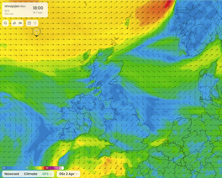
Quite unsettled conditions with strong winds and significant wave heights above 5 meters are forecasted in the northern North Sea on Tuesday and Wednesday (see Figure 1 and Figure 2). As the low-pressure system approaches, the conditions improve, remaining relatively settled during the rest of the week. Meanwhile, the central and southern parts of the North Sea remain relatively calm with winds under 25 knot and significant wave heights below 4 meters. However, as the low-pressure system east of Scotland moves northeastward, unsettled conditions are expected over the southern North Sea on Friday. The sustained wind may exceed 25 knots, and significant wave height may exceed 2.5 meters.
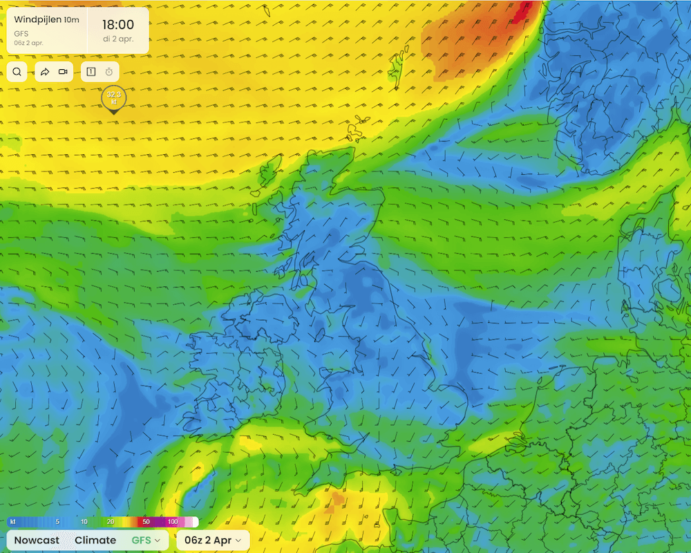 Figure 1: Wind speed in knots according to the American GFS model on Tuesday April 2nd at 18 UTC.
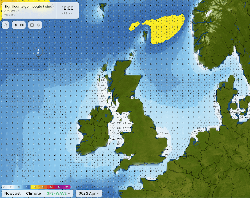 Figure 2: Significant wave height in meters according to the American GFS wave model on Tuesday April 2nd at 18 UTC.
As the low-pressure system west of Ireland moves northward, an increase in wind speed up to 28 knots and significant wave height up to 4.5 meters over the northern North Sea is expected on Sunday. Meanwhile, the wind will increase up to 30 knots and significant wave height up to 2.5 meters over the southern North Sea (see Figure 3 and Figure 4). The low moves further towards the Norwegian Sea, reducing its influence on the southern North Sea on Sunday. Moreover, with the passage of several lows accompanied by frontal troughs, uncertainties across the entire basin of the North Sea arise. Forecasting the exact timing and position of those troughs is quite challenging.
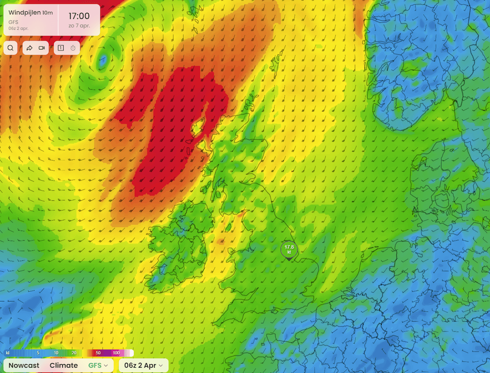 Figure 3. Wind speed in knots according to the American GFS model on Sunday April 7th at 17 UTC.
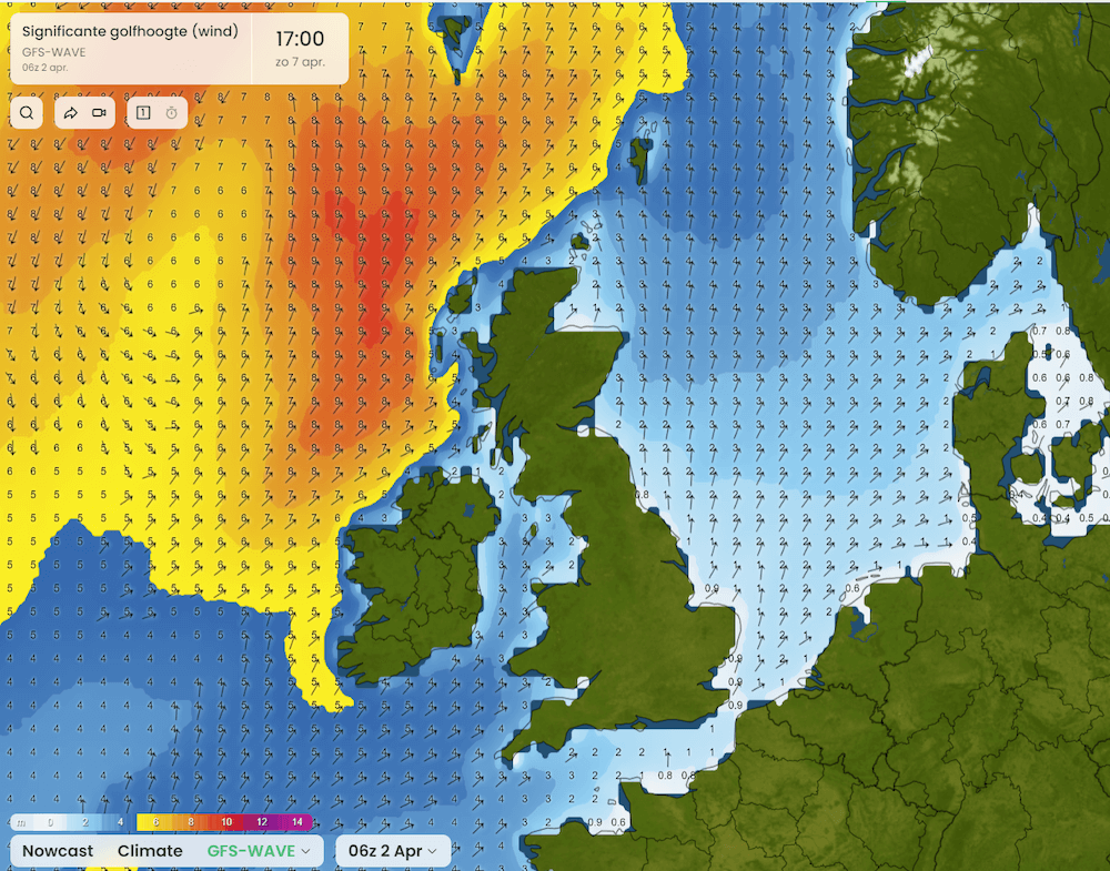 Figure 4: Significant wave height in meters according to the American GFS wave model on Sunday April 7th at 18 UTC.
Conclusion
The conditions remain unsettled in the northern North Sea until Thursday, with winds exceeding 25 knots and significant wave heights surpassing 5 meters today, potentially hindering operations. In particular, the significant wave height is expected to decrease over the next 2 days to values around 3.5 meters. However, as conditions further improve, workability may be restored from Thursday onwards. In contrast, the central and southern parts of the North Sea remain relatively calm, with winds below 25 knots and significant wave heights below 4 meters, allowing operations throughout the entire week.
Always up-to-date
Like this weather briefing? Our monthly newsletter gives you even more insights. Think about the marine weather phenomena, updates about our ever-evolving forecasting products, and the latest and most relevant marine weather briefing. Subscribe to receive our Infoplaza marine newsletter once a month.