This week presents the clearest workable offshore window over the North Sea. At the same time, super typhoon Sinlaku continues to pose a major disruption risk, while an active low-pressure system will make conditions in the eastern Mediterranean less reliable again towards the end of the week. For marine operators, that creates a clear regional split in operational planning. The best opportunities lie over the southern and eastern North Sea, while routing and schedule resilience remain under pressure near super typhoon Sinlaku and across parts of the eastern Mediterranean.
Impact
- North Sea: The southern and eastern sectors offer the most reliable workable window this week, with broader opportunities returning again into Friday and Saturday.
- Super typhoon Sinlaku: Disruption risk remains exceptionally high, with very limited schedule resilience and a continued need for wide safety margins and contingency planning. But there is no risk for the system reaching coastal areas at the moment.
- Eastern Mediterranean: Conditions deteriorate towards the end of the week, narrowing workable windows for crew transfer, towage, dredging support and port logistics.
In short: This week supports offshore execution in the North Sea, but operations near Sinlaku and in the eastern Mediterranean require close attention.
Critical operational window
The most stable conditions are found over the southern and eastern half of the North Sea, where offshore work remains favourable through the week. A disturbance over the northern half from the night to Thursday will temporarily reduce operational windows here, before broader workable windows reopen into Friday and Saturday. In the eastern Mediterranean, operators should expect tighter planning constraints and less operational flexibility.
Weather situation
North Sea
At the start of the week, the pressure gradient over the North Sea remains relatively weak. On Tuesday, winds are mainly southerly to southeasterly at 10 to 20 knots, increasing to around 25 knots at times in northern sectors including Viking, Utsire, Forties and parts of Dogger. Significant wave heights are mostly around 0.5 to 2.0 meters, with the most workable conditions in the southern and eastern sectors.
A more active disturbance crosses the northern half from the night to Thursday, bringing freshening winds and less workable conditions. After that, the pressure gradient eases again, allowing broader workable windows to develop into Friday and Saturday. Over the southern and eastern half, conditions remain favourable for offshore work throughout the week.
Area around super typhoon Sinlaku
There is no operational improvement in sight around super typhoon Sinlaku. Sustained winds remain around 105 to 135 knots, with stronger gusts near the core. Significant wave heights build to around 12 to 13 metres close to the centre, while a much broader surrounding area continues to deal with severe sea state and heavy swell.
For ship routing, disruption risk stays exceptionally high through the second half of the week. Schedule resilience remains limited, and any planning near the system should allow for wide safety margins and strong contingency cover. The system is expected to track slowly north towards Japan during the weekend while gradually weakening.
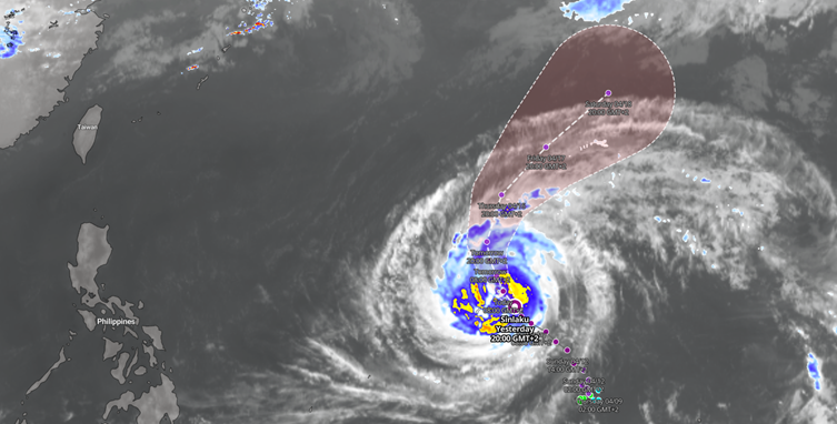
Figure 1: Forecasted track of super typhoon SINLAKU
Eastern Mediterranean
In the eastern Mediterranean, a low-pressure system increasingly affects the basin towards the end of the week. Across the southeastern Aegean, south of Crete and eastwards towards the Levant, northeasterly to east-northeasterly winds are expected to increase to 25 to 35 knots. The strongest conditions are likely in offshore areas and near mountain ranges where wind funnelling can occur.
Significant wave heights build from around 1.5 to 2.5 meters to locally 3.0 to 4.0 meters during the passage of frontal troughs. That will narrow workable windows for crew transfer, towage, dredging support and port logistics, especially in areas with limited shelter.
Conclusion
The operational contrast this week is clear. The North Sea offers the best offshore window, especially across the southern and eastern sectors, while Sinlaku continues to drive severe disruption risk and the eastern Mediterranean becomes more restrictive again later in the week. Existing customers can use the Infoplaza dashboard and monitoring services to track the most workable windows and manage operational timing. New to Infoplaza? Get in touch to explore how our decision-support solutions can help improve offshore planning and reduce weather-related uncertainty.