Low pressure will dominate mostly during this week. Most of the time low-pressure conditions mean marginal or no workability options. However, this time there might be a slightly different situation.
You will find the video briefing at the end of the article
Synoptic overview
A complex low-pressure structure lingers NW of Ireland on Tuesday. An associated frontal trough stretches N of Scotland, over the North Sea, towards the far S of Norway. Another frontal trough tracks over the North Sea on Wednesday, followed by a ridge of high pressure on Thursday. A new frontal trough tracks over the North Sea in the night to Friday. The associated low-pressure core is still located NW of Ireland but the pressure inside the low-pressure core is rising, resulting in fronts getting weaker over time. The low-pressure core tracks E over the northern half of the North Sea during the weekend, while high pressure builds over the Atlantic Ocean. In between those two-pressure systems, a northwesterly flow picks up over the North Sea, mainly on Sunday.
Wind and waves
Despite the various frontal troughs that are expected to affect the North Sea this week, there might well be workability opportunities offshore. The main reason for this is that the pressure gradient is in general quite weak, resulting in less wind and therefore fewer high waves.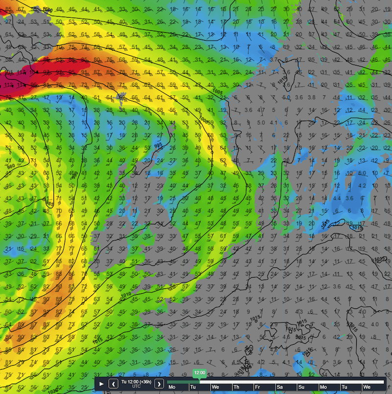 Figure 1: Isobars (black lines) and wind direction and wind gusts speed in km/h at Tuesday 12UTC.
Despite the frontal trough located over the North Sea, wind speeds are not that strong (Please see Figure 1). Furthermore, the combination of relatively warm upper air and the lack of strong winds, prevent the formation of high waves (Please See Figure 2). Despite the unsettled conditions waves will not exceed 1,5 -2,0 meters in most locations over the North Sea on Tuesday. Especially near the Dutch, Danish and E UK coast, Hs will barely reach 1 meter, potential resulting in good workability for most operations.
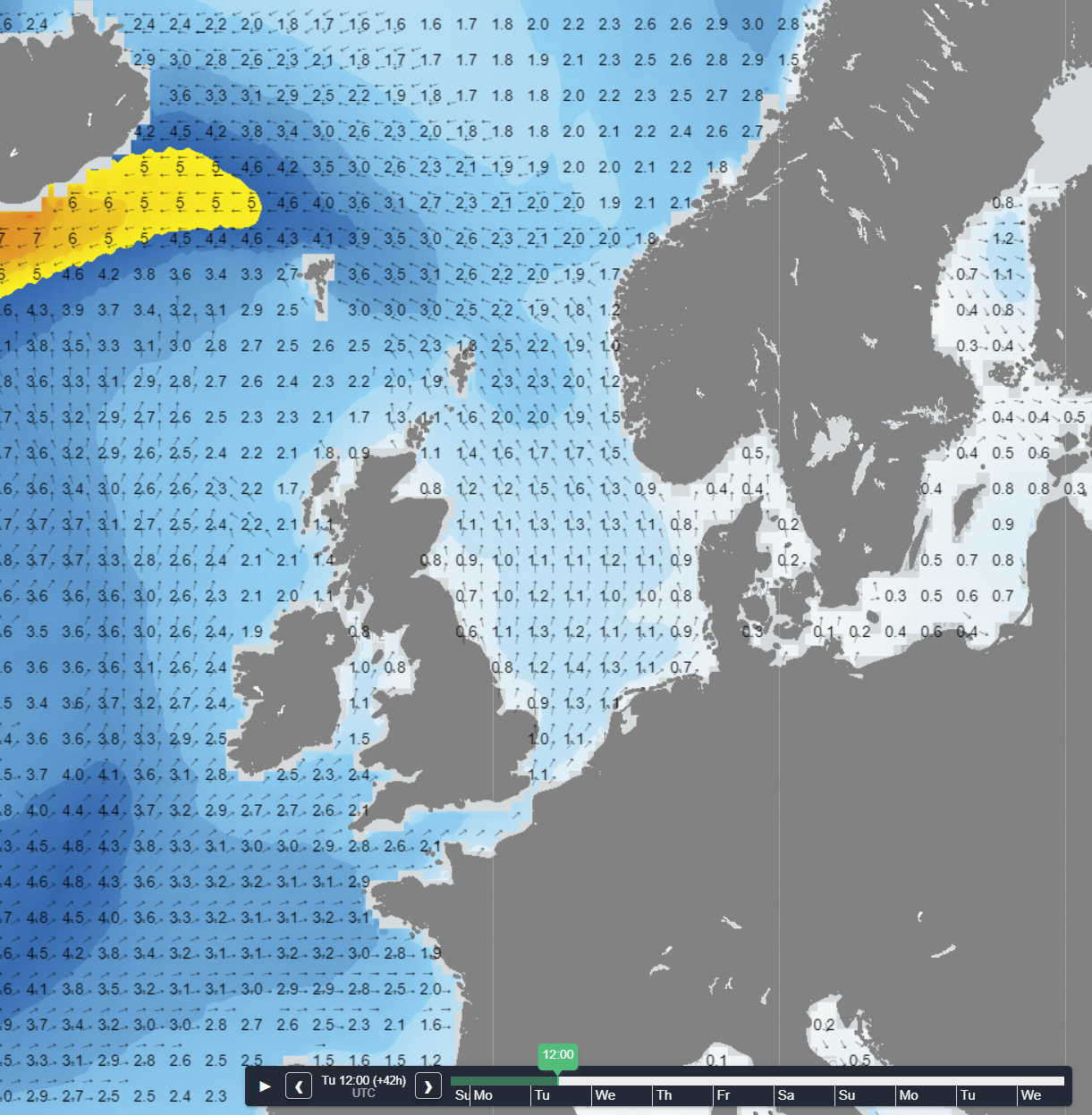 Figure 2: Significant wave height and direction on Tuesday at 12UTC.
Another trough will pass over the North Sea on Wednesday, already visible on Figure 1 just W of Ireland. Wind speeds will be higher on this front compared to the one on Tuesday (Please see Figure 3). Furthermore, the air behind the frontal trough is relatively cold and unstable, resulting in higher waves (Please see Figure 4). So, Hs is will probably reach 2,5-3,5 meter, locally a bit more, over a large part of the North Sea. Due to the south westerly flow, the UK provides a relatively sheltered location for the operations just out on the E coast of the UK.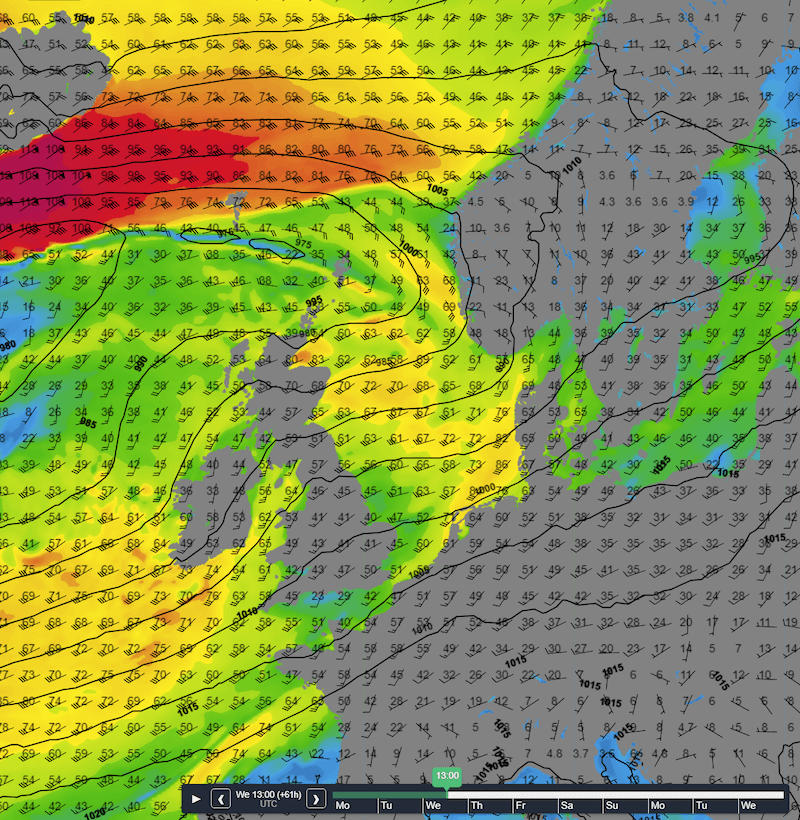 Figure 3: Isobars (black lines) and wind direction and wind gusts speed in km/h on Wednesday 13UTC.
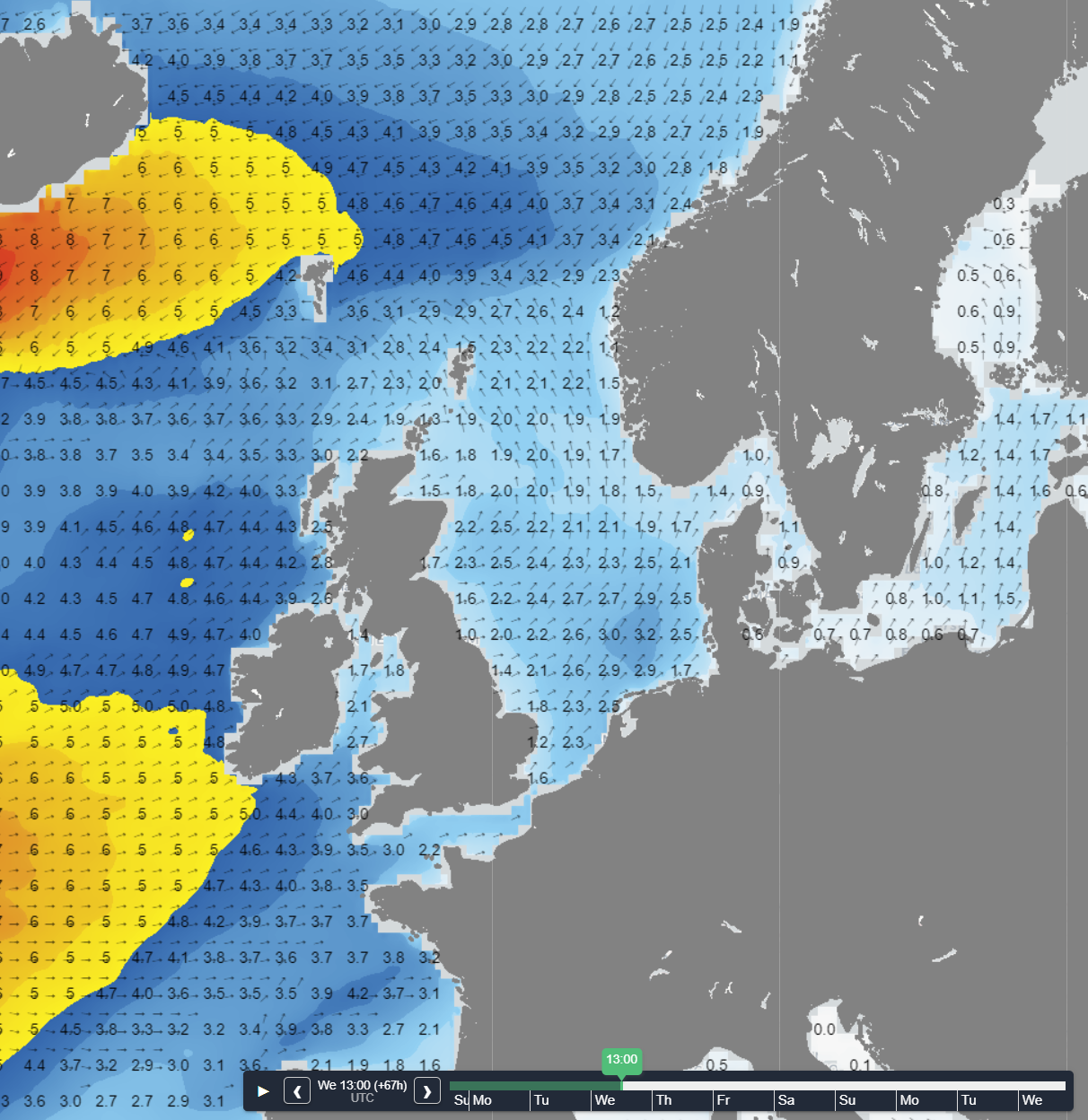 Figure 4: Significant wave height and direction on Wednesday at 13 UTC
Wind and waves will be calm again on Thursday as the ridge tracks E over the North Sea. Especially on Thursday and possibly Friday as well, there might be some workability windows again, despite the frontal troughs close by.
The filling Atlantic low pressure area tracks E over the North Sea during the weekend and the wind will veer to a northwesterly direction.
Conclusion
Various frontal troughs will sweep across the North Sea this week. The parenting low pressure area is located NW of Ireland and tracks slowly E, crossing the North Sea during the weekend. The most active trough passes on Wednesday, resulting in strong winds and high waves. During the rest of the week, the weather remains unsettled but both wind and waves remain relatively calm. As a result, some workability opportunities will be available , especially close to shore. Follow us on LinkedIn for more insights
Every week we will post an updated weather briefing on the Infoplaza website and the Infoplaza Marine Weather Operations LinkedIn page. We will also share weather related articles and topics on offshore weather on these pages. We hope all our clients stay safe at sea this week. Please feel free to contact us at any time if you have any questions or remarks.


