Last week, high pressure dominated the weather over the North Sea for the majority of the week, interrupted by a secondary low that crossed the North Sea. During the weekend, high pressure regained its influence over the North Sea, extending a ridge over the area. The ridge was pushed away towards the east by a low-pressure area lingering near Greenland. This low pressure spawns multiple separate lows and frontal troughs, that cross the North Sea this week. Unsettled conditions will prevail as a result. In between these systems weather conditions may improve, meaning that there will be some workable weather windows at times this week.
Synoptic overview
A complex Atlantic low is located in between Greenland and Iceland on Tuesday. An associated frontal trough leaves the North Sea, moving further east over the Baltic Sea. In its wake, a mobile ridge of high pressure crosses the North Sea area on Tuesday from west to east. New low pressure forms west of Ireland in the meantime, arriving over the UK on Tuesday night into Wednesday. An associated frontal trough crosses the North Sea early on Wednesday. The parental low will linger over the Northern North Sea until Friday, moving away to the north at that stage. Strong high pressure over Russia, extends a weak ridge towards the North Sea on Friday. The ridge retreats quickly towards the east again, as a new low-pressure area approaches from the west. The system tracks over the southern parts of the North Sea later on Friday and Saturday. Afterwards, a high-pressure area will move from the Azores to France. This high connects to the high-pressure area over Northern Russia. As a result, strong high pressure develops with the center over Northwest Russia, extending a ridge over the North Sea.You will find a video briefing at the end of this article
Wind and waves
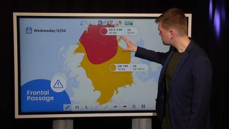
A frontal trough leaves the North Sea area at the beginning of Tuesday. We see a strong breeze and waves of 2 – 2.5 meters over Skagerrak and Kattegat. Also, over the Southern North Sea, strong breeze will also occur. The wind creates a wave field with significant wave heights up to 2.5 meters. The wind and the wave field propagate towards the east during the day, towards the German Bight and Denmark, while gradually dissipating. In the rest of the North Sea, waves will be generally between 1 and 2 meters. Because the wind is of westerly direction, the sheltering effect of the British Isles comes into play (short fetch). Waves along the British coastline will generally not exceed 1 meter. Another thing that is good to note, is that several thundery showers are possible across the North Sea during the course of the day.On Wednesday, a frontal structure will cross the North Sea from west to east. Winds will pick up significantly, with near-gale force winds over a large part of the area. Winds pick up even more during the frontal passage (please see Figure 1). With more than 35 knot winds, gale force winds occur shortly (with wind gusts up to 55 knots). Waves are expected to increase up to 3.5 meters over the Central North Sea and northern part of the Southern North Sea (whereas the Southern North Sea will experience 1.5 – 2.5 meter waves). Over the Northern North Sea, waves will increase even further, up to 5.5 meters (please see Figure 2).
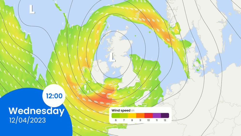 Figure 1: Isobars (black lines) and wind direction and wind speed in kts (barbs) and Bft (coloring) on Wednesday at 12 UTC.
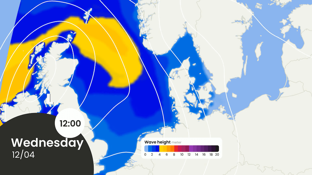 Figure 2: Isobars (white lines) and significant wave height on Wednesday at 12 UTC.
During Thursday night and into Thursday itself, an extensive wind field forms surrounding area of the low-pressure area, which is located over the Central North Sea. Especially over the Southern North Sea, winds may pick up to 30 kts and the significant wave height will increase as a result to 2.5 – 3.5 meters (please see Figure 3). The wind and wave field will then move to the German Bight and Denmark during the day, as the low-pressure system slowly tracks north. Again, some lightning activity could be observed over the Southern North Sea. The Northern North Sea experiences a calmer day, with Hs-values of maximum 2.0 meters.
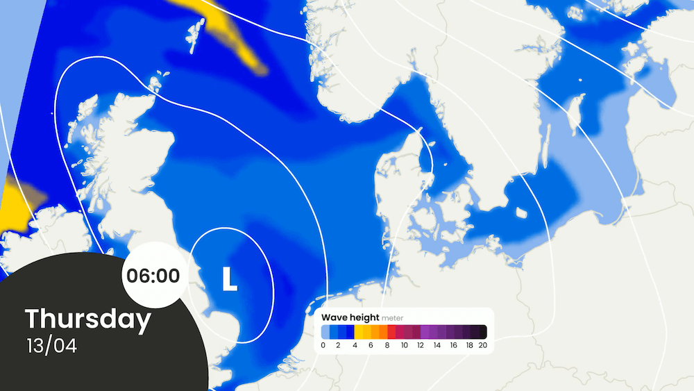 Figure 3: Isobars (white lines) and significant wave height on Thursday at 06 UTC.
On Friday, we expect to see calmer weather and wave conditions across the North Sea area. The interlude however, is brief since a new low-pressure area crosses the North Sea in the course of that day and on Saturday. Wind and waves pick up shortly, before decreasing again due to the increasing influence of a high-pressure area (please see Figure 4).
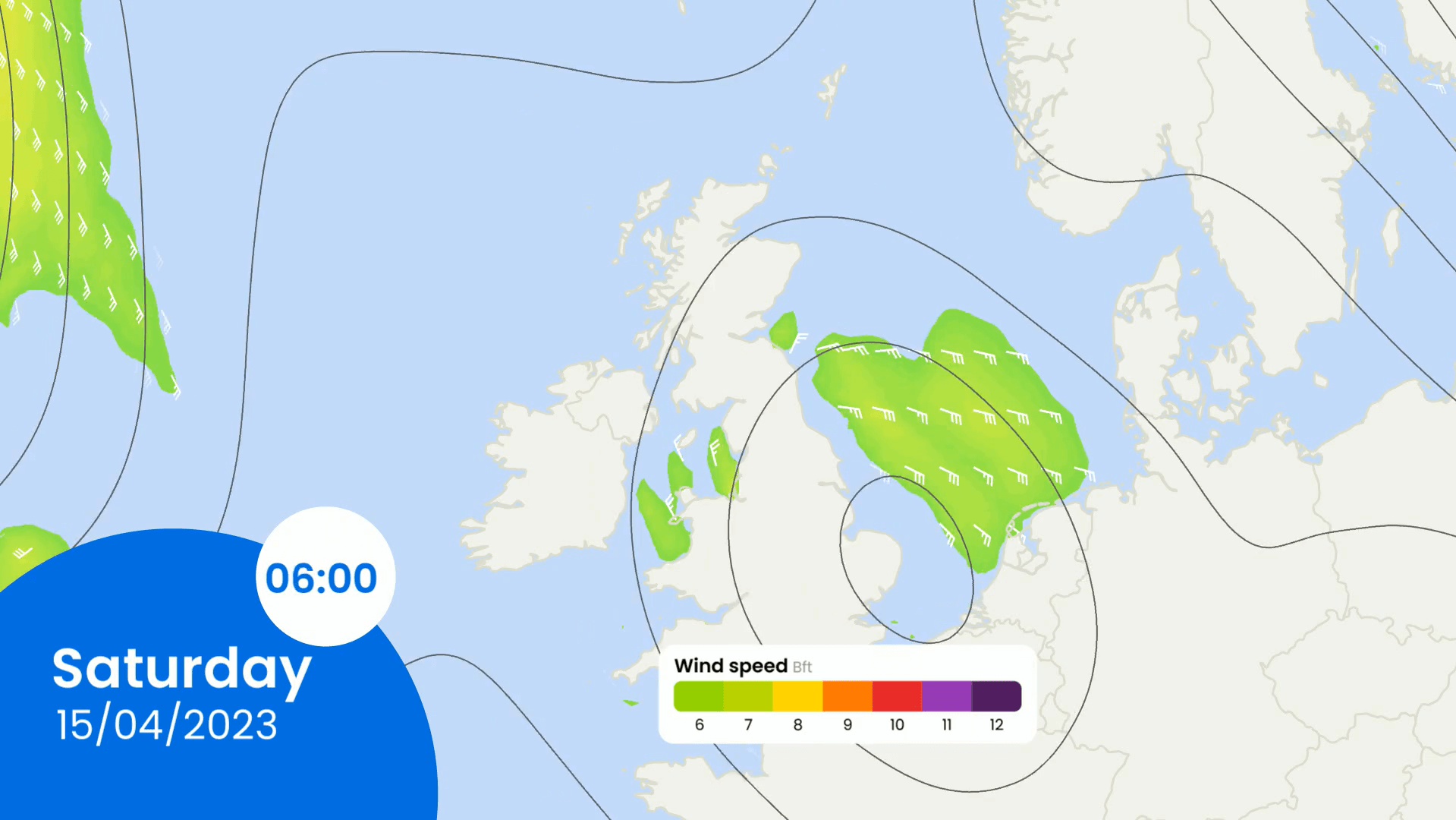 Figure 4: Isobars (black lines) and wind direction and wind speed in kts (barbs) and Bft (coloring) on Saturday at 06 UTC.
Conclusion
This week’s weather is dominated by an Atlantic low-pressure system. Multiple low-pressure areas cross the North Sea this week, together with several frontal troughs. Wind and wave peaks occur at times and in between wind and waves will decrease into more workable conditions. Some thundery showers are also possible to occur this week. To conclude, unsettled conditions prevail this week. In between these systems weather conditions can improve, meaning that there will be workable weather windows as well at times this week. In the course of the weekend, conditions will improve as high pressure gains influence over the North Sea area.
Weekly weather briefing
Every week we will post an updated weather briefing on the Infoplaza website and the Infoplaza Marine Weather Operations LinkedIn page. We will also share weather related articles and topics on offshore weather on these pages. We hope all our clients stay safe at sea this week. Please feel free to contact us at any time if you have any questions or remarks.