Incoming high pressure from the west produces calm weather and good workability opportunities over the larger part of the North Sea during the second half of the week. Ahead though, quite gnarly northwesterlies emerge over the northeastern half of the North Sea as an area of low pressure loiters over southern Scandinavia at first.
Over the last few weeks weather charts over the North Sea have been mostly dominated by blocked patterns, with unseasonably frequent northerly airflows occurring over the area. This week though, it seems likely we are in for a prolonged period of calmer conditions dominated by high pressure coming in from the Atlantic. There is still some uncertainty concerning the eventual location of the high and its ability to fully exclude the influence of low pressure remaining over Scandinavia initially. Find out the details in this week’s weather briefing below.
You will find a video briefing at the end of the article.
Synoptic overview
An area of high pressure (1030 hPa) lingers just southwest of Ireland on Tuesday while pressure is low over Scandinavia. A few (minor) associated secondary troughs swiftly move southeastwards across the northeastern North Sea over the course of the day, occasionally tightening the pressure gradient in that area. On Wednesday this high slowly builds a ridge into the northern North Sea, expected to gradually shift south afterwards before grinding to a halt over the southern North Sea on Thursday.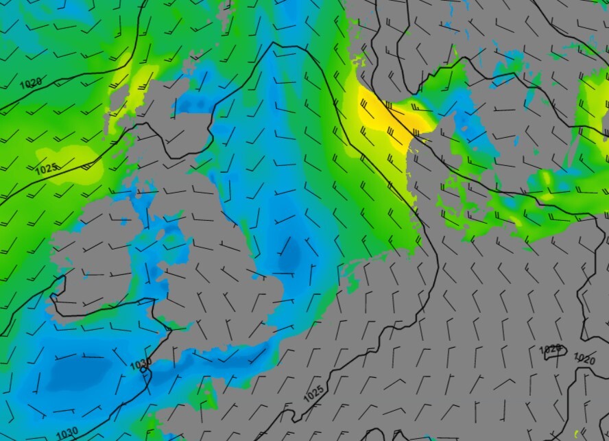
Fig. 1. Ridge of high pressure coming in from the west. Wind field over the northeastern North Sea slowly retreats east.
It is uncertain where the exact location of this ridge will eventually settle. Most models suggest it may settle over the southern parts of the North Sea, with decaying Atlantic fronts still influencing the northern half of North Sea. As the situation is largely high pressure dominated, strong winds and high waves seem unlikely to occur with these weaker conditions. Obviously, the eventual location of the ridge will be the main factor in how things pan out.
Towards the end of the week and into the coming weekend we still see the predominance of high pressure over the North Sea, perhaps even strengthening and moving N in the course of the weekend. With this scenario Atlantic influences are kept at bay and general calm conditions continue to prevail. As the air gets increasingly warmer by then the risk of mist and fog patches increases as the underlying SST’s are still rather low.
Wind and waves
As a result of the described synoptic constellation, a fresh to strong northwesterly airflow (5-6 Bft) unfolds over the North Sea on Tuesday. Significant wave height associated with this wind field will range from around 1.0m just east of the UK (partly sheltered) to 2.0-3.0m further east. Strongest winds will be located over northeastern Forties, Fisher and the German Bight. In these areas the influence of high pressure is limited, and the relative closeness of the Scandinavian low can be felt.
Due to funneling effects along the Norwegian coast a rather tight pressure gradient unfolds and winds might peak at near gale force (7 Bft), or even gale force (8 Bft), over Utsire, Fisher and parts of Skagerrak later on Tuesday and Wednesday night. Hs might peak at 4.0 or even 5.0m, possibly lasting well into Wednesday.
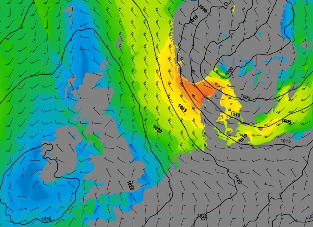
Fig. 2 above and Fig. 3 below. Strong winds and rather high waves ahead of the ridge over the northeastern North Sea on later on Tuesday/Wednesday.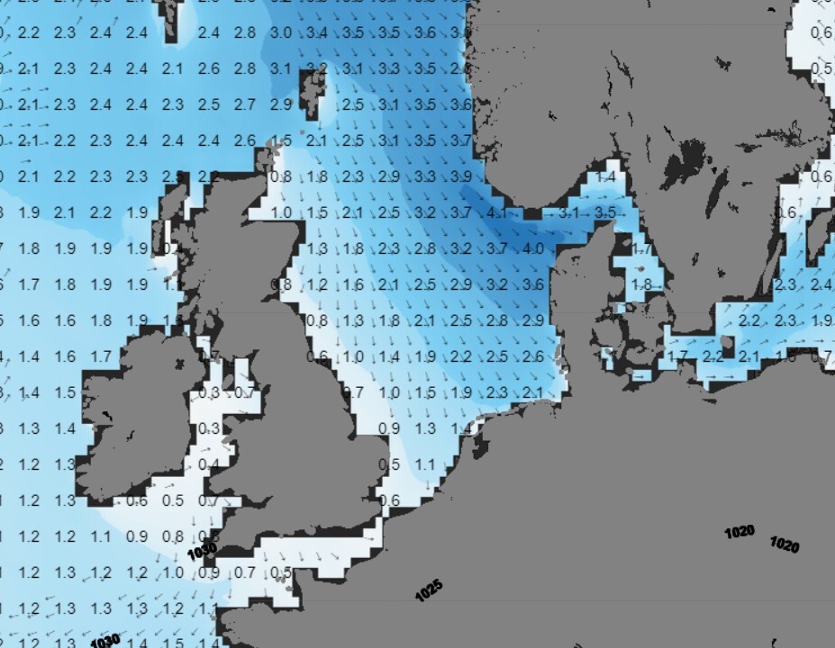
During the course of Wednesday the previously discussed ridge comes in from the west, gradually loosening the pressure gradient over the North Sea. Winds will respond accordingly and decrease to a gentle or moderate breeze (3-4 Bft) coming from the southwest. From Thursday onward this rather calm setup continues well into the coming weekend as the ridge most likely settles over the southern North Sea. Hs is expected to gradually lower to below 2.0m.
Conclusion
As discussed, this week can be dissected into two phases. One of which is being dominated by northwesterly winds ahead of the incoming ridge, lasting well into Wednesday. The other contains rather calm conditions under the influence of this ridge which settles over the southern North Sea from Thursday onward. This period especially has great workability potential for most of our offshore clients. Please be aware that fog patches may affect operations.
Weekly weather briefing
Every week we will post an updated weather briefing on the Infoplaza website and the Infoplaza Marine Weather Operations LinkedIn page. We will also share weather related articles and topics on offshore weather on these pages. We hope all our clients stay safe at sea this week. Please feel free to contact us at any time if you have any questions or remarks.