The week commences with two deep low-pressure areas crossing the North Sea from west to east. One of them is already moving into southern Scandinavia, while the next one is forecasted to cross the southern North Sea tomorrow. Consequently, we can expect occasional wind and wave peaks, followed by relatively short-lasting periods of workable conditions. Towards the end of the week, low pressure will settle over Scandinavia, maintaining a steady northwesterly flow over the North Sea.
Synoptic overview
A low-pressure area (991 hPa) will move east into southern Scandinavia and progress northward across Sweden tomorrow. Tonight, a weak mobile ridge of high pressure will pass ENE across the North Sea, bringing temporary calmer conditions. Subsequently, the next low-pressure system (982 hPa) will arrive over Ireland tonight, moving east across the UK tomorrow morning and further east across the North Sea in the afternoon and evening. This will lead to the influence of associated frontal troughs over the central and southern North Sea.Towards Thursday and Friday, low pressure will be established over Scandinavia, while high pressure near the Azores forms a ridge towards the UK. As a result, a steady northwesterly flow will prevail over the North Sea on these two days. For the weekend, there is some uncertainty, with low pressure remaining close to the North Sea. The exact track of the low pressure on Saturday and Sunday is still uncertain, as it may either move into the central/southern North Sea or eastward into France.
Wind and waves
This afternoon and evening, the highest wind speeds will occur on the southwestern flank of the first mentioned low-pressure area. Wind speeds of 20-25 kts are expected just north of the Netherlands and over the German Bight, with associated significant wave heights of up to 2.0 meters. By midnight, winds are forecasted to drop to around 10-15 kts, resulting in much of the North Sea experiencing wind speeds of around 10 kts or even less, thanks to the mobile ridge crossing the area. Significant wave heights will mostly reach between 0.5 and 1.0 meter. Early Wednesday, the incoming low pressure will increase wind speeds to 15-25 kts over the central and southern North Sea. Over the shipping sectors Thames and Humber, winds may reach around 30 kts, with waves up to 2.5-3.0 meters around the core of the low-pressure system. The northern North Sea will remain relatively calm during this entire period, with winds and waves mostly fluctuating around 10 kts and 1.0 meter, respectively.On Thursday morning, as low pressure moves east into Denmark, wind and waves will gradually come down over the southern North Sea. Simultaneously, a high-pressure ridge will extend over the UK from the southwest, leading to a tightening pressure pattern over the North Sea from the north. This will result in a steady northwesterly wind covering the entire North Sea with wind speeds between 15-23 kts. Along the Norwegian southwest coast, winds may reach up to 30 kts. Significant wave height is expected to be around 1.5-2.5 meters on Thursday and Friday, with slightly higher waves just south of Norway at just over 3.0 meters. It is still too early to determine what will happen during the weekend. However, if low pressure reaches the southern North Sea, winds may pick up to 20-30 kts again, with significant waves reaching up to 2.5 meters.
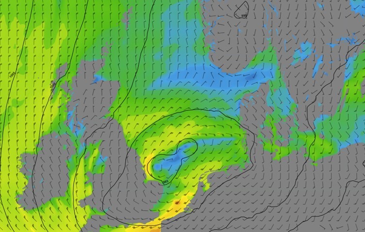 Figure 1: Isobars (black lines 5hPa) and wind speed/direction (kts) valid Wednesday, August 2nd, 18 UTC. Low pressure crosses the North Sea from west to east.
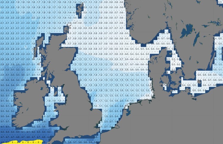 Figure 2: Significant wave height/direction (m) valid Wednesday, August 2nd, 18 UTC. Wave height increases around the low pressure core between the UK and Benelux.
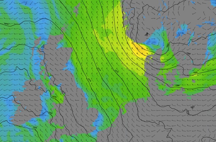 Figure 3: Isobars (black lines 5hPa) and wind speed/direction (kts) valid Friday, August 4th, 12 UTC. A steady northwesterly flow over the North Sea as low pressure settles over Scandinavia and a ridge extends into the UK.
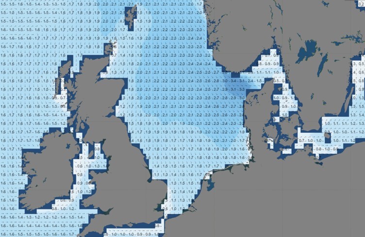 Figure 4: Significant wave height/direction (m) valid Friday, August 4th, 12 UTC.
Conclusion
This week's weather will start unsettled due to two low-pressure areas crossing the North Sea, resulting in relatively short-lasting weather windows over the central and southern North Sea. The northern North Sea will remain unaffected by low-pressure systems, providing overall good working conditions. There may be occasional rain showers over the southern North Sea, sometimes accompanied by local thunder. Visibility should generally not be a problem this week, except for some reduced visibility during rain showers.Towards the end of the week, weather conditions are expected to gradually improve, but it remains uncertain if these improvements will extend into the weekend. Infoplaza will continue to monitor the latest weather developments, so please make sure to check our daily updated forecast reports to stay informed about the latest developments.
Learn more about the weather
We just launched our new resources page. Here you will find special content like videos, webinars and whitepapers that will guide you to a decision point. Use these expert insights to improve your business or simply to get your knowledge about marine weather up-to-date.