High pressure dominates the weather over the larger part of the North Sea this week, especially in the south. Low-pressure areas move eastwards via the Norwegian Sea and the associated frontal troughs cause the winds and waves to increase at times over the central and northern North Sea.
Synoptic situation
High pressure over Poland extends a ridge westward over the southern North Sea into England. The ridge of high pressure is expected to shift southeast later on Wednesday, as a frontal trough approaches from the west. This frontal trough causes winds and waves to increase over the whole North Sea later on Wednesday and on Thursday.
New high pressure builds over the English Channel on Friday. This high shifts slowly east and winds will decrease. Meanwhile, a new frontal trough will move east just north of Viking and winds will increase again, this time from a more westerly direction. A new ridge of high pressure is expected to move east via the North Sea during the weekend.
Wind and waves
Most of the wind this week is expected ahead of the first frontal trough, on Wednesday evening. Gale force winds from the SSW are expected over the central and northern North Sea and severe gale is possible in or around Viking.
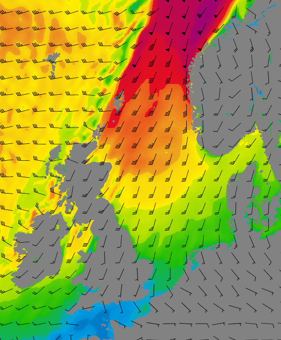 Figure: Wind barbs and wind speed on Wednesday 18 UTC, GFS.
Waves are expected to increase to 7.0-8.0 meters in the most northern part of the North Sea. In Forties, waves will be lower but still in the region of 4.0 and 6.0 meter. Later this week, wind and waves might increase again at times, but not that much as late Wednesday. In the southern North Sea, waves in general are expected to remain below 2.0 meters.
Have a look at our video briefing by marine meteorologist Arjan Willemse:
Conclusion
High pressure causes the wind and waves to remain relatively calm over the southern North Sea. Over the central and northern North Sea, frontal troughs may result in more unsettled conditions at times. This is most pronounced late Wednesday, when severe gale is expected over the east Shetland Basin.Weekly weather briefing
Every week we will post an updated weather briefing on the Infoplaza website and the Infoplaza Marine Weather Operations LinkedIn page. Feel always free to contact us for weather related topics in case there is any need.