The week has started with calm conditions. However, the ridge of high pressure delivering the calm conditions will shift away east, and frontal troughs and a low-pressure area get a grip on the North Sea weather later this week. Most activity is expected on Friday.
Synoptic situation
High pressure resulted in calm conditions over the North Sea over the last days. The center of high pressure is positioned over central Europe, and the associated ridge is expected to shift slowly east via the Baltic on Tuesday and Wednesday. Meanwhile, frontal troughs will then start to gain ground from the west. The first frontal trough will cross the North Sea on late Wednesday, followed by a second one on Thursday. More activity is expected on Friday as a separate low is forecasted to cross over the North Sea as well. However, the exact track is uncertain as the American models expect it to track east via the central North Sea, while the European models calculate a more northerly course, via Forties and Viking. Both models agree in a mobile ridge of high pressure on Saturday, followed by more low-pressure activity afterwards.
Wind and waves
Conditions will be calm over the North Sea until Wednesday evening. Then, the first frontal trough forecasted will cause winds to increase to 7 Bft in the northern North Sea. Most of the winds are expected on Friday, on the west and south side of the approaching low-pressure area. Northwesterly winds might reach strong gale force. This may happen around the Humber area according to the American model (see figure 1), but more northerly according to the European model (see figure 2). Clearly, the confidence of the forecast is low by the end of the week, due to uncertainty about the exact track of the low-pressure area.
Significant waves are between 2.0 and 3.0 meters in the northern North Sea and around 1.0 meter in the southern North Sea at first. Waves will grow later this week, in combination with the increasing winds. Maximum waves are expected on Friday, and 4.0-5.0 meter is well possible over the bigger part of the North Sea, dependent of the exact track of the low-pressure area.
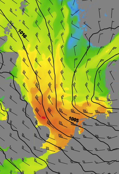
Figure 1: Wind speed on Friday 12 UTC, according to the American model GFS.
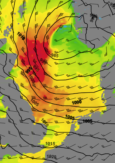
Figure 2: Wind speed on Friday 12 UTC, according to the European model ECMWF.
Conclusion
The week has started calmly. Wind and waves are expected to increase gently from late Wednesday. Most activity this week is expected on Friday as a low-pressure area will cross the North Sea. Northwesterly winds behind this low-pressure area are expected to reach strong to gale force.
We hope all our clients stay safe at sea this week. Please feel free to contact us at any time if you have any questions or remarks.
Weekly weather briefing
Every week we will post an updated weather briefing on the Infoplaza website and the Infoplaza Marine Weather Operations LinkedIn page. We will also share weather related articles and topics on offshore weather on these pages.