In the coming days, the weather over the North Sea will be quite calm. High pressure dominates and a weak southerly flow brings relatively mild air. From the upcoming weekend onwards, the weather pattern will clearly change. An active low-pressure system will bring strong winds and high waves.
Synoptic overview
A weak low-pressure system is located near Iceland. Its associated trough will fill in over the eastern half of the North Sea today (Tuesday). Another minor low pressure area tracks east over the North Sea on Wednesday. Following this, a strong ridge builds up from the Azores high towards the North Sea. This ridge will dominate the weather on Thursday.On Friday, an active low-pressure system forms west of Iceland. This low gradually moves towards southwest Norway on Saturday and reaches Denmark on Sunday. The cold front passes through during the night to Saturday. Behind this front, the wind gradually shifts from the west to the northwest. Due to the combination of a strong northwesterly wind (long fetch) and cold upper air behind the cold front, waves will be particularly high, especially on Saturday and Sunday.
Wind and waves
On both Tuesday, Wednesday, and Thursday, the weather is calm over large parts of the North Sea. The small low-pressure system moving eastward over the central North Sea on Wednesday hardly causes an increase in wind or waves. Wind speeds over large parts of the North Sea will not exceed 20 knots until Thursday evening. Significant wave height only exceeds 2 meters in the far north of the North Sea. Over other parts of the North Sea, significant wave height often ranges between 1 and 2 meters until Thursday evening. Due to light winds and relatively warm upper air, the likelihood of mist/fog is quite high during these days.
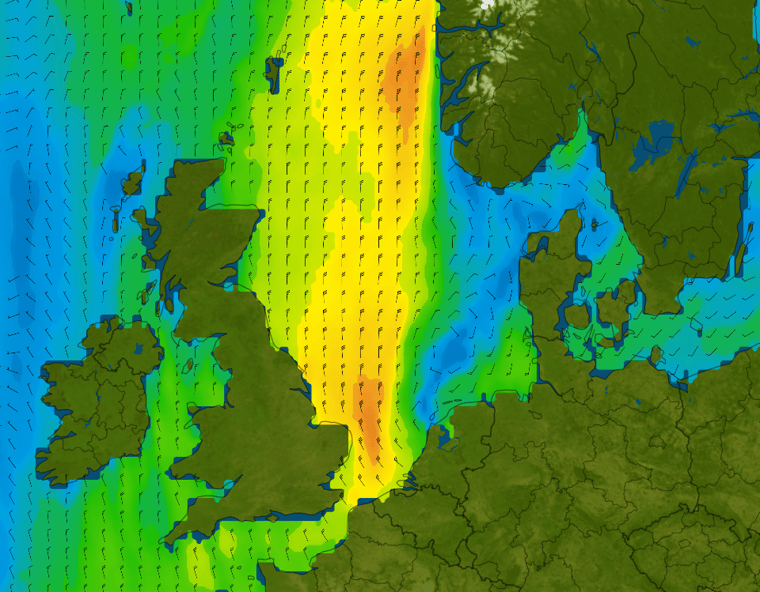
From Friday onwards, the weather pattern over the North Sea will change. An active low-pressure system will bring unsettled weather again, with occasional strong winds and sometimes high waves. The most active weather is expected later in the weekend as the low-pressure system moves towards Denmark (Figure 1). Behind the low, a strong to gale-force northwesterly to northerly wind will blow, reaching force 7 to 8. The combination of strong winds and a long fetch will also result in high waves. Significant wave height over large parts of the North Sea will range between 4 and 6 meters (Figure 2). Figure 1: Wind speed and wind direction according to GFS on Sunday 24th of March at 10UTC.
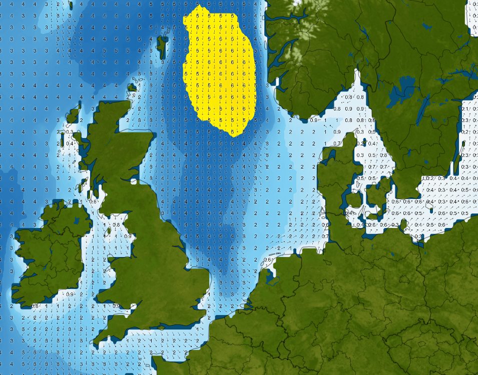 Figure 2: Significant wave height and wave direction according to GFS on Sunday the 24th of March at 10UTC.
Conclusion
Until Thursday evening, the weather is predominantly calm. There isn't much wind (<20 kts) in general and the significant wave height often ranges between 1 and 2 meters. This is excellent weather for many offshore operations. However, visibility can sometimes be an issue. Due to the calm conditions, mist and fog easily form over the North Sea. From Friday onwards, there's a big weather shift. An active low-pressure system will bring unsettled weather with occasional strong winds (force 7-8) and significant wave heights ranging from 4 to a maximum of 6 meters.Always up-to-date
Like this weather briefing? Our monthly newsletter gives you even more insights. Think about the marine weather phenomena, updates about our ever evolving forecasting products, and the latest and most relevant marine weather briefing. Subscribe to receive our Infoplaza marine newsletter once a month.


