After the calm conditions experienced over the North Sea last week, the atmosphere is gradually becoming more dynamic. Multiple low-pressure systems are approaching the UK and the North Sea, leading to increasing winds and waves. This is particularly noticeable in the northern North Sea. However, it's not entirely negative news, as the low-pressure activity is alternated by periods of influence from high pressure.
Synoptic overview
The high pressure system that brought calmer conditions over the North Sea last week, which was centered over Scandinavia, is gradually shifting eastward. Today, its influence is primarily confined to the Baltic Sea, while the North Sea will increasingly come under the influence of low-pressure systems originating from the Atlantic.
This afternoon, a low-pressure system is expected to develop northwest of Ireland. It is forecasted to track northeastward, passing over the Faroe Islands by tomorrow and reaching Norway by early Thursday. The associated frontal trough will primarily impact the northern North Sea on Wednesday, with lesser effects expected in the central North Sea. Meanwhile, high pressure is set to strengthen over central Europe during this period.
By Thursday, conditions are expected to ease somewhat as a weak ridge, associated with the high pressure system over central Europe, moves over the North Sea. However, this ridge will shift eastward later in the day as a new low-pressure system approaches Ireland. Low pressure is forecasted to move northeastward across the northern UK early on Friday, continuing its track across the northern North Sea throughout the day before reaching southern Norway by Saturday night.
On Saturday, another high-pressure ridge is expected to cross the North Sea, resulting in a return to calmer conditions. However, this interval will be brief, as the next low-pressure system is already approaching the UK by that time.
Wind and waves
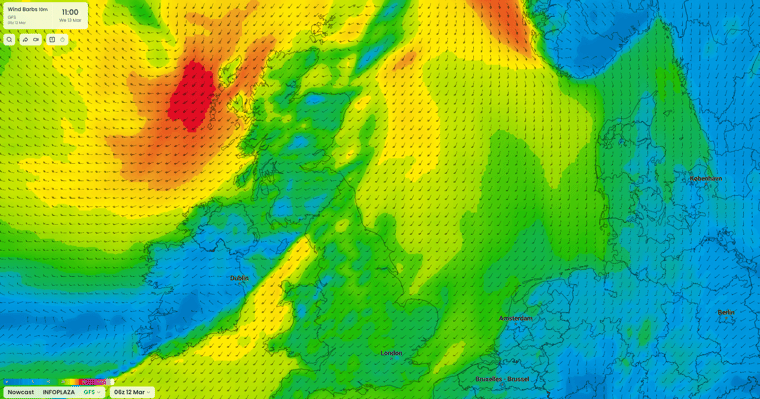
As low pressure gradually moves northeast past the UK later today, wind and waves start to pick up over the North Sea. As it passes the Faroe Islands, winds will reach well into gale force over the northern North Sea. The American GFS model forecasts even strong gale winds, 9 Beaufort. The significant wave height is expected to reach up to 4 – 6 meters. Over the central North Sea, winds will reach strong to near gale conditions, while the winds over the southern North Sea remain limited to fresh or strong. The associated significant wave height is expected to reach 1 – 3 meters over the southern and central North Sea.
 Figure 1: Wind speed in knots according to the American GFS model on Wednesday March 13th at 11 UTC.
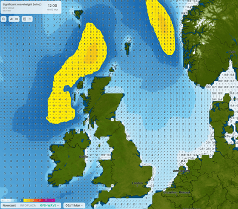 Figure 2: Significant wave height in meters according to the American GFS wave model on Wednesday March 13th at 12 UTC.
On Thursday, winds are expected to drop to moderate over the northern North Sea by the end of the day. The rest of the North Sea will continue to experience moderate to strong winds, 4-6 Beaufort. Waves will gradually drop to 1 – 2 meters in general, and locally still reaching 3 meters in the northern North Sea. These wave heights will continue on Friday.
As next low pressure moves across the northern North Sea late Friday and Saturday, winds are again expected to increase to (near) gale force over the northern North Sea. The European ECMWF model forecasts even higher winds up to strong gales Saturday afternoon. Highest winds are expected on the northern and western flanks of this low pressure. The rest of the North Sea will mostly experience strong to near gale conditions, with the lowest wind speeds over the southern North Sea. Waves are again expected to reach up to 4 – 6 meters over the northern North Sea and 3 – 5 meters over the central North Sea. The southern North Sea remains relatively calm with mostly 1 – 2 meters.
Late Saturday and early Sunday, winds are temporarily expected to become gentle to moderate before picking up again later on Sunday.
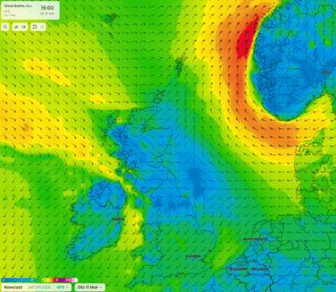 Figure 3: Wind speed in knots according to the American GFS model on Saturday March 16th at 16 UTC.
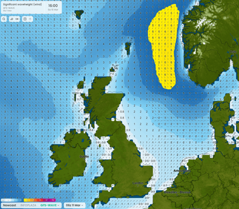 Figure 4: Significant wave height in meters according to the American GFS wave model on Saturday March 16th at 16 UTC.
Conclusion
Multiple low pressure areas will be crossing the North Sea this week. The weather will be rather unsettled during the coming days. However, in between the passing lows, weak ridges will stabilize the weather for short periods of time. The most active weather is forecasted along the SW coast of Norway on Saturday. Over the far south of the North Sea it is generally much calmer, possibly resulting in good workable windows from time to time.
Always up-to-date
Like this weather briefing? Our monthly newsletter gives you even more insights. Think about the marine weather phenomena, updates about our ever-evolving forecasting products, and the latest and most relevant marine weather briefing. Subscribe to receive our Infoplaza marine newsletter once a month.