At the start of the week, some small low-pressure areas move over the North Sea area. This causes some low confidence and uncertainties in wind speed and wave height. During the weekend, high pressure takes over, followed by new frontal systems afterward. However, this is more straightforward. Read all about it in this blog.
Synoptic overview
In the course of Tuesday and the night to Wednesday, a small-scaled low-pressure area moves over the central and southern North Sea area. This causes uncertainties in wind speed and waves. In the meantime, a low-pressure area over the Norwegian Sea quickly moves north, while a high-pressure area takes over on Wednesday and Thursday over the northern North Sea area. This causes relatively calm weather for your operations.On Thursday evening and the night to Friday, another small low-pressure area moves over the North Sea area. Because of its small scale, it is highly uncertain at the moment. This will probably cause a low confidence situation over the southern and central North Sea. On Friday and Saturday, high pressure takes over again over the whole North Sea area, followed by frontal systems from the west on Sunday and Monday.
Video briefing with marine meteorologist Arjan Willemse at the end of this article
Wind and waves this week
Figure 1 shows the wind speed and wind direction according to the American weather model GFS on Wednesday at 06:00 UTC. The small-scaled low-pressure area is clearly visible in the wind. We see a strong southwesterly wind over the southern North Sea but a mainly east to northeasterly wind on the central North Sea. The small scale of this low makes the forecast difficult for your operation. A small shift can make a big difference in this case. We will monitor this closely, of course, but be aware of low confidence.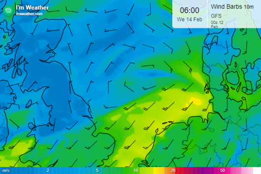
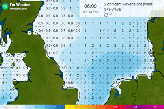
The corresponding significant wave height is interesting as well. On the southern part of the previously mentioned low, we see wave heights (Hs) around 2-3 meters. On the northern flank, we see 1-2 meter Hs and just in the center of the low, we find still conditions. However, this could also shift in the coming days. Be aware of this situation if it occurs in your area of interest.
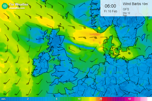
A similar situation occurs on Friday morning when a low from the British Isles moves towards Denmark while passing the North Sea area. We see a strong easterly wind south of Norway and a southerly wind just North of the Dutch coast. In between, an area of variable weak winds occurs. All said before is valid for this situation as well. Be aware of low confidence in your area and the possible changes in the forecast.
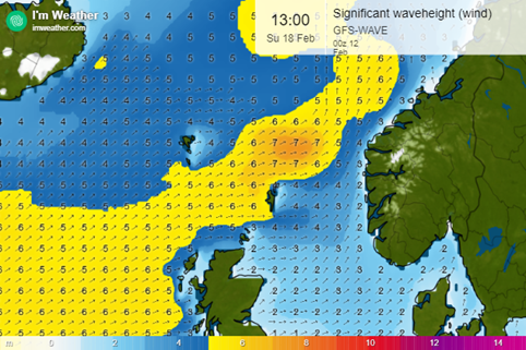
In the course of the weekend, we see frontal systems approaching from the west, which causes more wind and especially higher wave heights. In the figure below, we see wave heights over 6-7 meters over the northern North Sea area. This could definitely cause waves exceeding limits. This forecast is much more in the future, but these systems are larger and easier to predict. This means that the certainty of this situation is much clearer than with the small-scale low-pressure areas.
Conclusion
In general, we can detect three different patterns in the forecast for next week. First of all, we have two uncertain situations with small-scaled low-pressure areas. This could cause low confidence for some locations over the North Sea. Afterward, high pressure takes over which causes calm weather over the North Sea. In the course of the weekend, frontal systems will cause more unsettled conditions, especially over the northern North Sea area. In conclusion, then, we can describe this week as dynamic with uncertainties but without too many outliers.
Always up-to-date
Like this weather briefing? Our monthly newsletter gives you even more insights. Think about the marine weather phenomena, updates about our ever-evolving forecasting products, and the latest and most relevant marine weather briefing. Subscribe to receive our Infoplaza marine newsletter once a month. 

