Today and early Wednesday, the North Sea benefits from a ridge of high pressure, resulting in mostly moderate to fresh winds. However, as the week progresses, several active troughs and approaching low-pressure systems will bring more challenging conditions, with increasing wind speeds and wave heights. Read on for a detailed overview in this blog.
Synoptic overview
Tuesday into Wednesday, a weak ridge of high pressure, associated with a high-pressure system over the Bay of Biscay, will shift eastward over the North Sea.
By Wednesday, an active trough, linked to a low-pressure system near Iceland, will move eastward across the area. Gale force winds are expected in the northern North Sea, while further south, winds are anticipated to increase to near gale.
Thursday and Friday will see the low-pressure system approach Scotland and the northern North Sea, maintaining unsettled conditions with a risk of gales during the passage of troughs.
By the weekend and into Monday, forecasts become uncertain, particularly regarding wind speeds and wave heights. Low-pressure areas are forecasted to be near or over the North Sea, leading to ongoing unsettled conditions. Confidence in wind speed and wave height forecasts for this period is low, as the precise development and position of the lows and troughs will significantly impact conditions. The risk for gales persists near active lows and troughs, although calmer conditions may occur intermittently.
You can find a video briefing at the end of this article.
Wind and waves
Figure 1 shows the wind speed and wind direction according to the American weather model GFS on Wednesday at 12:00 UTC. A crossing trough results in gale force winds in the northern North Sea, while further south, winds are not expected to exceed near gale levels. By the afternoon, the gales will move eastward towards the Norwegian coast.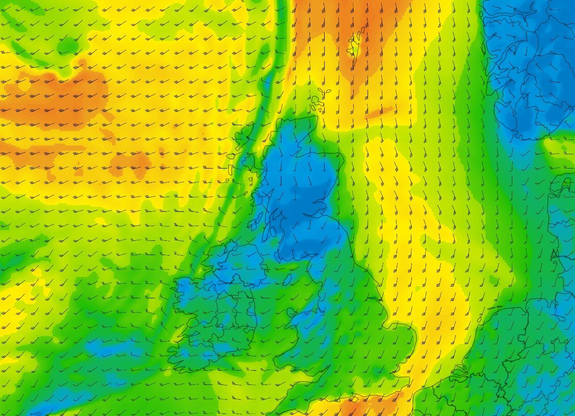 Figure 1: Wind speed and wind direction according to GFS on Wednesday February 21st at 12 UTC.
The significant wave height shows waves around 2-3 meters over large parts of the North Sea. Despite southerly flow and limited fetch, along with the swift passage of the trough, the sea state remains moderate to rough. Very rough seas, with wave heights of 4-6 meters, are expected in the far north and west of the Shetlands.
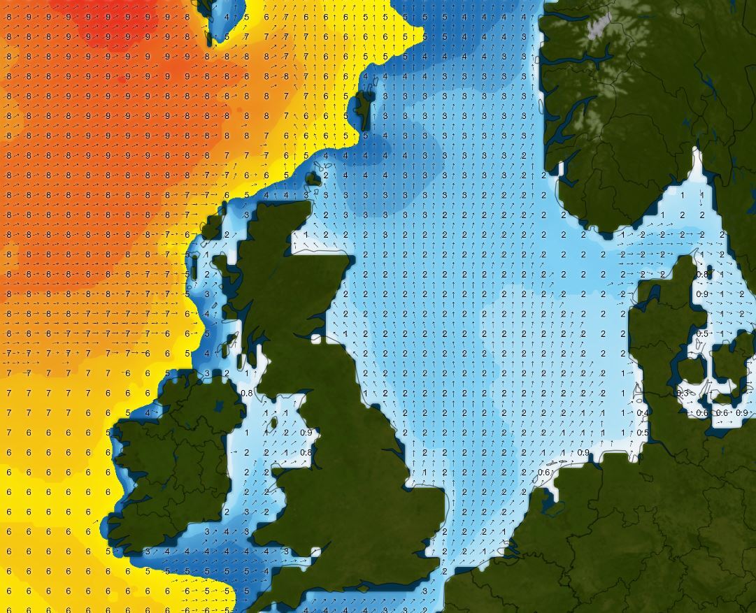 Figure 2: Wave height according to GFS on Wednesday February 21st at 12 UTC.
Conditions will temporarily improve on Thursday morning following the passing trough, but deteriorating conditions are expected again later in the day with the arrival of the next trough. Gale force winds may reoccur in the far north and near the Norwegian coast.
Towards the weekend the low approaches Scotland. On the east side of the low the winds will increase again, potentially reaching gale force in the northern North Sea. This time, strong winds will persist for an extended period, resulting in very rough seas with wave heights 4-6 meters over large parts of the northern North Sea.
The track and development of the low-pressure system remain uncertain, with minor differences potentially having a significant impact on conditions over the North Sea area. Stay updated with our latest forecasts for the most accurate weather prognosis in your area.
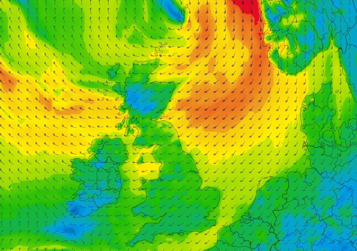 Figure 3: Wind speed and wind direction according to GFS on Saturday February 24th at 12 UTC.
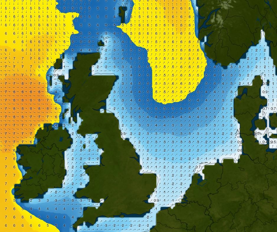 Figure 4: Wave height according to GFS on Saturday February 24th at 12 UTC.
Sunday and Monday's forecasts remain uncertain, with low-pressure areas lingering near or over the North Sea, resulting in ongoing unsettled conditions. The risk of gales persists near active lows and troughs, although calmer conditions may prevail intermittently.
Conclusion
Tuesday and early Wednesday will see relatively calm weather over the North Sea due to a weak ridge of high pressure. However, from Wednesday onwards, an ongoing chain of troughs and lows will traverse the area, leading to unsettled conditions with intermittent risks of gales, especially in the northern North Sea. Periods of temporary calmness may occur between these systems.
Always up-to-date
Like this weather briefing? Our monthly newsletter gives you even more insights. Think about the marine weather phenomena, updates about our ever-evolving forecasting products, and the latest and most relevant marine weather briefing. Subscribe to receive our Infoplaza marine newsletter once a month.