AI-assisted | Reviewed by R. Klaassen, Senior Meteorologist
After a period of La Niña conditions and a relatively neutral ENSO climate in 2024, 2025, climate scientists worldwide are turning their attention to the Pacific Ocean. The question is growing louder: is a new El Niño on the horizon for the second half of 2026?
What Are the Models Saying?
NOAA/CPC: Cautious Signals Towards El Niño
The American Climate Prediction Center (NOAA/CPC) indicates in its most recent ENSO outlook that the probability of El Niño development during 2026 is gradually increasing. SST anomalies (sea surface temperature deviations) in the central and eastern Pacific, particularly in the Niño 3.4 region, are currently moving towards the +0.5°C threshold that marks El Niño watch territory.
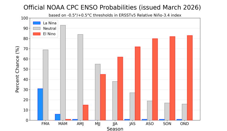
Source: NOAA. ENSO Forecast per 3 months
NOAA reports a probability of approximately 50-60% for El Niño conditions during meteorological autumn 2026 (August, October). An important caveat: models perform worst in spring, the well-known spring predictability barrier. Forecasts made now for the period after summer should therefore be read with appropriate caution.
Bureau of Meteorology (BoM): Neutral with an Upward Signal
Australia's Bureau of Meteorology maintains its own ENSO outlook and currently reports ENSO-neutral conditions, but points to an upward trend in ocean-atmosphere coupling. The Cold Tongue in the eastern Pacific is weakening, and the Trade Winds show signs of relaxation, both classic precursors to an El Niño cycle.
BoM's probability for El Niño later in 2026 sits around 50%, just above the climatological base rate of roughly 25%. That is statistically significant, but not yet cause for alarm.
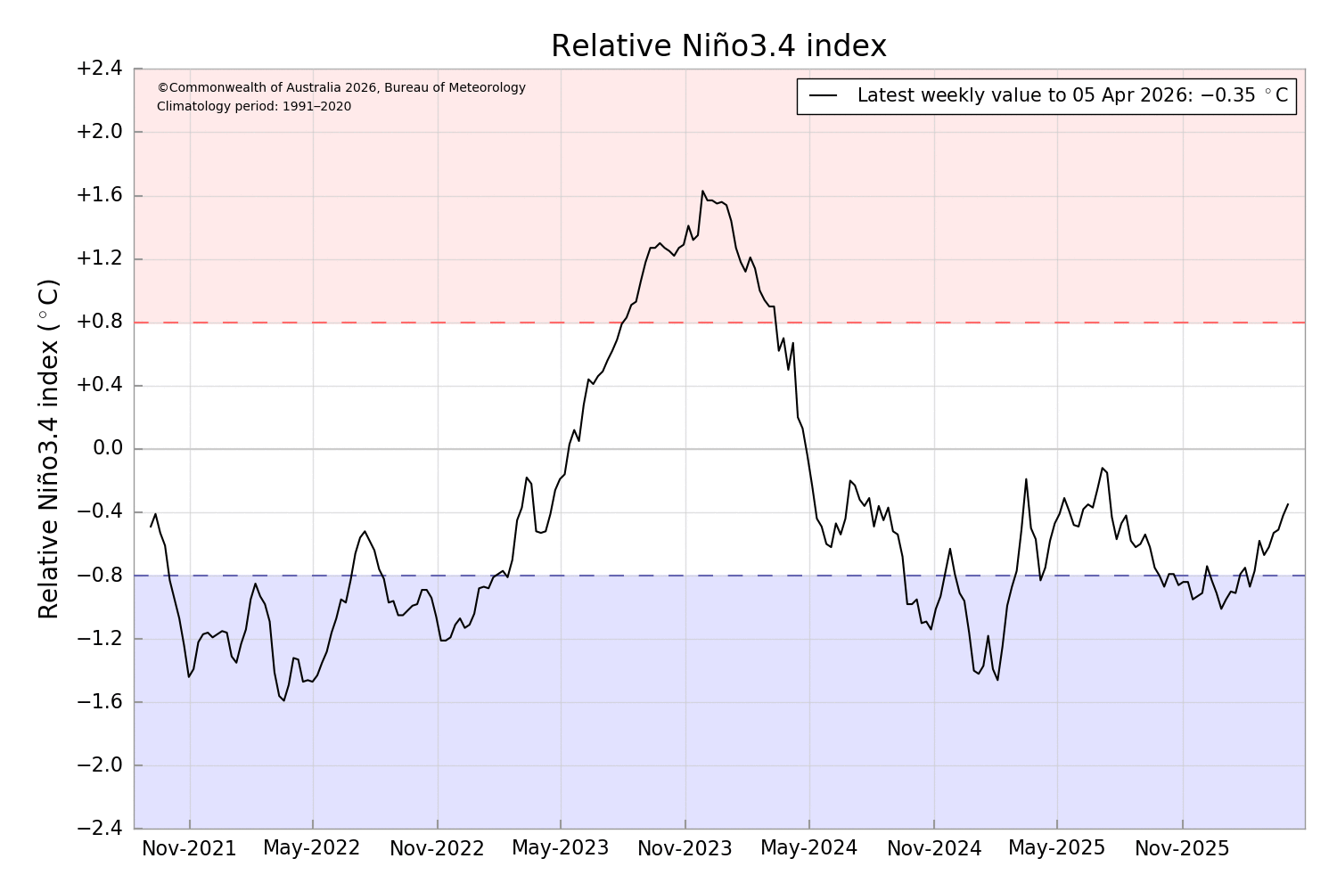
Relative Niño 3.4. Source: BoM
Copernicus/ECMWF: Ocean Heat as a Wild Card
The Copernicus Climate Change Service (C3S), based on ECMWF modelling, adds an important dimension. Due to the persistently high global ocean temperatures driven by human-induced climate change, the Pacific is in a precarious equilibrium. Even a weak El Niño on top of an already-warm baseline can produce anomalies that previously would only have been associated with a strong episode.
ECMWF ensembles show a spread ranging from neutral to moderate El Niño for Q3-Q4 2026. The median run leans towards weak El Niño conditions, but uncertainty remains high.
The Oceanographic Context: Why Pay Attention Now?
Anyone looking at subsurface temperature data from the Pacific via the TAO/TRITON buoy array will notice that warm water sitting deeper in the ocean, a so-called Kelvin wave, is slowly propagating eastward. Kelvin waves are the silent messengers of El Niño: they transport warm water from the western Pacific towards the South American coast, and could push SST anomalies further upward in the coming months.
This resembles the situation in spring 2023, which preceded the strong El Niño of 2023, 2024, although the current oceanic heat content is currently less pronounced than it was at that point.
 ENSO forecast by several Institutes. Source: Copernicus
What Would a Potential El Niño Mean for Our Weather?
An El Niño in the second half of 2026 would leave its mark globally:
- Northwestern Europe: El Niño winters are statistically more often mild and wet in our region, though the link is indirect and variable. The NAO (North Atlantic Oscillation) plays a significant mediating role.
- Mediterranean region: increased probability of a wetter autumn and winter.
- Tropics: elevated drought risk in Australia, Indonesia and parts of Africa; above-average rainfall in Ecuador and Peru.
- Atlantic hurricane activity: El Niño typically suppresses the Atlantic hurricane season through increased wind shear in the upper troposphere.
- Global temperatures: a new El Niño will almost certainly drive new record-high global average temperatures, on top of the already elevated climatological baseline.
Conclusion: Watchful Waiting
The signals are present, but not yet decisive. Three leading institutions, NOAA, BoM and Copernicus/ECMWF, all point in the same direction: the odds of El Niño later in 2026 are above average, but a neutral outcome remains well within reach.
The coming months are critical. Once we move past the spring barrier of April, May, forecasts will become considerably more reliable. The monthly updates published by NOAA and BoM, available at weather.gov, bom.gov.au and climate.copernicus.eu, deserve close attention in the months ahead.
Sources: NOAA/CPC ENSO Outlook (April 2026), BoM ENSO Outlook (April 2026), Copernicus/C3S Seasonal Forecast, TAO/TRITON subsurface data.