High pressure over Scandinavia has vanished. At the same time, high-pressure is building over the Azores, while low pressure is still present near Iceland. A westerly to southwesterly flow is developing in between those two pressure systems. As a result, frontal troughs will frequently reach the North Sea during this week. Weak ridges of high pressure will follow in between the passing troughs, resulting in some workable windows.
Video briefing at the end of this article.
Synoptic overview
A high-pressure area is located near the Azores while an associated ridge is tracking east over the North Sea today, resulting in calm weather conditions. Meanwhile, a low-pressure area is located just south of Iceland indicating that and associated frontal trough will track east over the UK and the North Sea on Wednesday and early Thursday. The southern half of the North Sea is still relatively close to the high-pressure area, and therefore the front will be the weakest there. A new ridge will follow in its wake.A new low-pressure area is located between Iceland and Scotland on Saturday while an associated frontal trough tracks east over the North Sea on that same day. This frontal trough will be stronger than the previous one. The most active weather will occur again over the northern half of the North Sea, closest to the low-pressure core.
Wind and waves
Figure 1A shows the ridge tracking eastward over the North Sea during the night to Wednesday. The weather in the ridge is relatively calm, resulting in good workable conditions. The ridge is quickly followed by a weak frontal trough, but the passing trough results in only a slight increase in wave height. Hs will probably be around or just below 1.5m at most locations over the North Sea (Figure 1B). The lowest Hs values will occur along the east coast of the UK as the UK provides a sheltering effect from the westerly wind. Wind speed may briefly increase to 25 or 30 kts over the middle and northern half of the North Sea.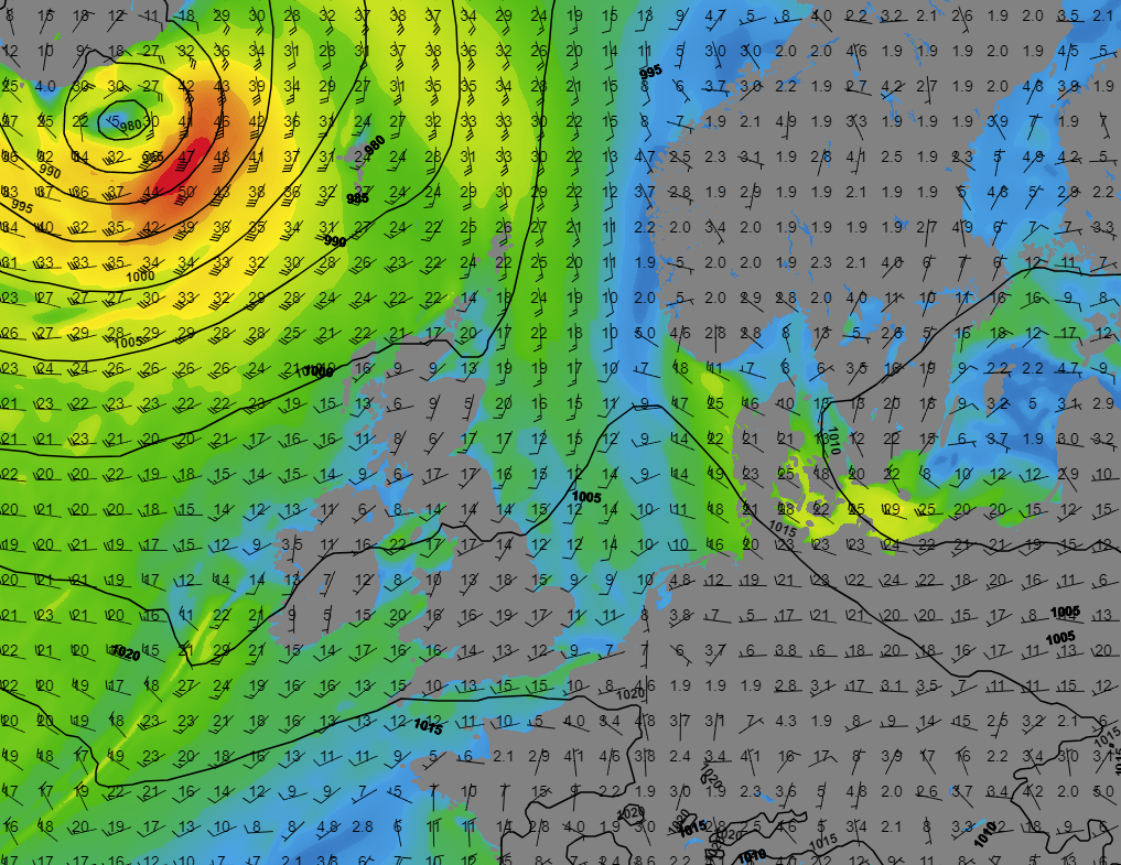 Figure 1A: Sea level pressure (black lines), wind direction (barbs) and wind speed (colors) on Wednesday 00UTC.
 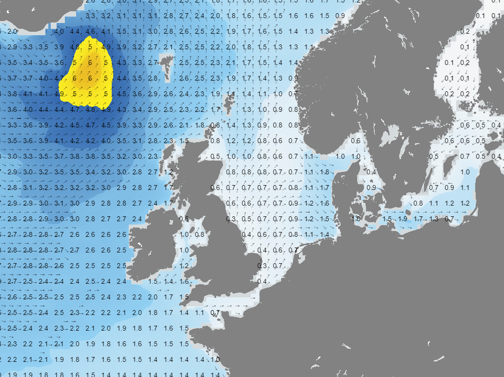 Figure 1B: Significant wave height and direction on Wednesday 00UTC.
A second, and more active, trough will pass east over the North Sea during the weekend. The front will once again be the most active over the northern half of the North Sea, closest to the associated low-pressure core. Figure 2A shows that wind gusts might reach 40 kts, and Hs will reach up to 3 meters during the passage of the trough (Figure 2B). The frontal trough will be weaker over the southern half of the North Sea since it is closer to the high-pressure system over the Azores. Wind gusts up to 25-30 knots are expected over the southern half. 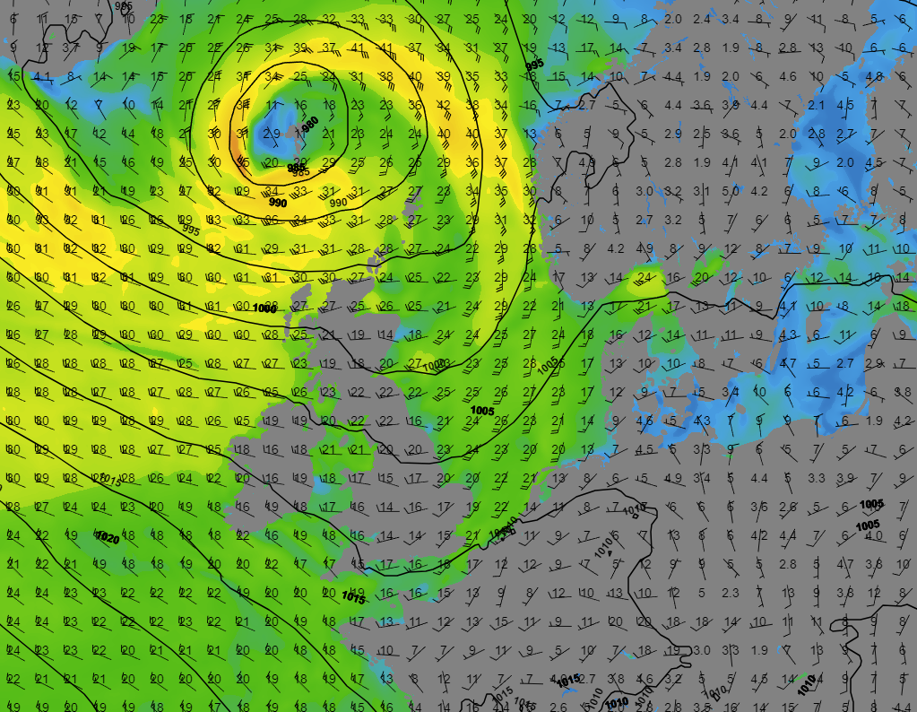 Figure 2A: Sea level pressure (black lines), wind direction (barbs) and wind speed (colors) on Saturday 09UTC.
 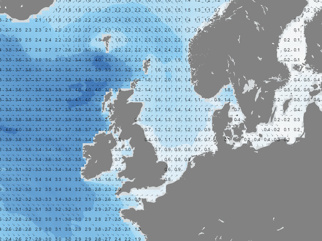 Figure 2B: Significant wave height and direction on Saturday 09UTC.
Conclusion
Although there will be passing frontal troughs, there will be plenty of workable conditions during large parts of this week. The first frontal trough passing on Wednesday will be a relatively weak, resulting in minimal increase in both wind and waves. However, the trough passing on Saturday will be a stronger, especially over the northern half of the North Sea. Winds might gust up to 30-40 kts, and significant wave height will increase to 3 meters. The frontal trough will be less active over the southern half of the North Sea.
Weekly weather briefing
Every week we will post an updated weather briefing on the Infoplaza website and the Infoplaza Marine Weather Operations LinkedIn page. We will also share weather related articles and topics on offshore weather on these pages. We hope all our clients stay safe this week. Please feel free to contact us at any time if you have any questions or remarks. 


