The winter is slowly coming to an end. However, any spring weather is totally absent in this week’s forecast. Low-pressure systems dominate over large parts of the North Sea during this week, often resulting in unsettled weather associated with strong winds and high waves. As a result, safe operational weather windows will be scarce.
Synoptic overview
A low over Scandinavia tracks NE, while slowly filling up. A weak ridge will build over the UK in the meantime. In between the low and the ridge, a northwesterly flow will build over the North Sea. As the ridge shifts E across the North Sea on Wednesday, wind and waves will decline due to a weaker pressure gradient. Meanwhile, a new and active low-pressure system formed over the Atlantic Ocean will reaches the North Sea on Thursday. An additional, but probably weaker, low-pressure area reaches the southern North Sea on Friday. This low slowly fills up there over the weekend.
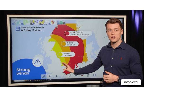
You can find the video briefing at the end of this article.
Wind and waves
As a low-pressure area tracks NE over Scandinavia and a weak ridge builds over the UK, a northwesterly flow builds over the North Sea. Due to a combination of strong winds of up to 35 kts, relatively cold upper air and a long fetch, significant wave height (Hs) could build up to 5 meters in height over the northern and middle parts of the North Sea as shown in the image below (please see Figure 1). Only the very S of the North Sea, near the English Channel, will remain free of most of the high waves due to its sheltered location in a northwesterly flow.
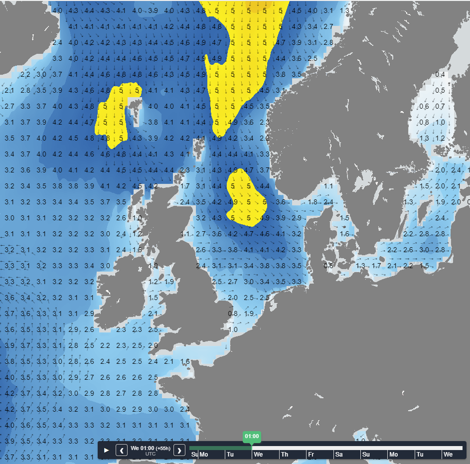 Figure 1: Hs over the North Sea on Wednesday 01UTC according to GFS.
Both wind and waves will calm on Wednesday as weak ridge tracks E over the North Sea. Significant wave height remains above 2.5 meters well offshore, but close to the Dutch, German and Danish coastlines, some workability might be possible as Hs is expected to slowly drop below 1.5 meters at most locations.
However, both winds and waves will pick-up quickly again on Thursday as a low-pressure system located over Scotland encroaches (please see Figure 2). On the eastern and northeastern half of the low-pressure system, core winds up to 35-40 kts might be possible again.
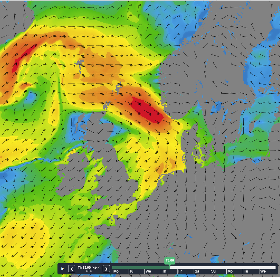 Figure 2: Wind speed and direction over the North Sea according to GFS for Thursday 13UTC.
Due to the strong winds and long fetch the significant wave height will pick up again as well, which can be seen in Figure 3. Due to the south- southwesterly flow over the southern part of the North Sea, the E coast of the UK is expected to experience the least hinderance from the weather, as the UK acts as a large wind breaker.
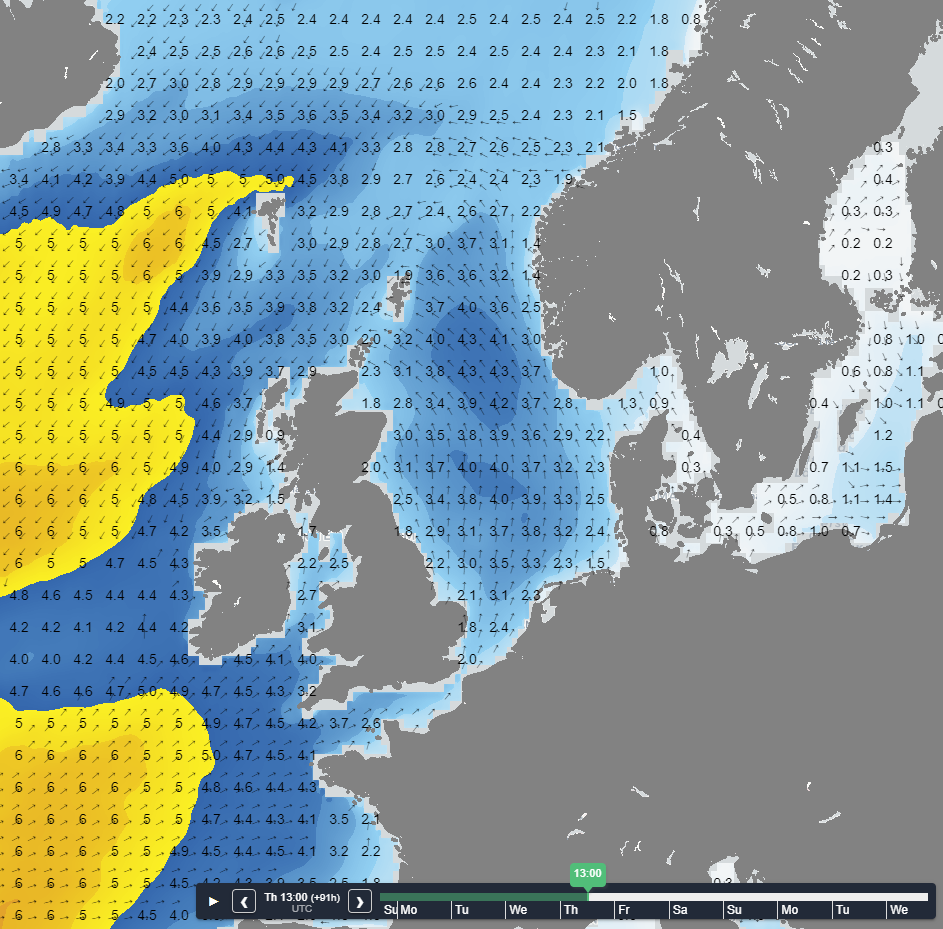 Figure 3: Significant wave height and direction over the North Sea according to GFS for Thursday 13UTC.
Conclusion
Various low-pressure systems cause unsettled conditions over a large part of the North Sea. Wednesday seems the best day to achieve some workability close to the Dutch, German and Danish shore. However, the weather will quickly deteriorate on Thursday, putting most weather sensitive operations on hold.
Weekly weather briefing
Every week we will post an updated weather briefing on the Infoplaza website and the Infoplaza Marine Weather Operations LinkedIn page. We will also share weather related articles and topics on offshore weather on these pages. We hope all our clients stay safe at sea this week. Please feel free to contact us at any time if you have any questions or remarks.


