Last week, low pressure dominated the weather over the North Sea, with multiple frontal troughs crossing the area. This week’s weather looks completely different, with high pressure extending a ridge over the North Sea. However, on Thursday and Friday low pressure will cross the North Sea, with an increase in winds and waves as a result.
You can find a video briefing at the end of this article
Synoptic overview
High pressure is located over the eastern part of the North Sea and Scandinavia on Tuesday, extending a ridge over the entire area of the North Sea. The core of the high pressure tracks eastward over the following days, towards Western Russia. In the meantime, low pressure is located east of Iceland, tracking northeast. An associated frontal trough is present near the UK on Tuesday and Wednesday. The frontal trough spawns a secondary low in the night to Thursday, crossing the North Sea on Thursday and Friday. The exact track and development of the low is uncertain. The American model GFS shows a more northerly path and more deepening of the low than the European model ECMWF.In this case the ECMWF scenario seems to be supported by other models as well. In the wake of the low-pressure system, high pressure will rebuild over the UK and Scandinavia and a ridge will take over the North Sea again.
Wind and waves
Under the influence of the high-pressure system, winds and waves will generally be low on Tuesday and Wednesday. Over the course of Wednesday, the frontal trough will affect the Northern North Sea. Winds will increase to 30 kts (please see Figure 1) over the northern parts of the North Sea, with significant wave heights increasing to 2.5 – 3.0 meters. In the central parts of the North Sea, winds will remain below 15 kts and waves between 1.0 and 1.5 meters. In the Southern North Sea, waves will not exceed 1.0 meter, with wind speeds below 10 kts. Along the Dutch coastline and in the German Bight, significant waves height values of 0.1 to 0.5 meter are expected (please see Figure 2).
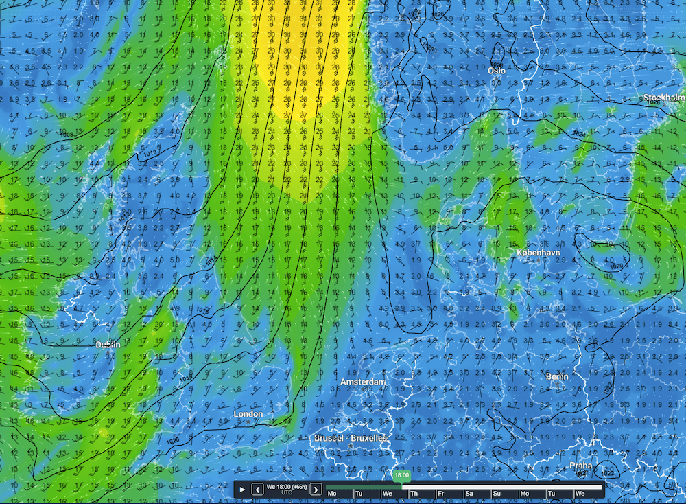 Figure 1: Isobars (black lines) and wind direction and wind speed in kts on Wednesday at 18 UTC.
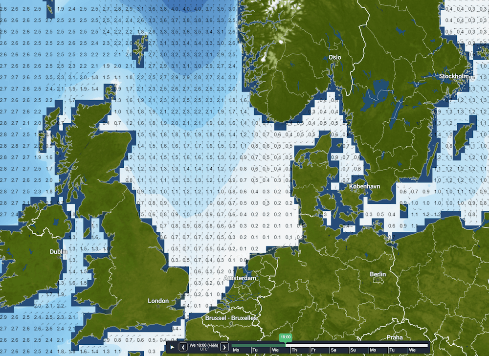 Figure 2: Significant wave height and direction on Wednesday at 18 UTC.
On Thursday, the area with higher wind and waves will propagate more towards the south. Waves will increase to 3.0 meters in Viking and the northern part of Forties. The exact development of the low-pressure area that will develop in the night to Thursday is uncertain. In the GFS scenario, winds will increase to 30 kts in the Central North Sea and waves can grow up to 2.5 – 3.0 meters behind the trough (please see Figure 3 and 4). In the ECMWF scenario, the low will track over the most southern parts of the North Sea and will the pressure in the core will be higher. Therefore, winds and waves will not increase as much as in the GFS scenario. Winds will increase to 20 kts and waves will hardly grow above 1.0 meter.
Since the ECMWF scenario is supported by other models as well, we think this scenario is more likely to occur. But bear in mind that the confidence is rather low, so please take this advice with caution.
On Friday, the low pressure will move away to the southeast while filling. Winds will decrease again and waves will generally not be higher than 1.5 meter. Only in the most northerly part of the North Sea, waves can grow until 2.5 meter. During the weekend, waves will grow even less and will not exceed 1.0 meter in the majority of the North Sea area.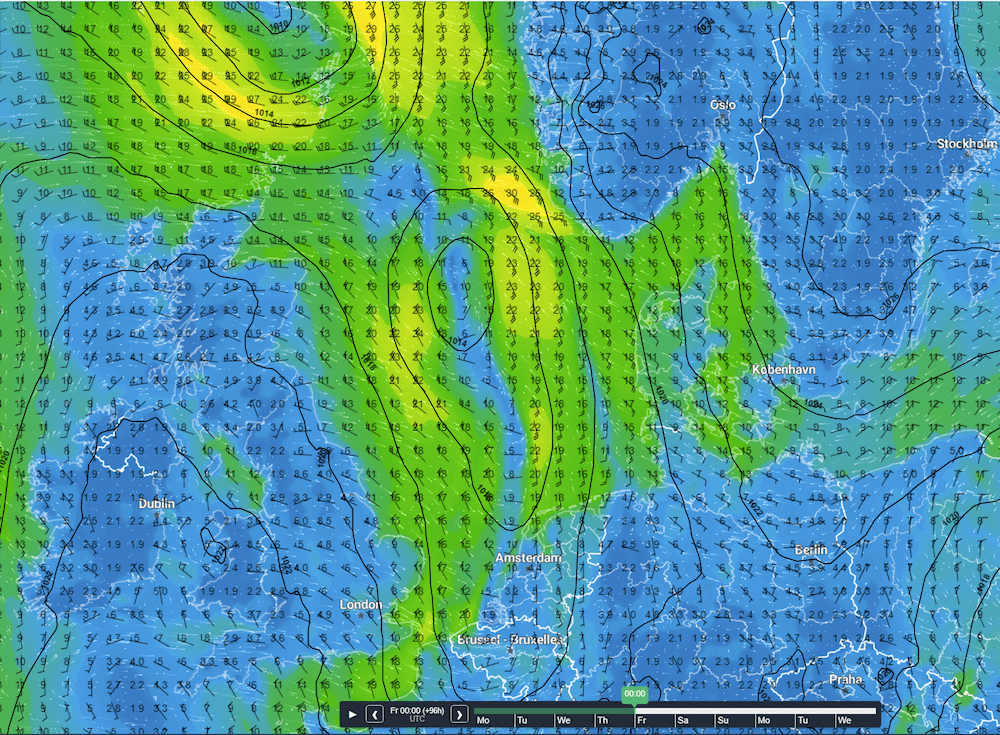 Figure 3: Isobars (black lines) and wind direction and wind speed in kts on Friday at 00 UTC.
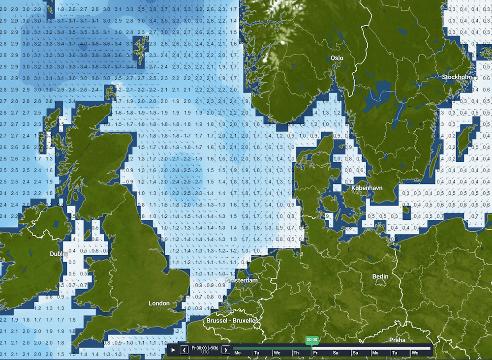 Figure 4: Significant wave height and direction on Friday at 00 UTC.
Conclusion
High pressure is located over Scandinavia, with a ridge stretching over the North Sea for the majority of this week. The high pressure influence is alternated with a situation where a frontal trough will spawn a separate low in the night to Thursday. The different weather models show a different track and development of the system.
We follow the ECMWF scenario in which the low-pressure area tracks over the Southern North Sea with a less pronounced wind peak than in the scenario where the low pressure area tracks over the Central North Sea. Bear in mind that the uncertainty is quite high. Please check you daily forecasts as confidence will grows approaching the event
Afterwards, high pressure regains influence over the area and calm conditions occur. Overall, this week is characterized by rather calm and stable weather, with workable conditions.
Weekly weather briefing
Every week we will post an updated weather briefing on the Infoplaza website and the Infoplaza Marine Weather Operations LinkedIn page. We will also share weather related articles and topics on offshore weather on these pages. We hope all our clients stay safe at sea this week. Please feel free to contact us at any time if you have any questions or remarks.