A low-pressure area over southern Scandinavia slowly moves ENE, while a ridge of high pressure over the UK slowly shifts NE across the North Sea over the next few days. Later this week and in the weekend Atlantic low pressure activity gains influence from the SW as associated troughs move into the (southern) North Sea. As the winds and waves will gradually decrease over the coming days from the west, the chances of workable weather windows are expected to improve.
Synoptic overview
A low-pressure area (995hPa) over southern Scandinavia slowly moves ENE the coming days. A strong high-pressure area near Iceland extends a ridge SE across the UK at the same time, slowly drifting NE across the central North Sea in the second half of this week and across the northern North Sea over the weekend. A frontal trough, associated with a deep low over the Atlantic, moves ENE across the southern North Sea on Friday while possibly developing into a separate low-pressure centre. Another trough will most likely move ENE across the UK and into the central North Sea during the weekend.Skip to the video briefing at the end of this article
Wind and waves
In between the ridge of high pressure over the UK and the low over Scandinavia, a firm NW’ly flow is present over the North Sea. Strong to near gale force NW’ly winds (25-35kts) will result in significant waves between 3.5 and 4.5m today. Wind and waves will gradually decrease from the west over the coming days, as the ridge gradually shifts NE across the North Sea. Calm conditions with gentle to moderate winds (5-15kts) and a significant wave height dropping (well) below 2m, will dominate the weather for the greatest part of the North Sea on Friday and throughout the weekend. The possible development of the separate low over the southern North Sea results in some uncertainty on Friday, but at this stage no significant deepening is expected to take place.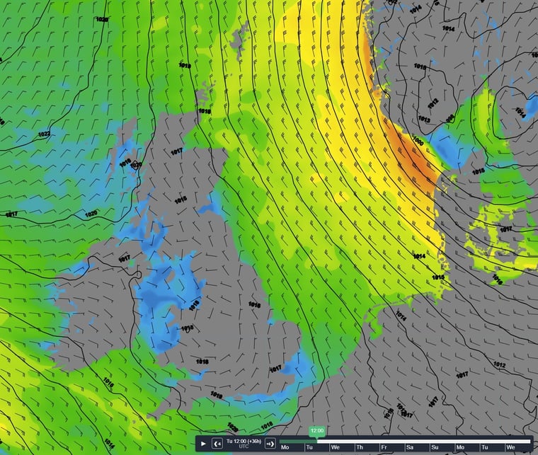 Figure 1: Isobars (black lines 5hPa) and wind speed/direction (kts) valid Tuesday April 25th 12 UTC.
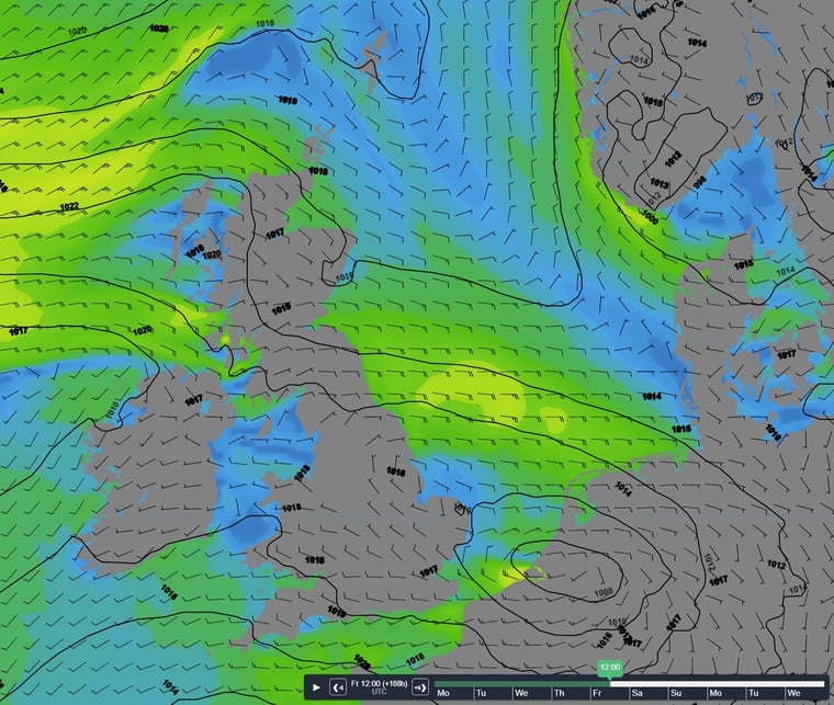 Figure 2: Isobars (black lines 5hPa) and wind speed/direction (kts) valid Friday April 28th 12UTC.
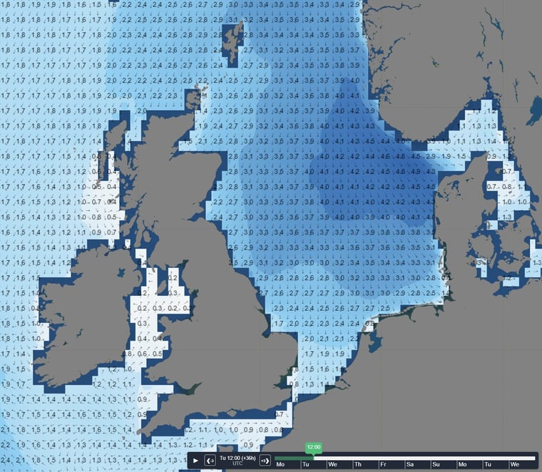 Figure 3: Significant wave height/direction (m) valid Tuesday April 25th 12UTC.
Conclusion for week 17
The actual firm NW’ly flow over the North Sea will gradually weaken over the coming days, as the low-pressure area over Scandinavia and the ridge of high pressure over the UK both slowly shift E/NE. Later this week and over the weekend Atlantic low pressure activity gains more influence from the SW, but at this stage no major developments that may result in strongly enhanced wind and waves are expected to take place. However, Infoplaza will continue to monitor the latest weather developments, so please make sure to check, and follow-up our daily updated forecast reports to check the latest developments. The risk of low clouds and/or fog will remain marginal for the greatest part of the North Sea this week. Only the southern parts of the North Sea will see an increasing risk later this week and during the weekend as milder and more humid air will be transported into the area.
Weekly weather briefing
Every week we will post an updated weather briefing on the Infoplaza website and the Infoplaza Marine Weather Operations LinkedIn page. We will also share weather related articles and topics on offshore weather on these pages. We hope all our clients stay safe at sea this week. Please feel free to contact us at any time if you have any questions or remarks.