It is no longer all about high pressure this week, though conditions over the North Sea will not become adverse immediately. Many working opportunities are still expected this week. Wind and waves will remain relatively calm, although there will be some frontal troughs moving over. Especially the northern North Sea will experience increased wind and waves on Thursday as low pressure moves northeastward, passing just south of the Faroe Islands. On Sunday, low pressure is expected to settle over the UK, which will affect the entire North Sea next week.
Synoptic overview week 37, 2023
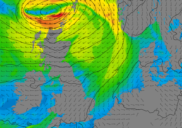
A thermal low-pressure system over Germany is moving northeastward today and will reach the Baltic states tomorrow. An associated trough over the southern North Sea will result in showery conditions in this area today. At the same time, high pressure is strengthening west of Ireland today, and will pass over the UK tonight, settling over the North Sea tomorrow. High pressure will move further east into the Baltic Sea on Thursday, while a low-pressure system (995 hPa) moves northeast between Scotland and the Faroe Islands. Higher winds and waves will primarily affect the area well north of Humber.
Low pressure will reach the Norwegian Sea on Friday, while its frontal zone still drags over the central North Sea. Conditions over the northern North Sea will calm down by then, and will remain calm as high pressure develops over the Shetland islands on Saturday. The aforementioned frontal zone will slowly dissipate on Saturday as well. High pressure will shift eastward into Scandinavia on Sunday, while low pressure will move into the UK. On the approach of this low pressure, southeasterly winds will intensify across the entire North Sea. This low-pressure system is likely the beginning of a more unsettled weather pattern that will persist into next week.
Wind and waves in the North Sea
Despite the increased influence of low-pressure systems this week, conditions will not immediately deteriorate across the entire North Sea. With low pressure over Germany and high pressure approaching from the west, the pressure pattern tightens to the south of Dogger and over the German Bight later today. An area of fresh to strong winds (18-25 kts) is expected over Humber and the German Bight later today, shifting south across Thames and Dover tonight and tomorrow morning. Similar conditions are expected over Fisher during this evening and into much of tomorrow. Significant wave heights will increase to around 2.0 meter over the southern areas. The area just west and south of Norway will experience waves of around 2.5 meters. Waves of around 1.5 meters are expected throughout the rest of the North Sea. Wednesday will see high pressure extending over the North Sea, with winds temporarily dropping below 10 kts and a slight decrease in wave heights.
Late Wednesday, winds will again intensify from the west as Atlantic low pressure approaches Scotland. Its cold front will cross the central and northern North Sea on Thursday, with winds picking up to just over 25 kts along the front. Fair Isle, Viking and N. Utsire will experience up to 30 kts of wind. The southern North Sea remains relatively calm with local fresh winds over Humber. Along the cold front, waves will reach up to 2.5 meter over the central North Sea and up to 3.0-3.5 meter in the northernmost areas. Strong winds will persist well into Friday over the northern areas as low pressure moves into the Norwegian Sea, while conditions come down over the central North Sea late Thursday already.
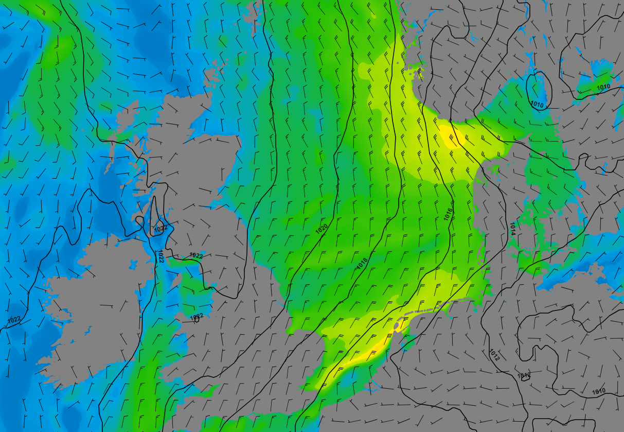
Figure 1: Isobars (black lines 5hPa) and wind speed/direction (kts) valid Wednesday, September 13th, 00 UTC. High pressure approaches from the west, while low pressure is present over Germany and southern Scandinavia. This tightens the pressure pattern over the southern and eastern North Sea.
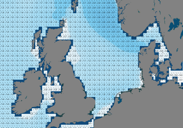
Figure 2: Significant wave height/direction (m) valid Wednesday, September 13th, 00 UTC. Wave height increases in the areas around Norway, Denmark and the Netherlands.
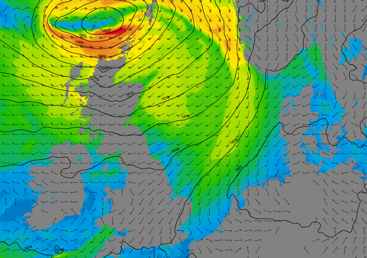
Figure 3: Isobars (black lines 5hPa) and wind speed/direction (kts) valid Thursday, September 14th, 12 UTC. Low pressure is present between Scotland and the Faroe Islands, moving northeast towards the Norwegian Sea. Frontal zones affect the northern and central parts of the North Sea.
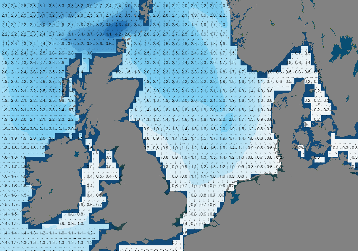
Figure 4: Significant wave height/direction (m) valid Thursday, September 14th, 15 UTC. Waves increase around the passing cold front. The southern North Sea remains fairly calm.
On Friday, a trough continues to linger over the central North Sea. Winds will mostly fluctuate around 15 knots, but 20-25 kts northeasterly winds are expected in a band over Forties, Forth and further southwest into the Irish Sea later that day. The significant wave height is likely to increase to around 2.0 meter, while most of the other areas see waves dropping to around or just below 1.0 meter on Saturday. On Sunday, winds are between 10-15 kts over much of the North Sea, except for Forth which will still experience more. High pressure will eventually shift towards Scandinavia and low pressure is expected to move into the UK. Southeasterly winds are expected to intensify across the entire North Sea, primarily staying in the fresh wind range. Waves will gradually increase again to 1.5-2.0 meter. Further low-pressure systems are expected to impact the North Sea next week.
Conclusion for this week
This week appears to be a transition to a more unsettled weather pattern next week. A few low-pressure areas are already affecting parts of the North Sea this week, but there are still many opportunities to carry out operations.
Learn more about the weather
We just launched our new resources page. Here you will find special content like videos, webinars and whitepapers that will guide you to a decision point. Use these expert insights to improve your business or simply to get your knowledge about marine weather up-to-date.