High-pressure is located over the central North Sea on Tuesday, while low-pressure moves into northern Scandinavia. The high-pressure area moves NNE on Tuesday and Wednesday, into the Norwegian Sea and into Scandinavia afterwards. In its wake, a low-pressure west of the Bay of Biscay moves north, merging with an Atlantic Low on Wednesday. The system affects the North Sea during the rest of the workweek, bringing unsettled and stormy conditions with a lot of wind and high waves.
Video briefing at the end of this article
Synoptic overview
High-pressure over eastern Europe (1025 hPa) is connected with another high over Greenland (1030 hPa) via a ridge over the North Sea, with a separate high-pressure core over the central North Sea (1020 hPa) on Tuesday. At the same time, a low-pressure area (1000 hPa) moves east from the Norwegian Sea into north Scandinavia, with an associated frontal trough moving SE across Scandinavia today and tomorrow.The high-pressure area over the central North Sea is pushed to the north-northeast by a low-pressure area, into the Norwegian Sea, later rebuilding over Scandinavia. The low is located west of the Bay of Biscay on Tuesday, tracking north across the English Channel, expected to reach the UK later on Wednesday (985 hPa). An associated frontal trough moves north across the North Sea on Thursday. The low is expected to merge with an Atlantic low-pressure area by then.
The system initially moves ESE, reaching France on Friday. At this point models become conflicted, as to the exact course of this new low. The American model GFS forecasts the system to move NE across France towards Scandinavia during the weekend. The European model ECMWF shows a slightly more NNE’ly track, into the Benelux and the North Sea. Both models do agree that several frontal troughs affect the majority of the North Sea, pushing the Scandinavian High away to the east during the weekend.
Wind and waves
A light to gentle breeze is expected in the area affected by the ridge of high pressure on Tuesday, stretching from Forties southeast across the German Bight. Moderate to fresh breeze westerlies are expected to occur over the southern North Sea, while most wind (from the east) is expected over the Fisher area and Skagerrak (E5-6, 20-25 kts). Subsequently, significant wave height rages from 0.5 to 2.5 meters (corresponding with the areas with least and most wind).Winds are expected to increase from the south on Wednesday. The majority of the North Sea (except the Viking area, there less wind) is expected to see a strong breeze to near gale southeasterlies (25-30 kts). Waves build as well on Wednesday and are expected to reach up to 3.5 meters along the east coast of the UK, in the Forth and Tyne areas. The southern and eastern of the North Sea experience a sheltering effect, with the easterly direction (short fetch). There, waves will generally not exceed 2.0 meters.
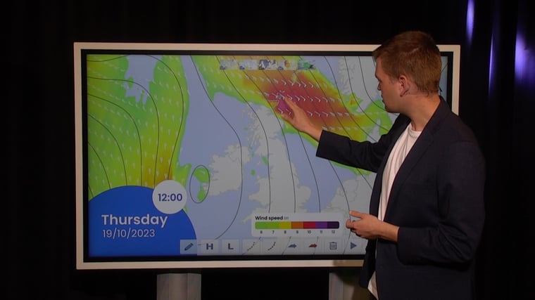
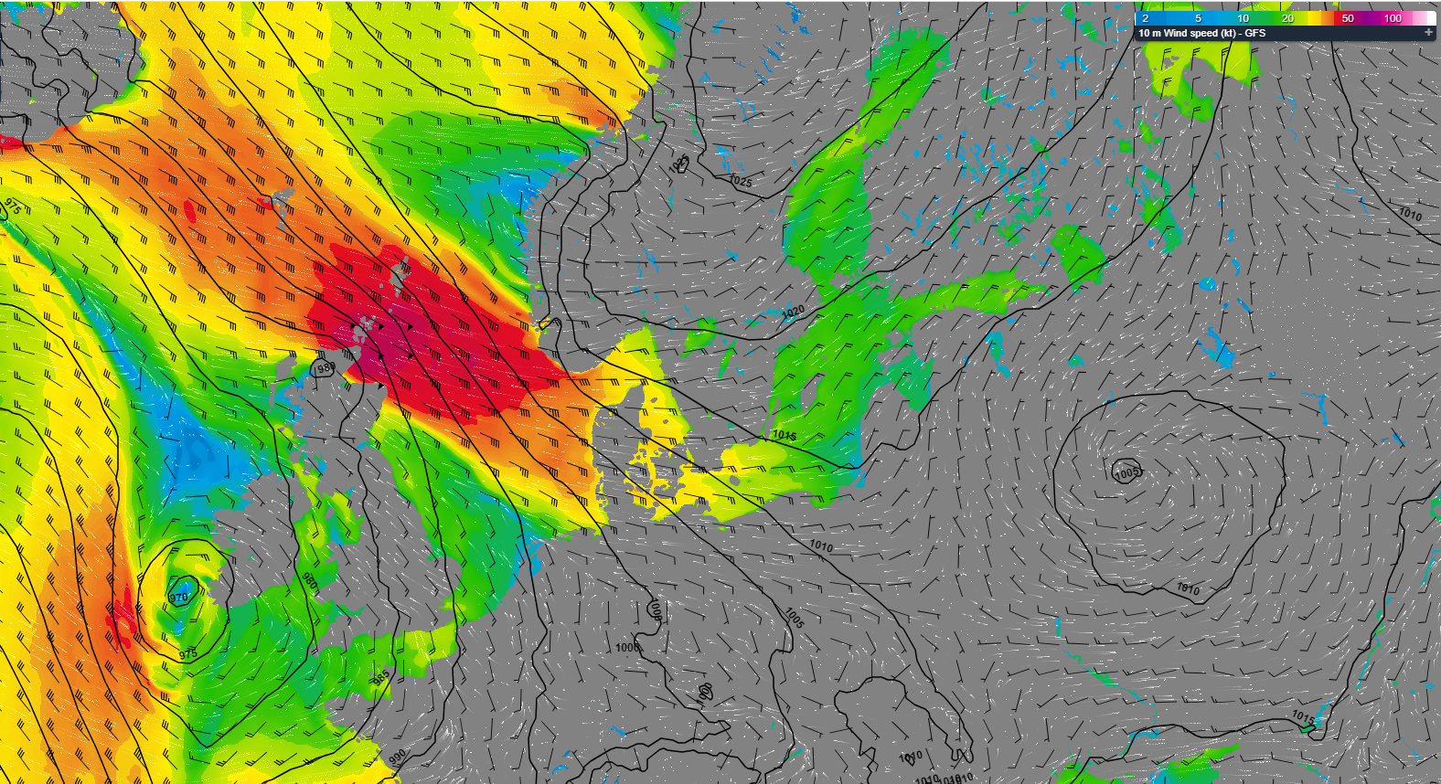 Figure 1: Isobars and wind speed and wind direction on Thursday 19th of October, 12 UTC (GFS).
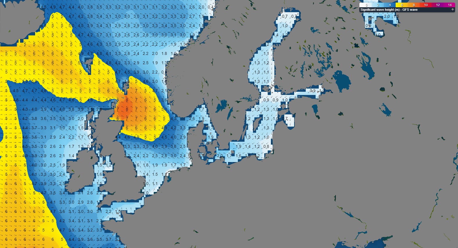 Figure 2: Wave height and direction on Thursday 19th of October, 12 UTC (wave model, based on GFS).
Stormy conditions are expected over the central and northern North Sea on Thursday. ESE’ly winds can pick up to 50 kts, force 10. This results in a significant wave height of 8.0 meters over the northern North Sea. Wave heights decrease towards 5 meters over the central North Sea. A moderate to fresh breeze is expected over the southern North Sea (Humber and Thames areas) and consequently waves will not exceed 3.0 meters and 2.0 meters, respectively, over these areas.
The wind field propagates more towards the south on Friday, with the majority of the North Sea expecting to see (strong) gales, still blowing from the east (35-45 kts). Only the far south of the North Sea (Thames area) sees winds lower than 35 kts. In terms of waves, we expect the highest waves in the northern North Sea, east of Scotland (up to 6-7 meters Hs). Waves in Forties, Dogger and Humber can build up to 5-6 meters. The Fisher, German Bight, Thames and Dover areas experience the sheltering effect, and subsequently waves will be somewhat lower.
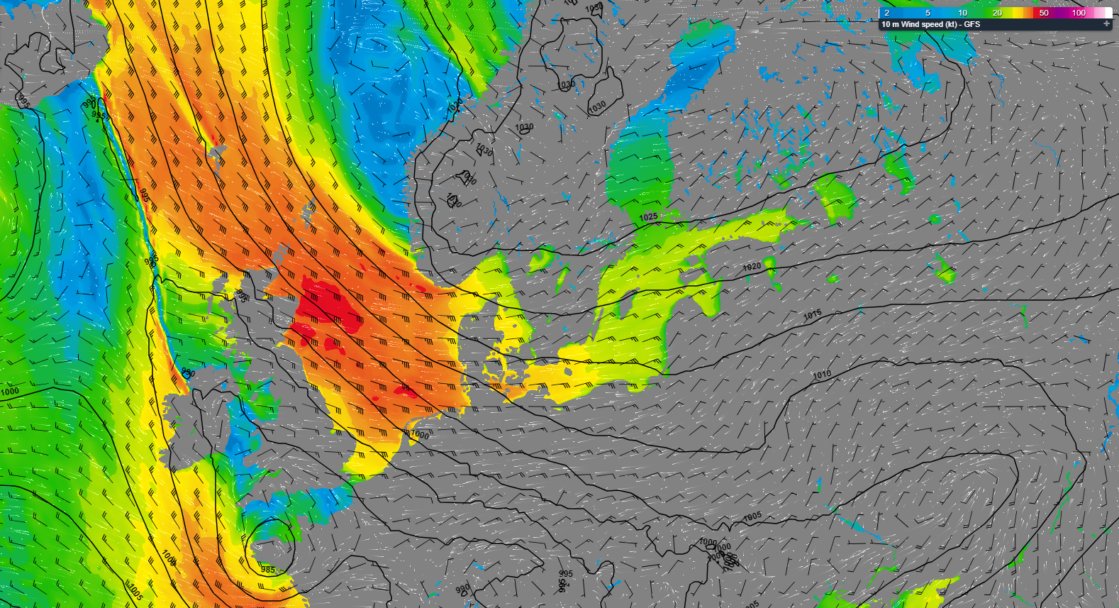 Figure 3: Isobars and wind speed and wind direction on Friday 20th of October, 18 UTC (GFS).
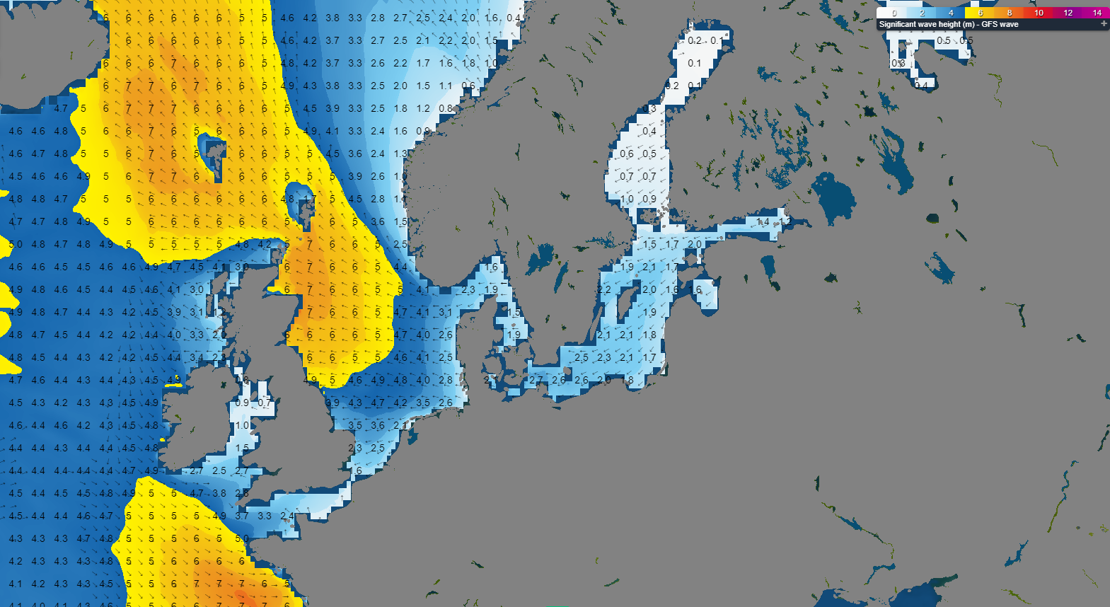 Figure 4: Wave height and direction on Friday 20th of October, 18 UTC (wave model, based on GFS).
The pressure gradient is expected to gradually decrease during the weekend, resulting in a gradual decrease in winds and waves from the south. A strong easterly breeze remains (20-25 kts), with a significant wave height of 2.0 meters in the far south, up to 5.0 meters in the far north of the North Sea.
Conclusion
High-pressure is located over the central North Sea on Tuesday, moving NNE on Tuesday and Wednesday, into the Norwegian Sea and into Scandinavia afterwards. In its wake, low-pressure west of the Bay of Biscay tracks north across the English Channel, expected to reach the UK later on Wednesday. The system affects the North Sea from late Wednesday onward, bringing unsettled and stormy conditions with a lot of wind and high waves. During the weekend, the pressure gradient will decrease, and wind and waves will decrease as a result as well. For now, stay safe and feel free to contact us at any time in case of questions or remarks.
Learn more about the weather
We just launched our new resources page. Here you will find special content like videos, webinars and whitepapers that will guide you to a decision point. Use these expert insights to improve your business or simply to get your knowledge about marine weather up-to-date.