Low pressure areas will linger over the North Sea for a significant portion of the week, while relatively high pressure is located over Scandinavia. The pressure differences are much weaker compared to previous week, resulting in calmer conditions. However, as these low pressure areas over the North Sea fill, unsettled weather conditions are expected for most of the week.
Synoptic overview
Weak high pressure (1020 hPa) is located over Scandinavia and western Russia, while a minor low pressure area is situated just west of the Netherlands (1000 hPa). The low is expected to track slowly to the north on Tuesday while filling. A new secondary low pressure area already formed over the western half of France (995 hPa), tracking northeast towards the Netherlands and western Germany, also filling on Wednesday. The primary low pressure area (970 hPa) remains west of Ireland. An associated frontal trough will reach the far south of the North Sea on Thursday and linger there on Friday. In the meantime, high pressure builds over Greenland. The low west of Ireland starts to fill slowly from Friday onwards. Associated troughs keeps lingering over the southern half of the North Sea during the weekend.
Wind and waves
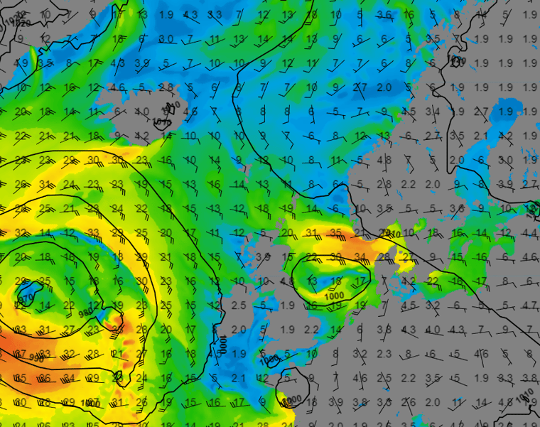
The filling low over the southern half of the North Sea later Tuesday and early on Wednesday will still produce wind gusts up to 35kts on the north side of the filling low (Figure 1). Figure 1: Wind speed and direction according to GFS on Wednesday the 25th of October at 00UTC.
Because of easterly winds on the north side of the low pressure area, there is still a relatively long fetch. Consequently, significant wave height can locally reach 3.5-4m (Figure 2). Further to the north, the wind is calmer, leading to reduced wave heights as well. The same applies for the southern half of the UK and the west and north coastline of the Netherlands. In these regions, significant wave heights are unlikely to exceed 1.5m.
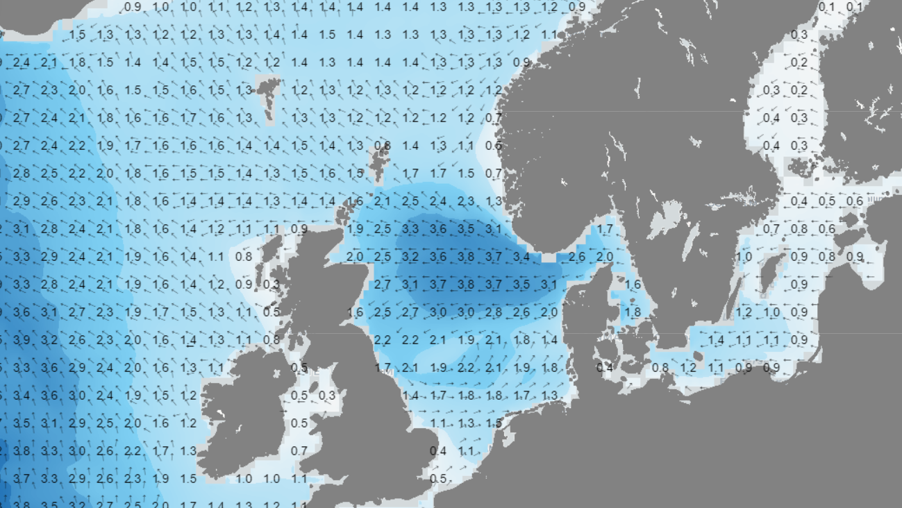 Figure 2: Significant wave height (Hs) and wave direction according to GFS on Wednesday the 25th of October at 00UTC.
The main low pressure area west of Ireland (which is well visible in Figure 1) has progressed to the east as depicted in Figure 3. In this Figure the associated frontal trough lingers over the southern half of the North Sea. This results in an easterly flow over the middle and northern half of the North Sea, due to high pressure over Iceland and the Norwegian Sea. In general, wind gusts will not exceed 20-25 kts at most places. Over the southern half of the North Sea the wind comes from the west, bringing mild and unsettled weather conditions with lots of showers and periods of rain. Although, the unsettled conditions, wind speeds remain relatively calm due to the weak pressure gradient. As a result, the sea will be calm as well with Hs between 0.8-1.4m most of the time. Hs will be varying 2m and at most 3m north of the frontal trough, were moderate easterlies over a longer fetch, will bring somewhat higher waves as well. 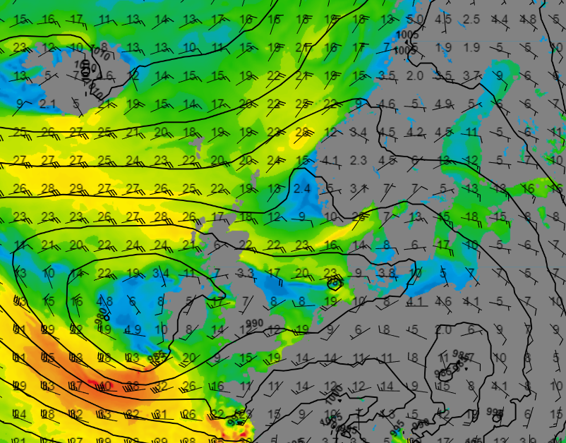 Figure 3: Wind speed and direction according to GFS on the 27th of October at 12UTC.
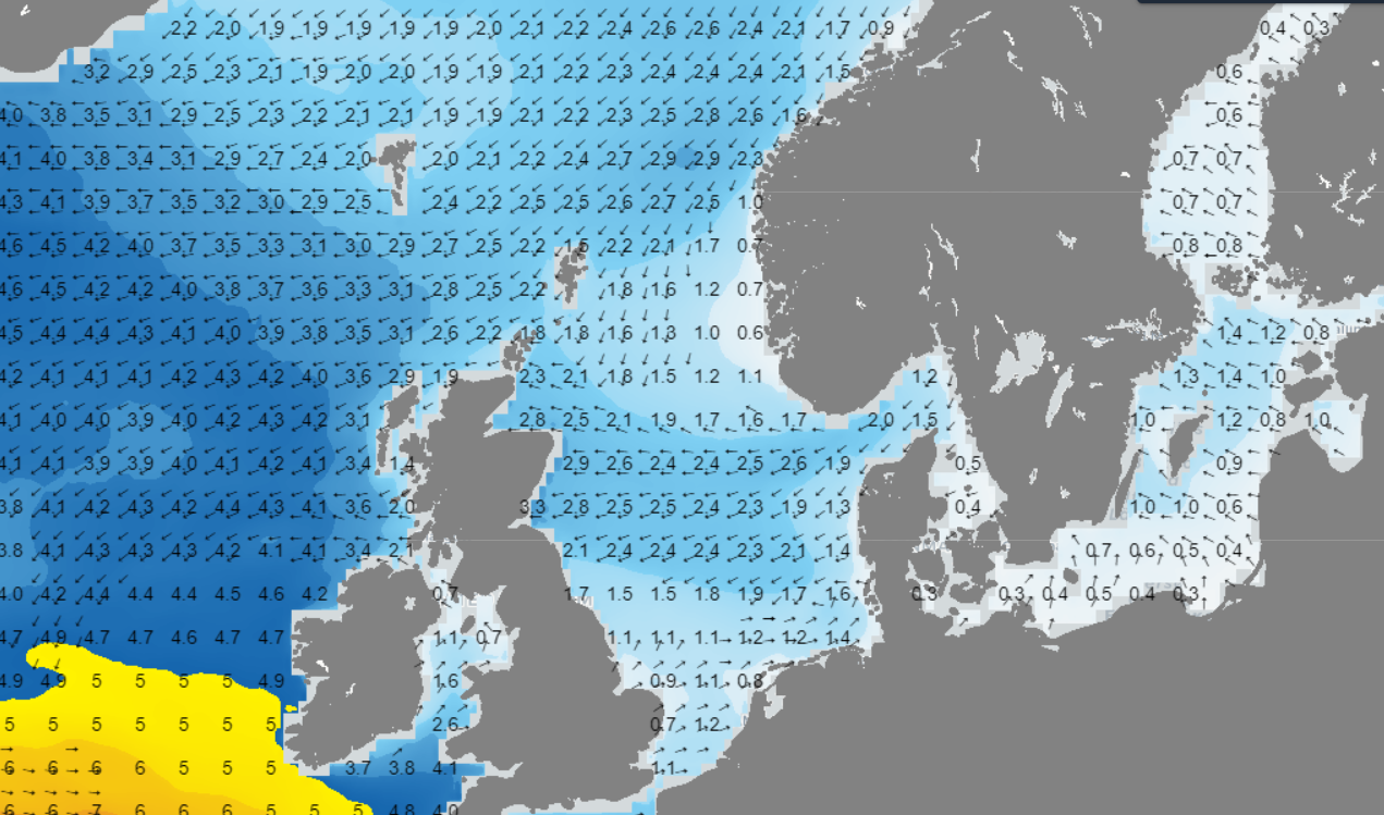 Figure 4: Significant wave height (Hs) and wave direction according to GFS on the 27th of October at 12UTC.
Conclusion
High pressure is located over Scandinavia, western Russia and later during the week over Iceland as well, while a major low lingers west of Ireland. Associated frontal trough and secondary low pressure areas mainly affect the southern half of the North Sea. But due to a relatively weak pressure gradient, wind and waves will stay quite calm most of the time. Just north of the frontal trough, moderate easterlies, in combination with a relatively long fetch, can bring somewhat higher waves over the middle part of the North Sea.Learn more about the weather
If you're looking for more insights, have a look at our resources page. Here you will find special content like videos, webinar and whitepapers that will guide you to a decision point. Use these expert insights to improve your business or simply to get your knowledge about the marine weather up-to-date.