.png?width=760&name=image%20(14).png)
A ridge of high pressure will gradually shift E over the North Sea over the coming days, producing relatively calm weather conditions as a result. Later this week, and over the weekend, Atlantic low pressure activity will regain influence from the W as associated troughs move into the North Sea. Winds and waves will increase, and the chances of workable weather windows are expected to decrease compared to earlier in the week.
Synoptic overview
A strong high-pressure area over Greenland extends a ridge over the UK on Tuesday. The high-pressure and associated ridge slowly shifts eastward across the North Sea during the week. The high is expected to reach Scandinavia over the course of Thursday. By then, an Atlantic low-pressure system extends a frontal trough over the UK, tracking across the North Sea afterwards. During the weekend, high pressure is still present over Scandinavia, while low-pressure lingers just W of the UK. In between, a firm SE’ly wind will persist. In addition, another frontal structure is expected to cross the North Sea.
Wind and waves:
Due to the influence of the ridge, quite calm and workable conditions occur on Tuesday and Wednesday. Moderate to fresh breeze NW’ly winds (15-20 kts) will result in significant waves of 1.5 – 2.0 meters on Tuesday. On Wednesday, winds will veer to a SE’ly direction and decrease to a gentle to moderate breeze (5-15 kts). Due to decreasing winds and a decreasing fetch, significant wave height values will decrease to 1.5 meters.
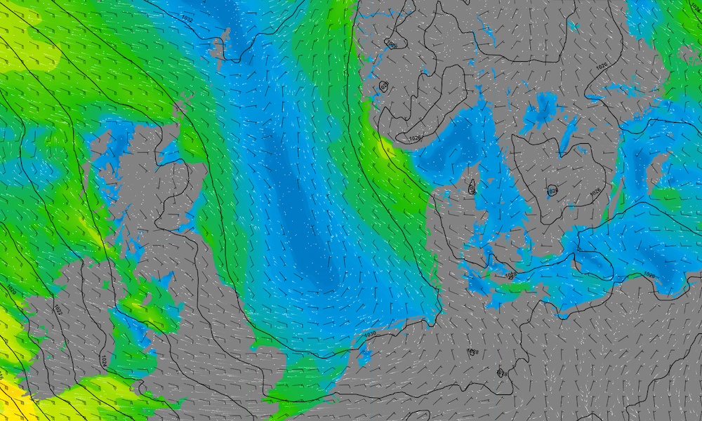 Isobars (black lines 5 hPa) and wind speed/direction (kts) valid Wednesday May 3rd 12 UTC
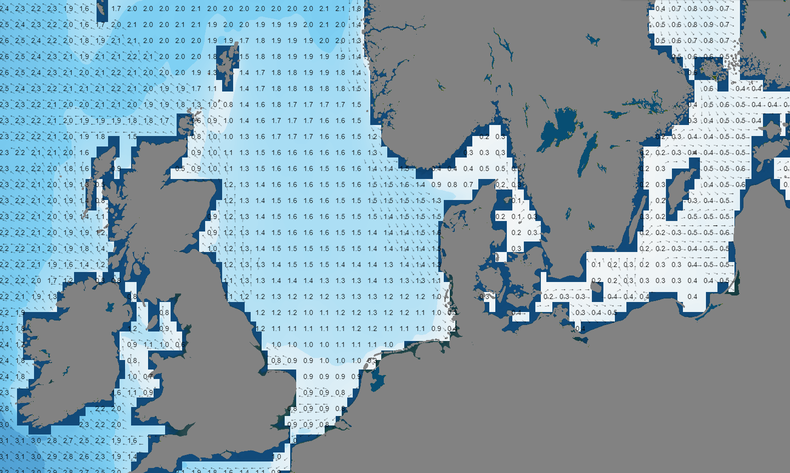 Significant wave height/direction (m) valid Wednesday May 3rd 12 UTC.
From Thursday onwards, weather conditions become more unsettled. Winds increase to 25 kts on Thursday, resulting in waves up to 2.5 meters. On Friday and during the weekend, strong to (near) gale force SE’ly winds occur. Significant wave heights can reach values up to 4.5 – 5.0 meters in the Northern North Sea (longest fetch), 2.0 – 4.0 meters in the Central North Sea and 0.5 – 2.0 meters in the Southern North Sea. The wind field is expected to gradually weaken during the weekend, while the wave field propagates north, resulting in more calm and workable conditions for most of the North Sea area.
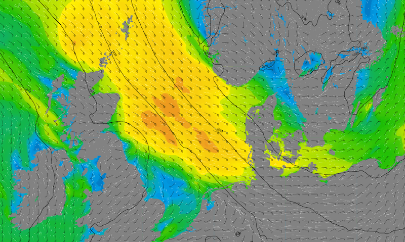 Isobars (black lines 5 hPa) and wind speed/direction (kts) valid Friday May 5th 12 UTC.
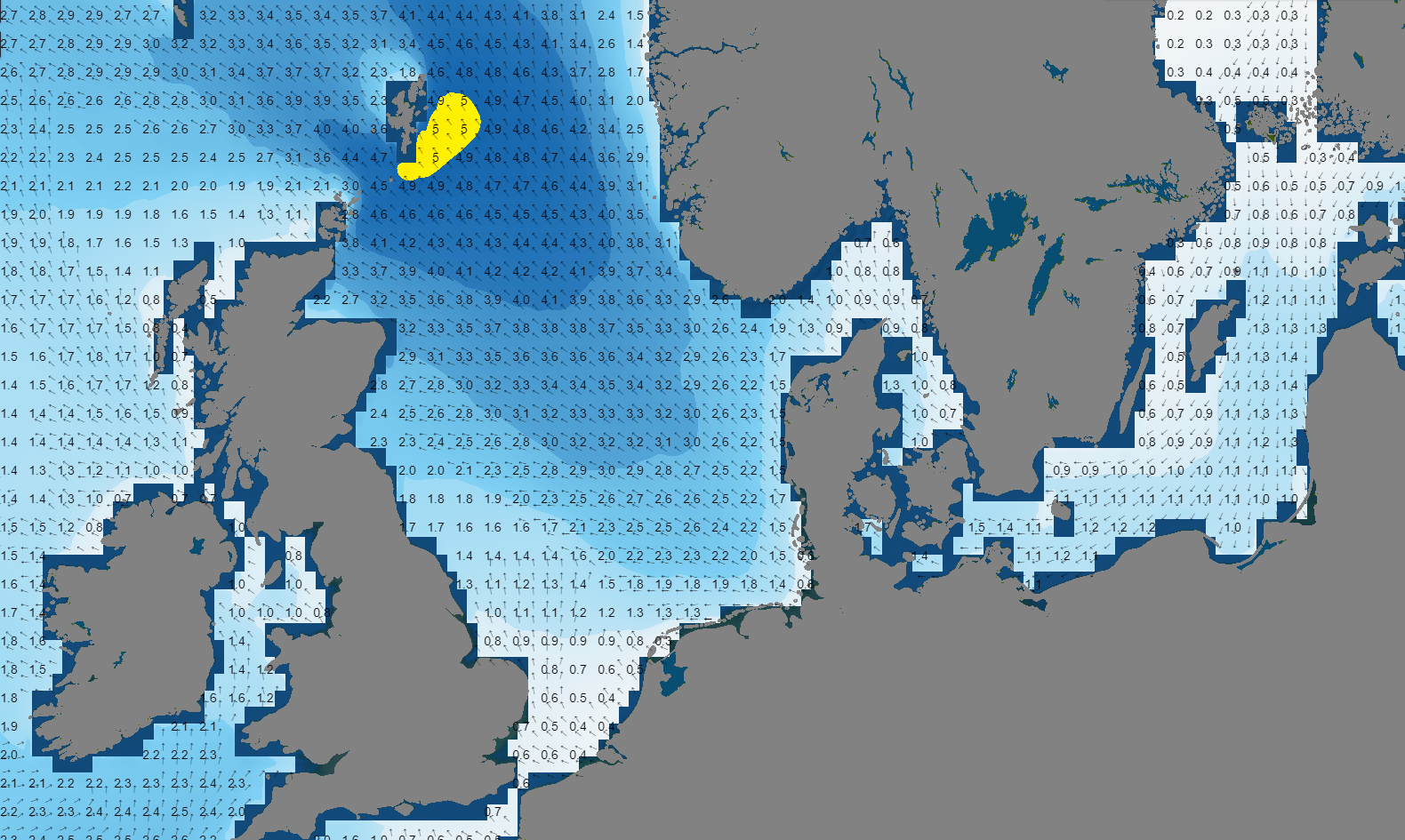 Significant wave height/direction (m) valid Saturday May 6th 06 UTC.
Conclusion
A ridge of high pressure gradually shifts E over the North Sea over the coming days, with relatively calm weather conditions as a result (5-15 kts wind, 1.5-2.0-meters significant wave height). Later this week, and over the weekend Atlantic low pressure activity gains influence from the W as associated troughs move into the North Sea. Winds and waves will increase, and the chances of workable weather windows are expected to decrease with respect to earlier in the week. Risk of fog and/or low clouds increase as well during the weekend.
Weekly weather briefing
Every week we will post an updated weather briefing on the Infoplaza website and the Infoplaza Marine Weather Operations LinkedIn page. We will also share weather related articles and topics on offshore weather on these pages. We hope all our clients stay safe at sea this week. Please feel free to contact us at any time if you have any questions or remarks.