
There are many weather apps in the world to choose from. Mostly, they are focused on the daily use of consumers, and they all look nice. However, for use on sea, these apps most of the times lack a crucial component: a vast amount of grid points.
The more grid points near a location you are measuring, the higher the resolution. This means more accuracy. And that matters in the outcome of a forecast, especially nearshore.
Ultimately, accuracy affects the amount of workable conditions. Here’s why:
Missing sheltering effects
By using free or open-source data services, you’ll often automatically get the forecast of the nearest grid point. So when there’s a low amount of grid points in the area you are operating in, you don’t get the forecast of the actual location you are looking for. In offshore the weather doesn’t differ that much from each grid point, so that isn’t that much of a problem.
Nearshore however, it really can be.
Because of the shape of the coastal line, or the presence of tiny islands, free services are likely to “miss” sheltering effects. This can affect the output of significant wave height (Hs) and wind speed drastically. There can be situations in which an app says there are no workable conditions because it assumes the nearest grid point. To that model, some islands don’t even exist. But in reality, the sheltering effect of a piece of land or an island does cause workable weather windows.
This ultimately equals savings in time and money.
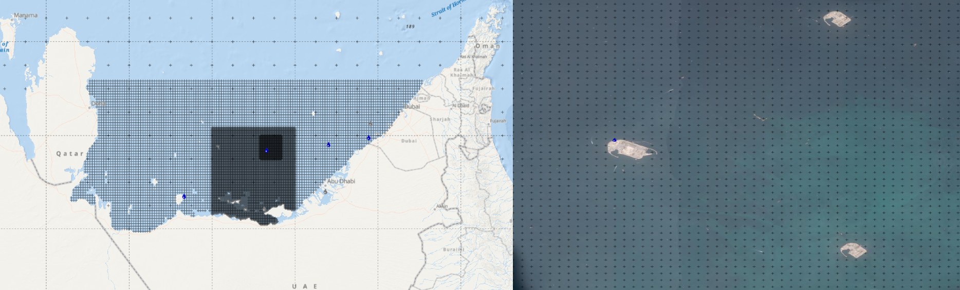 An example in the Persian Gulf. The darker the area, the more 'resolution' the area has. On the right, the nearshore location in the dark square. Free apps might miss these islands completely.
 Lacking bathymetry
Another big difference between open-source services and premium services is bathymetry - or how deep the waters are. Especially nearshore, in relatively shallow waters, this matters a lot. Bathymetry information is not always available in free services.The presence of sand banks and again islands, and wave interaction with the ocean floor is crucial for planning the right vessels for an operation. From the direction of waves, the length of waves and the change in Hs: there can be major discrepancies in the output between free services versus premium ones like Infoplaza.
Also read: How we do wave modeling
No inland locations
What about more inland locations, like harbours or wharfs? Even the most accurate grids made by wave modelers sometimes can’t get a grip on such difficult places.At Infoplaza, we measure weather conditions in these areas with a compass rose. That way, we at least can say something useful about the workable conditions in a harbour or wharf instead of nothing.
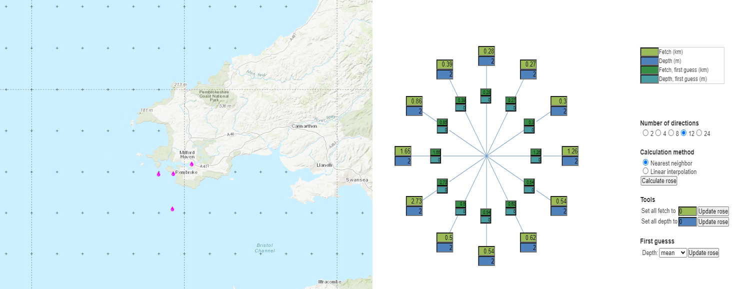 Example: in this area there are 4 nearshore locations. A complaint that we have heard, is that whatever location you click on, the data is the same. This is due to the nearest available grid point not being close at all.
 But the most important difference between free or open-source and premium forecasting services? It’s people.
Absence of humans
At Infoplaza, we embrace technology and we are excited about future developments. However, you can not always rely solely on algorithms. The eyes of experienced meteorologists are simply necessary to interpret the nuances of nearshore operations.For instance: because free or open-source data services don’t use historical data but direct output, there is no database being built to analyse specific locations and local weather conditions. A marine forecaster can see that with a certain wind speed, you can have a wider margin in the forecast.
Next to that, there is simply no possibility to share your own observations with a free weather app. That’s a rather one-sided conversation.
You can see the problem here: while there is direct output, free weather apps don’t offer human interaction. And to us, that defines the strength of a forecasting service.
9 key differences at a glance
| Free forecasting services | Infoplaza forecasting services | |
| Offshore resolution | Sufficient | High |
| Nearshore resolution | Low | High |
| Accuracy on workable conditions | Medium | High |
| Bathymetry info | Not always | Yes |
| Model output | Direct | Direct + Personal |
| Historical data | No | Yes |
| Observations | No | Yes |
| Inland locations | Not possible | Possible |
| Human interaction | No | Yes |
At Infoplaza, a dedicated weather room with experienced marine meteorologists is ready to support your offshore operations, 24/7. Along with our Marine Weather Dashboard, you always have access to the most expert view on weather situations, so you can excel at decision making. 

