Saturday was rather stormy over the north and central part of the North Sea. Storm low Malik passed the south part of Norway causing rough seas and a lot of wind.
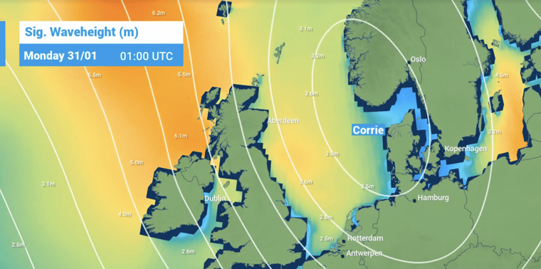
The North Sea area has a short breather on Sunday when a mobile ridge of high pressure is crossing from west to east. At the same time, a new active storm low is developing northwest of Ireland. Sunday evening it will pass Scotland causing rain and snow in the hills and blustery weather. This storm is named Corrie. Corrie will move to the southeast during the night and early Monday morning.
Along the west flank a strong wind field will be present causing gale to severe gale (10 Bft) winds in the districts Cromarty, Forth, Tyne, Forties, Dogger, Humber and Thames. Gusts up to 60-70 kts (110-130 km/hr) are likely especially during heavy showers.
In the eastern districts the wind will be lower. The main wind direction is northwest causing strong building waves during the period. The significant wave height can grow up to 6 or 7 meters. During the peak 7 to 8 meters are possible in Dogger.
In the afternoon the wind will decrease. In the afternoon waves will decrease slowly, first in the northwestern regions. In the evening also in the southern districts.